
The term Claustra Alpium Iuliarum, first mentioned by the Roman historian Ammianus Marcellinus when describing events from the middle of the 4th century,1 implies a defensive-surveillance system whose remains can be found in the area between Rijeka, the city located on the shores of the Northern Adriatic in Croatia, and Baška Grapa in Slovenian Posočje. The system extended across the area that descends from the eastern slopes of the Alps, across the Slovenian Karst, and towards the Kvarner Bay, which the writers of Late Antiquity called Alpes Iuliae. It consisted of defensive walls built in the most strategically vulnerable zones, supplemented with watchtowers and forts to close all of the major crossings through variable topography—valleys, passes, ravines, and creeks—that could be used to penetrate northern Italy from the east. At the same time, they directed and channelled all traffic to the main, controlled roads of Tarsatica (Rijeka)—Tergeste (Trieste)—Aquileia, and Emona (Ljubljana)—Tergeste, and Emona—Aquileia. Precisely along these roads was where the defence system was strongest. Today we are aware of more than 30 km of remains of defensive walls, next to which there are over 100 defensive towers. Remains of the defensive system can be traced in an arc over 130 km long, across the territory of today’s Croatia and Slovenia. It is assumed that at least three major forts (Tarsatica, Ad Pirum, and Castra) located on or near the main defensive lines and four smaller forts (Solin above Kostrena, Gradina near Pasjak) near or on the defensive lines (Brst pri Martinj Hribu and Lanišče) form part of this system (Fig. 1).2
Figure 1: Geographical map with confirmed structures of the Claustra Alpium Iuliarum system.
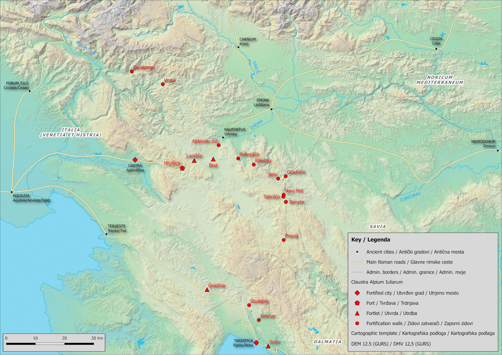
Credits/sources: Kusetič 2019, p. 16-17.
Historical data on the system
Defensive activities in the Julian Alps are not exclusive to the 4th century. Historical sources provide information about the use of Alpine passes with the aim of defending Italy in the period preceding the creation of the Claustra Alpium Iuliarum system. Already in the 1st century, turmoil was instigated in AD 14 by manipuli stationed in Nauportus,3 and praesidiae which were stationed in the “Pannonian Alps” in AD 69 during the conflict between Vespasian and Vitellius.4 Historical data from the second half of the 2nd century mention the incursions of the Marcomanni and Quadi through the Julian Alps, where there was, judging from the cited sources, a level of organised defence.5 Another piece of information leads to the conclusion of the presence of the army in the first half of the 3rd century during the so-called Bellum Aquileiense6 when the existence of certain barriers has already been mentioned here. This information suggests that at least part of the defence structures were already formed then. All this leads to the conclusion of the strategic importance of this area, which was especially emphasised during the war dangers in which Italy itself was threatened.
M. Aurelius Claudius Quintillus, the brother of Emperor Claudius II, administered the eastern Alpine defences in AD 269 and 270.7 This is also the only information from the 3rd century related to the defence of this region. Judging by the archaeological evidence, this may indicate the functioning of an earlier incarnation of the claustra system from the second half of the 3rd century.
During the 4th century, news of the eastern Alpine defensive system becomes increasingly frequent. The sources inform us mainly about conflicts between emperors and usurpers in which the Alpine barriers were used. The conflicts between Magnentius and Constantine II in 3528 and Theodosius and Magnus Maximus in 3889 are notable, but the most frequently mentioned event related to the claustra system is the conflict between Theodosius and Eugenius on the Frigidus River in 394.10 From the words and writings of St Ambrose we learn of the dangers that threatened northern Italy during the incursions of the Sarmatians and Quadi in the second half of the 4th century where he mentions the construction of the Alpine fortifications.11
In the 5th century, Prosper Tiro12 observes that Aetius failed to use the Alpine barrier, at which he could have halted his enemies. As a result, in 452 Attila led the Huns into Italy.
The Notitia dignitatum is the most significant document in which we find data on the Claustra Alpium Iuliarum in the 5th century. In the Notitia we find the area referred to as the Tractus Italiae circa Alpes.13 The Tractus was under the command of the comes rei militaris Italiae, who was subordinate to the highest-ranking general, the magister militum praesentalis. The comes divided the entire Alpine zone, also referred to as the limes, into sectors, including the Julian Alps sector. Active in these zones were the legiones Iuliae Alpinae I, II, III.14 The Notitia dignitatum, however, is a document likely compiled from various manuals created in different periods, such that it does not record actual conditions on the ground in any given period, especially with regard to the western portion of the Empire. The data concerning the Julian Alps probably pertains to the very end of the 4th century.15 With the exception of Prosper Tiro, there are no more mentions of the Claustra Alpium Iuliarum system from the 5th century.
Basic features of the system
The Claustra Alpium Iuliarum saw the construction of structures concentrated on the most important traffic routes to supplement obstacles in the natural topography. The walls of the defence system were not built as a continuous defensive line, but in discrete and separate lengths in locations that offered the most favourable access or penetration from the east, specifically for those coming from the direction of Dalmatia, Pannonia (Savia) and Noricum (Noricum Mediterraneum) towards north-eastern Italy and its most important centre, Aquileia. The Alpine barrier is comprised of a series of defensive linear walls, fortified with towers. At critical and exposed places, the lines were fortified with large passages and gate towers with a fortlet or fort. Documented stretches of the barriers run from several metres to several kilometres. They were built in a manner that leveraged natural obstacles to the greatest possible extent, and closed valleys or ridges along which a Roman road ran.16
The walls of the system were built in three different ways. They were all built from local limestone, and the most common ones were approximately 2 m wide with mortared stone. Mortared walls whose width reached 1 m were the next most frequently found, while the rarest segments are those constructed using a dry stone building technique of 2 m width. At places along the narrow 1-m-wide wall we have documented small buttresses or supports on the defended side of the main barrier wall.17 They are 1 × 1 m structures, placed at various intervals, from 2.1 to 6 m, usually at distances of about 3-4 m. It is held that their primary purpose was not to buttress the wall but rather to support a wooden gallery running along the wall18 along which soldiers could move. Walls with a width of 2 m did not require any such support structures. They were sufficiently broad for soldiers to walk along them and it is held that they possessed a breastwork and that their overall height did not exceed 3 m.19 There is evidence that the walls were plastered.
Towers were generally located where there was a change in the course of the wall, as well as at key vantage points for observation, and to a lesser extent perhaps in positions to support the intervisibility between towers.20 The towers were built for the most part abutting the defended side of the barrier wall, and occasionally projecting equally from both internal and external faces of the wall. Considering the depiction of the defensive walls in the Notitia dignitatum21 it is held that the towers were two-level affairs. The peak of the defensive wall was likely at the level of the first floor of the tower.22 The roof structure was likely made of wood. Like the defensive wall, the towers, too, were rendered with lime plaster.23
At the strategically most important positions, the walls were strengthened with smaller and larger fortifications. Two smaller forts are located directly on the road at Lanišče, near Kalce24 and at Brst at Martinj Hrib near Logatec,25 while the others are located in their vicinity (Solin and Gradina near Pasjak). The largest and strongest fort in the northern part of the system was Ad Pirum, which probably played a key role in this part of the defence.26 In addition to the aforementioned fortifications, the system also included two fortified towns. The first was Tarasatica, which was incorporated in the defensive walls, represented their origin, and was the only sea port of the system and therefore an extremely important element of it. Second was Castra, which was located in the hinterland of the defensive structures.
The north sector of the Claustra Alpium Iuliarum defensive system
The northern part of the system, located on the territory of today’s Slovenia, was concentrated on the communication route between Emona–Tergeste and Emona–Aquileia. In the area north of Snežnik, all possible passages to Italy were closed by defensive walls. We find them near Benete, on Taboršč, on Novi Pot, along Gradiški vrh near Rob, Sela near Rob, on the ridges of Rakitna, along Pokojišče, between Verd near Vrhnika and Marinčev Grič above Strmica.27
Most of the defensive structures were connected to the defence of the road that led through Emona, Nauportus, Ad Pirum and Castra towards Aquileia. In this section, the defensive structures controlled and protected approximately 50 km of road. The first line of defence of this important communication was potentially in Nauportus, today’s Vrhnika. It is located on the edge of the Ljubljansko barje, where the swampy plain of the barje and the karst mountain area meet. From here, roads led to the Sava, the Danube and further east on one side and Italy on the other. In late antiquity, the Nauportus fort was built on the site of an older road station, and next to it, a smaller fort at the location of Turnovšče. In the hinterland of the fort, the so-called Ajdovski wall was built over 8 km long, with as many as 62 towers.28 Given the proximity, we can expect a connection between the fortified Nauportus and the defensive barrier wall, but the nature of this connection is uncertain. In a strictly military sense there is no logic in siting a command post and supply hub in front of a line of defence.29
Between the Ajdovski wall and the next large fort (Ad Pirum), there was another smaller segment of ramparts located beside the last source of water before Hrušica, which can be understood as an attempt to monitor and control access to this water; a fort at Lanišče was placed along the Roman road running from Emona to Aquileia below Kalce near Logatec. A rectangular fortlet with a footprint of about 20 × 20 m stood at Lanišče. Its walls were 1.55 to 1.7 m wide, topped by a crenelated breastwork. The associated defensive wall closed the route of the Roman road that was running approximately 20 m away, where it is likely that a gate tower stood.30
The last line of defence and the main support in the system was located in the area of today’s Hrušica. A fort with a 250 by 75 m footprint sits atop the Hrušica massif, on the route of the Emona to Aquileia Roman public road. It was first the site of the In Alpe Iulia road station that was fortified with strong walls in the second half of the 3rd century. The fort is traversed by a wall at its mid-point that divided it into an upper and lower half. The Roman road ran through the lower section of the fort. The defensive barrier walls stretched to the north and south of the fort, shutting off any circumvention and on both of lengths of wall, gate towers were found.31
Not far from Ad Pirum, a little further south on the road, there was a late antique fort on the site of today’s Ajdovščina, which was also an integral part of the defence system.32 Its proximity to the fort at Ad Pirum, the principal point of the northern part of the defensive system, supports interpretations that it had a command and a supply function.33 The site is also mentioned on the Tabula Peutingeriana and Itinerarium Antonini as Fluvio Frigido, and in the Itinerarium Hierosolymitanum under the toponym Castra, which is connected with the battle at the Frigidus in 394.34
The southern sector of the Claustra Alpium Iuliarum defensive system
The southern sector of the Claustra Alpium Iuliarum system had its base in Roman-period Tarsatica, and stretched along the zone bordered by Kvarner Bay and the steep south-facing slopes of the Gorski Kotar highlands between Kostrena and Grobničko Polje on the one side and Pasjak on the other. And while the hill country here is more rolling than alpine, the karst nature of the terrain and, primarily, the natural barrier formed by the canyon of the Rječina River, provide good defensive characteristics and the ability to monitor the surrounding roads. The designers and builders of the defensive structures in the claustra system used these natural features of the terrain to their maximum advantage creating, in the process, a very complex system that, by leveraging both natural and artificial barriers, effectively blocked all potential major inroads from east to west in this area. The Adriatic Sea on the one side and the very difficult terrain of Gorski Kotar on the other—lacking any meaningful westward routes of communication, which significantly broadened the zone protected by this sector of the defensive system. Thus, the nearest adjacent route of communication defended by structures in the claustra system was more than 20 km away in the Prezid valley.
The southern sector of the defensive system was composed of one large fort that grew out of Tarsatica (a civilian Roman-period settlement that had developed at the estuary of the Rječina River from the 1st century) as it was incorporated into the claustra system, two smaller forts that controlled the main road from Senia to Tergeste before and after Tarsatica, and a series of defensive walls that shut off the routes of communication at the most vulnerable positions. These walls were reinforced by square towers erected on the defended side of the walls at the strategically most favourable positions (Fig. 2).
Figure 2: The claustra system structures in Croatia.
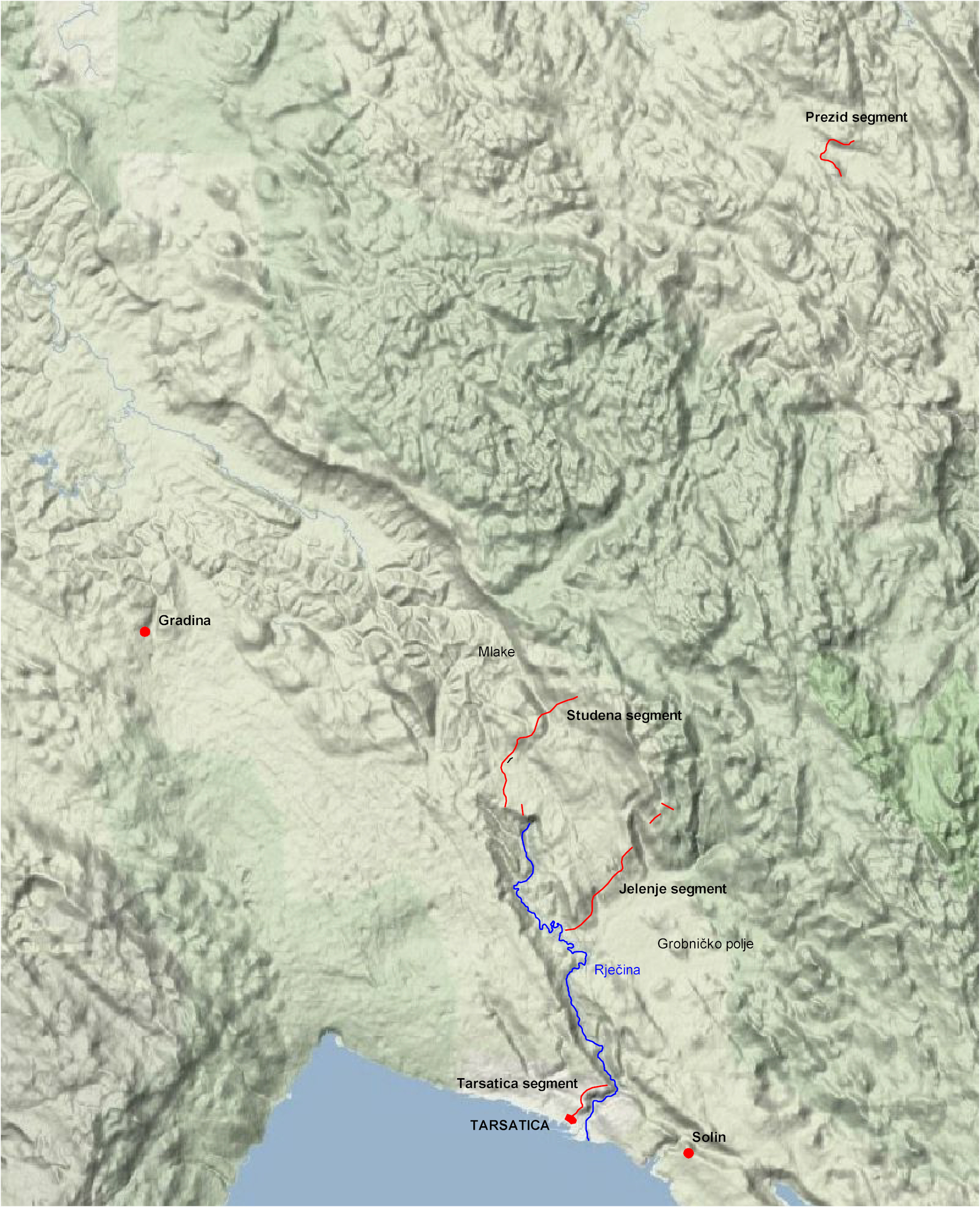
Credits/sources: Josip Višnjić.
Tarsatica
The Roman settlement built at the mouth of the Rječina River emerged in the course of the 1st century, likely during the Flavian period. The archaeologically investigated structures of the first centuries of the settlement’s development broadly follow the shoreline of the time.35 Falling into the same date range is a part of the city’s western necropolis, Andrejščica.36 From the gravestone of G. Notarius Vetidianus Secundus we learn that the city had a municipal council and Augustales in the 2nd century, i.e. that it had the status of a municipium.37
While the second half of the 3rd century is marked by instability in the Empire, Tarsatica’s incorporation into the claustra system marks the dawn of its most prosperous period. This prosperity is explained by the fact that, as the only maritime harbour and as a military command within the claustra system, it became a hub for the absorption and distribution of military units and all of the supplies these units required. Besides the high circulation of military units through the city, it also meant great inflows of agricultural goods, arriving by sea primarily from the North African provinces.38 Besides the agricultural produce, ships also brought in a great quantity of ceramics manufactured in these provinces. All of this is corroborated by the large number of recovered potsherds from this period, which in percentage terms significantly exceed those dated to older or more recent Roman periods (Fig. 3).39
Figure 3: Roman period archaeological structures in the ancient core of Rijeka with indicated zones of excavation conducted by the Croatian Conservation Institute.
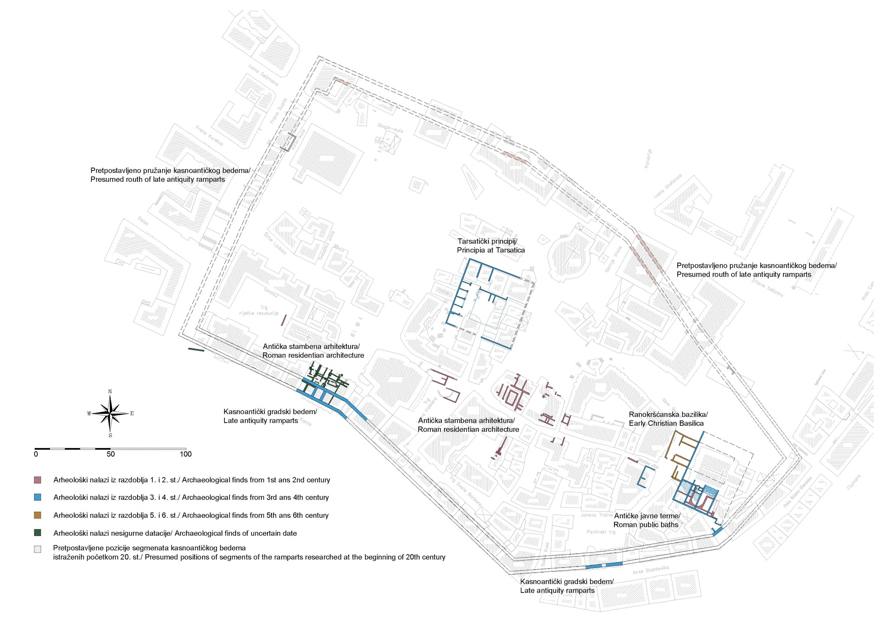
Credits/sources: Josip Višnjić.
This phase of Tarsatica’s history begins with the erection of the principia, a military administrative headquarters in the claustra system.40 This is also the period of the most intensive construction of public buildings in the city, with the construction of imposing new public baths41 and city walls.42
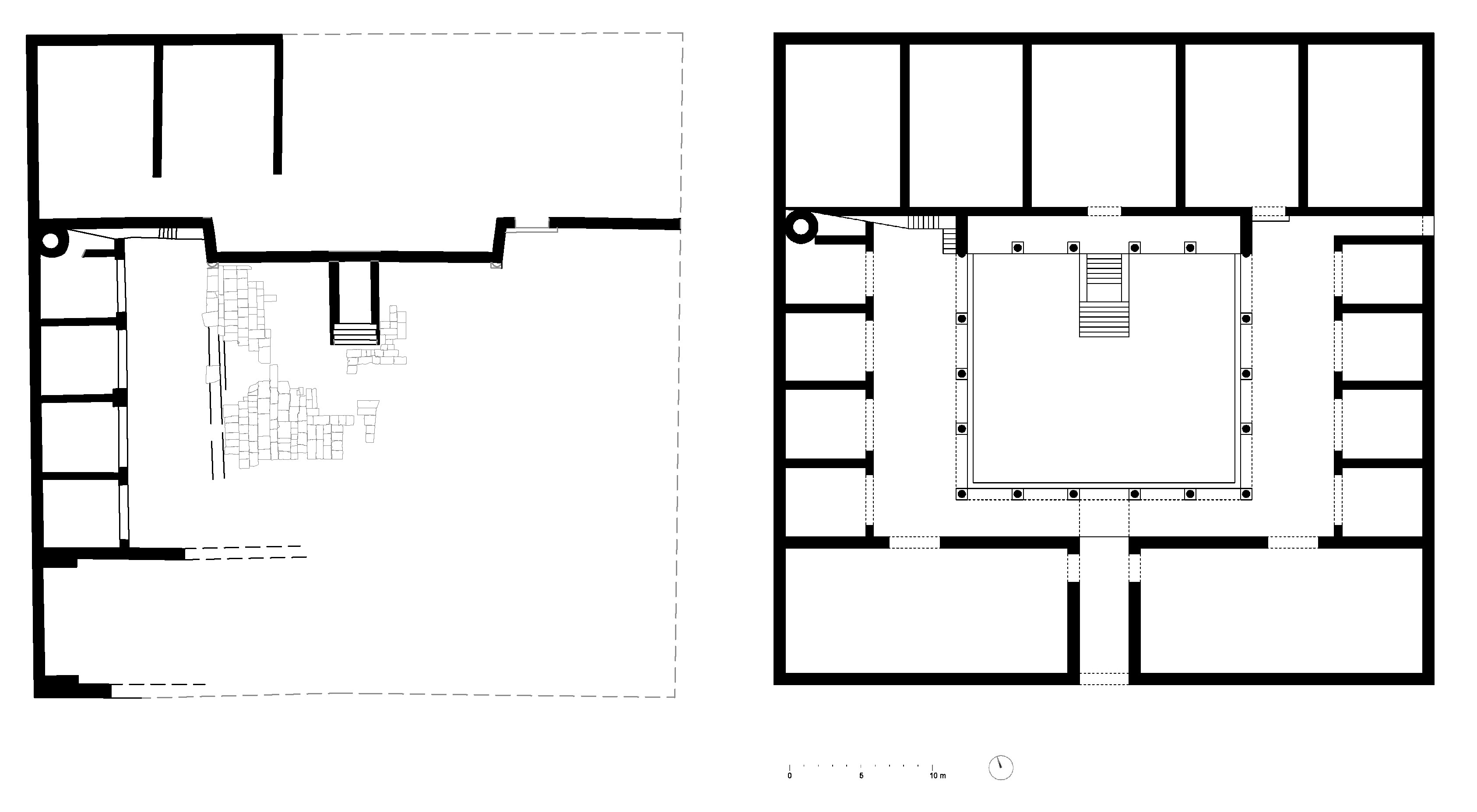
Judging from the finds made during the archaeological excavation in the area of the principia in 2007, its construction can be dated to some point between 260 and 280.43 Thanks to these investigations we have collected a large amount of data that have allowed us to form a picture of what this late Roman complex might have looked like. The principia at Tarsatica is almost entirely consistent with the established typology. The complex was accessed by way of a monumental main gate, preserved to this day at Stara Vrata street (Fig. 4). Set around the central courtyard were administrative and storage buildings that formed a closed area with a square footprint of about 45 × 45 m. Specific to some extent to the principia at Tarsatica is its adaptation to a rocky terrain that slopes down to the south, i.e. to the shoreline, as a result of which the complex was multi-levelled. The area of the courtyard was the lowest part of the principia, the plateaus to the sides were raised from it by about 50 cm, while the highest part was at the north, back end of the complex, raised by about 2.5 m (Fig. 5).
Figure 4: The Roman arch, the former entrance to the principia complex.
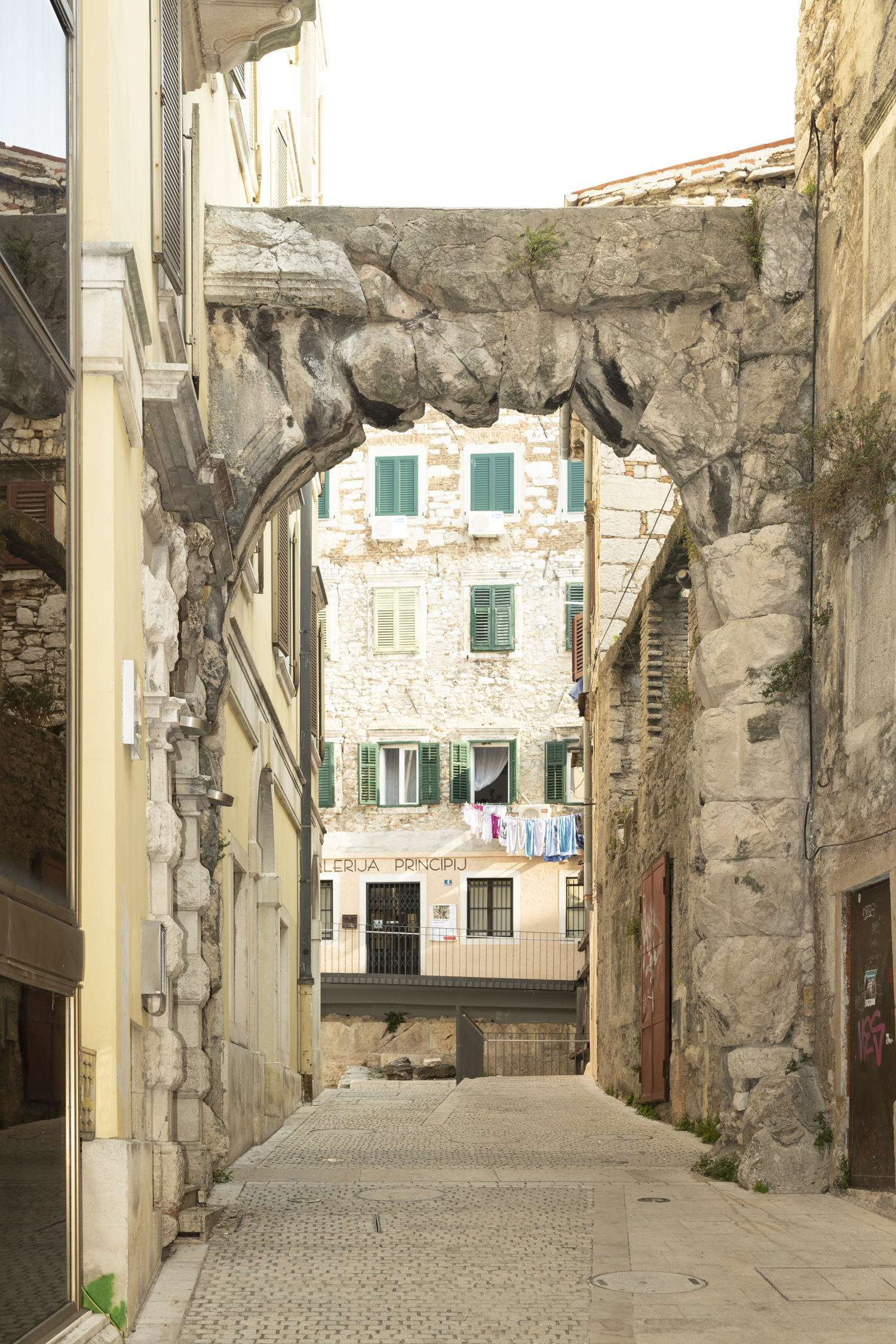
Credits/sources: Natalija Vasić (photo).
Figure 5: The plan view of the excavated parts of the principia at Tarsatica and a conceptual reconstruction of the layout of the complex.
Credits/sources: Josip Višnjić, Vjekoslav Gašparović.
The perimeter and partition walls were built in the opus mixtum technique. The 20.6 × 17.8 m paved courtyard was surrounded on all sides by buildings. On the south side, with the monumental entrance to the principia, the courtyard was closed by a 10.4-m-wide building fronted by a porch. To the sides, on raised plateaus, were buildings divided into four rooms, also fronted by porches. On the north side the courtyard was bordered by a raised porch resting on a wall built of massive stone blocks. The administrative building erected on the north side of the complex dominated the space with its elevated position, defined by the high ground formed of the outcropping bedrock on which it sits. The building occupied the entire breadth of the principia, and the ground floor was likely divided into five rooms. The east wing had its footing at the level of the lateral plateau and thus had one level more than the remainder of the building.44 It is possible that the camp treasury was located here. The space under the central room of the administrative building—likely the shrine of the standards (aedes principiorum), was, namely, often somewhat lower than the surrounding terrain and likely served as the aerarium, the camp treasury. A sunken or semi-basement treasury of this kind came into use at the end of the 1st century.45 In our case here in Rijeka, as has already been noted, the rocky terrain dictated a level of adaptation of the standard architectural form, such that it is not to be ruled out that the camp treasury was placed in a non-standard location. The elevated plateau of the principia was accessed by a stairway on the axis of the main entrance. As smooth dark-red plaster is still preserved on the side walls of the stairway, we can postulate that this part of the complex was also originally covered. In the north-west corner of the complex, where the administrative building abuts the building of the western lateral plateau, is a walled well, which likely originally functioned as part of the principia, also in keeping with customary practice in these types of structures.46
We should note here that Notitia dignitatum mentions that the legiones Iuliae Alpinae I, II, III were active in this zone. The first and third legions were deployed to Italia, while the second was stationed in Illyricum.47 Given the discovered remnants of a military command base and its indisputable importance in the defensive system, we can hypothesise that the 2nd legion was in fact stationed at Tarsatica.48
And while there are no concrete data on the exact time in which the city walls were raised, the fact that the claustra system was created in the second half of the 3rd century, and that the principia was built at Tarsatica around the year 270, leads to a logical hypothesis that Tarsatica must have acquired its walls during this period—besides serving to protect the city, they also took on the function of the starting point of the entire system. The numismatic finds that corroborate a 4th-century date for the raising of the city’s inner defensive walls49 most likely only confirm their reinforcement in the period of the most intensive use of this defensive system.
It appears that the erection of these walls—if we assume the generally accepted premise that the late Roman walls are consistent with the line of their medieval counterparts—expanded the city bounds to the north. In the hitherto undeveloped part of the city now within the urban area encircled by the late Roman defensive walls we see the likely construction of garrison quarters and other facilities to meet the inflow of new military residents. All of the structures dated to this period on the basis of archaeological finds continue to follow the existing orderly planned grid.
Tarsatica was situated directly on the seafront, on the west side of the estuary of the Rječina River, which flowed from the north through a deep canyon to the sea. This natural barrier was utilised to a large extent as a defensive element of the claustra system. The defensive wall ran northward from the city walls. In this section it followed the line of the edge of the canyon, running to the cliffs at its highest point at the Sveta Katarina site.50 Today, unfortunately, the intense urbanisation of the 19th and 20th centuries has seen only small segments of these walls preserved.
The natural barrier formed by the canyon of the Rječina River was used as an integral part of the defensive system for the following 11 km, right up to the source of the river. Given that the canyon reaches depths exceeding 100 m, it is not surprising that there are no artificial barriers in this part of the defensive system.51
The Studena segment
A defensive barrier does appear starting from the cliffs rising above the Zvir spring, running from this position for about 6 km to the north-west, following the configuration of the terrain and adapting to it.52 The barrier runs through the area intersecting all possible routes of penetration towards the Mlaka valley, and terminates at the first steep and high slopes of the mountains that form the head of the largely impenetrable Gorski Kotar highlands. Together with the Tarsatica segment and the Rječina River canyon, the barrier segment at Studena forms an unbroken defensive line of about twenty kilometres.53
A dry-stone wall structure, i.e. a stretch of wall was discovered to the east of the point from which the barrier begins. It is about 600 metres from the core defensive line, runs parallel to it from south to north, and can be followed for a distance of about 200 m. The defenders, very likely in the course of a subsequent construction intervention, thus reinforced the line against any possible penetration and attack at the very head of the defensive wall.
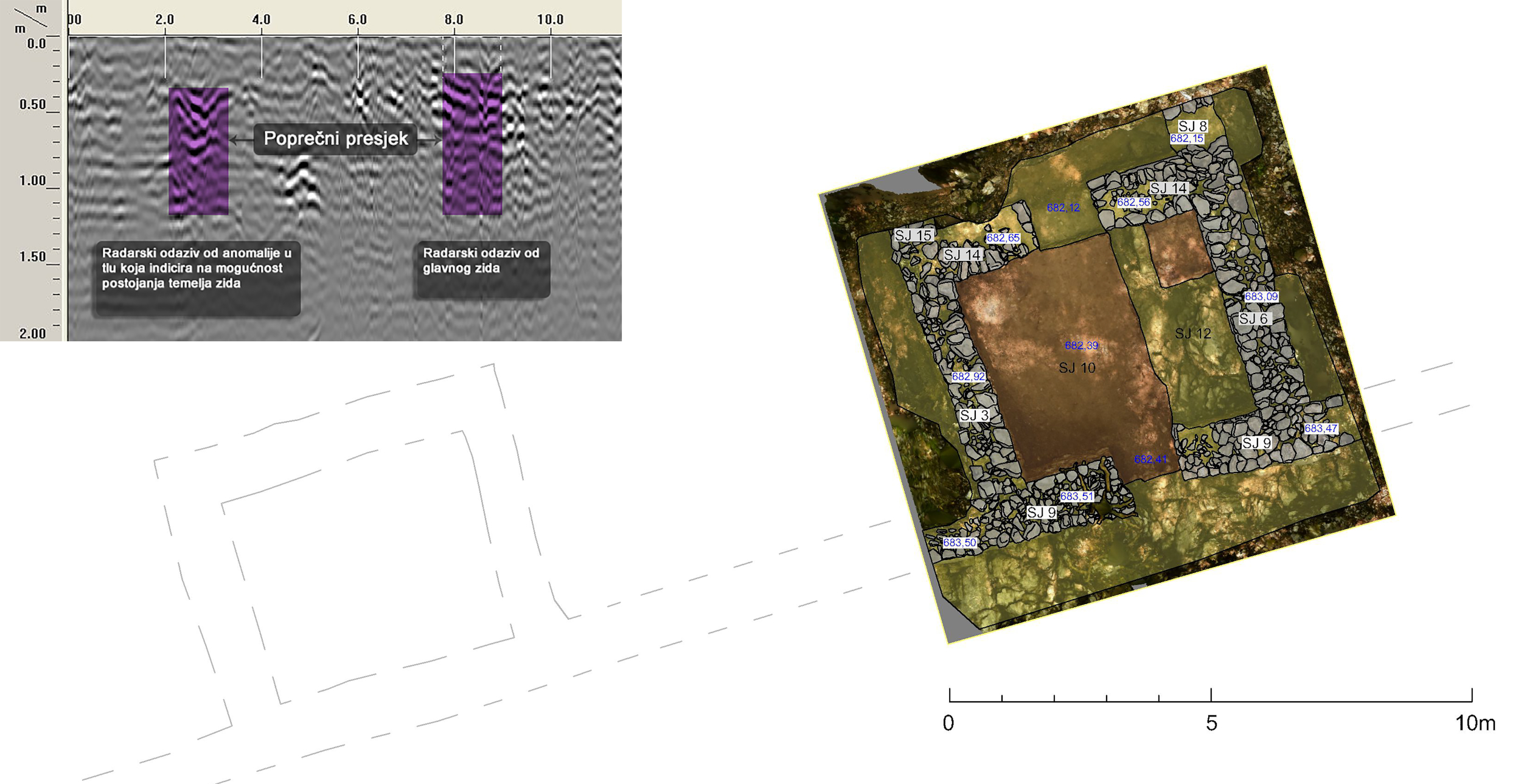
Based on the anomalies observed in the configuration of the terrain from the analysis of the LiDAR imaging and the assessment of the geostrategic significance of the Mlaka valley in the claustra system, a trial archaeological sondage excavation was conducted in 2015. The location was selected based on the hypothesis that one of the Roman-period lines of communication likely passed through this area and on some indicators pointing to the existence of architectural structures created around the configuration of the terrain. Archaeological investigation confirmed the existence of a square tower that, however, entirely departs from the characteristics of the other known such structures along this stretch of the walls. This tower is situated in the valley and is thus not intended for observation of the surrounding area. The entrance and exit portals of this tower reveal a structure meant to control the road, i.e. this is a passage tower. The tower is located on the defended side of the core line of the barrier, its ground plan is 6.6 by 6 m, and its walls are about 1.05 m thick. The maximum width of the entrance portal is 1.35 m and it funnels towards the interior to achieve a minimum width of 1.07 m. The exit portal is 1.2 m wide. Passage towers in the claustra system are currently known at the Hrušica, Lanišće, Novi Pot54 and Solin sites. Two towers were discovered at Hrušica that can be considered passage towers, both with portals for wheeled vehicle traffic with widths of 2.6 and 2.8 m. The eastern tower was 10.7 by 8 m, while the western tower had dimensions much closer to that of our tower of 6.5 by 4.9 m.55 Four square towers were identified at the Solin fort. All four towers have entrance gates at the north, defended side, while the central tower was for passage, i.e. it also has a gate on the outer, eastern wall. The central tower’s outer gate is 0.8 m wide, broadening to the inner gate’s 1.2 m width, such that it is clearly a passage for pedestrian traffic. There is also, however, a 3.1-m-wide carriageway gate between the two western towers with a preserved stone threshold.56
As was the case at some other positions (Benete, the wall between Verda and Strmice, Obrovac-Kalić)57 the investigation of the towers in question also yielded finds that suggest that its interior was plastered. Fragments of roof tiles were not found in the collapse layers, which hints at the possibility that the towers of this part of the claustra system, like those in present-day Slovenia,58 were covered with wooden roofing.
A modest quantity of archaeological finds was collected in the course of excavation, largely associated with the construction phase, such as forged iron spikes. Only a single potsherd was found—the shoulder of a cooking pot decorated with a multiple wavy line motif, decoration associated with the 5th-7th centuries,59 and the recovered potsherd can most likely be associated with activities that took place at this position after the claustra system was abandoned. This hypothesis is supported by the fact that investigation at Hrušica60 and in Tarsatica61 did not yield sherds with these characteristics. The excavation also identified the demolition layer of this structure consisting of collapsed construction material and charcoal, which likely testifies to its violent destruction. A charcoal sample yielded radiocarbon results that suggest use of the location around the mid-4th century.62
The area around the tower was also documented using GPR technology. Considering that only a pedestrian passage was documented in this tower, imaging was conducted of the surrounding area in search of possible carriage tracks. Anomalies in the ground indicate the presence of walls that are perpendicular and parallel to the core defensive wall. Given that the presumed structure has dimensions and a position symmetrical to the excavated tower, and based on analogies with some other sites in the claustra system, the logical inference is that there is another tower to the south of the excavated tower with a similar ground-plan layout.63 This leads us to conclude that two towers once stood at this position, flanking a carriageway passage between them and thus controlling this Roman-period road (Fig. 6). This conclusion is also supported by the example of the Solin fortification noted above.
The investigation indicates that all traffic was likely channelled through a single road, the one running through the Mlaka valley, elucidating the manner in which the control system and passage at this part of the wall were organised.64
Figure 6: A technical drawing of the investigated structures.
Credits/sources: Josip Višnjić.
The Grobničko Polje segment
We also find defensive walls of the claustra on the opposite bank of the Rječina River, in the area above Grobničko Polje. We see remnants of these walls, with small interruptions, running for over 6 km.65 The walls of this part of the claustra shut off routes of communication running north-westwards from Grobničko Polje. On the west side the walls run off from the natural barrier formed by the Rječina River canyon, while on the east side they terminate at the steep and largely impassable slopes of the nearby mountain peaks.66
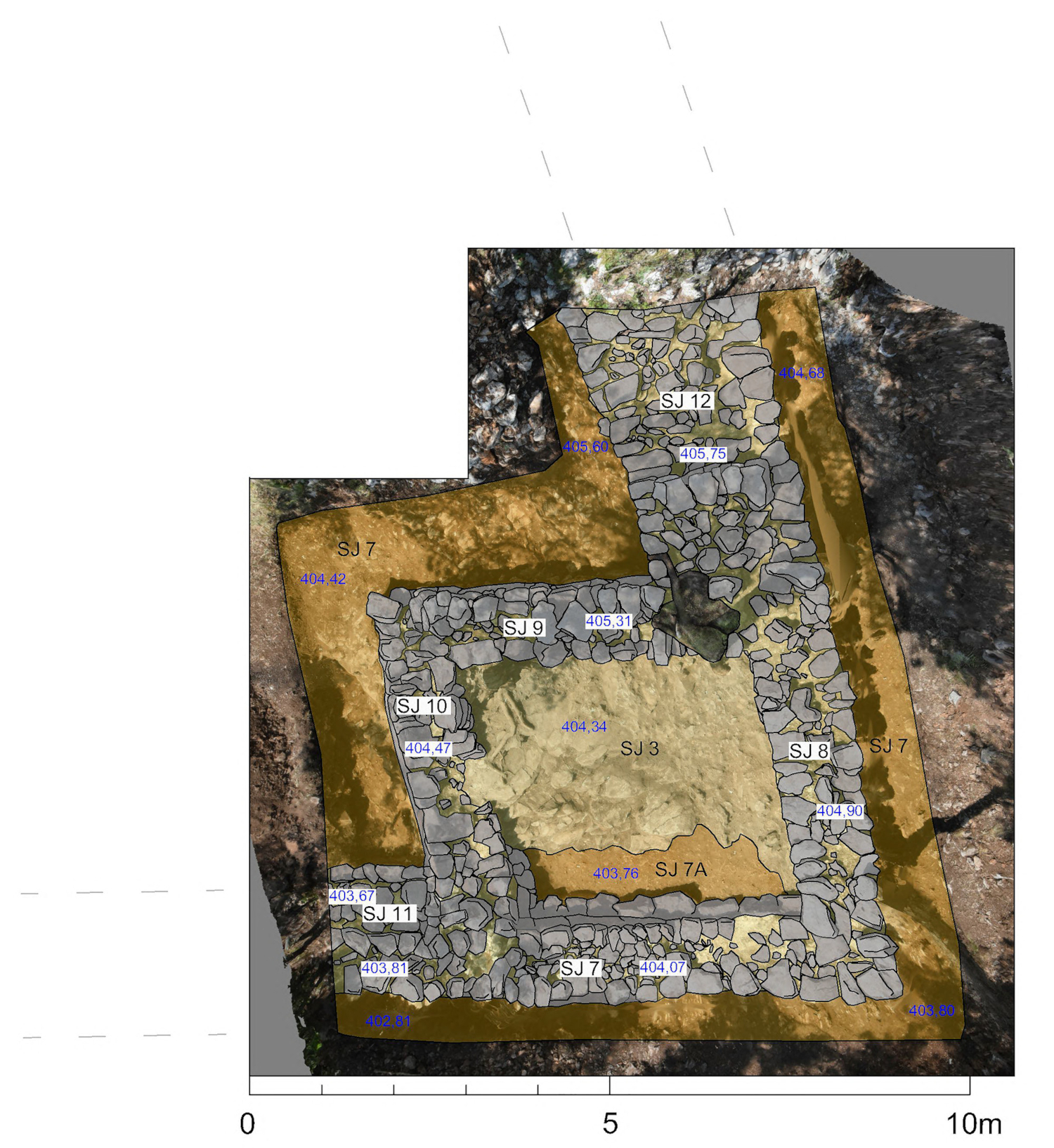
Archaeological sondage excavation was carried out at the Obrovac (Kalić) site, where previous indications had pointed to the likely presence of one of the watchtowers.67 A survey of the terrain and the analysis of the LiDAR data corroborated these indicators and this location was selected for investigation. The excavation confirmed the existence of the tower at the location. This tower stands at an exceptionally good strategic position from which the surrounding area can be controlled. It stands on the defended side of the barrier wall where it turns abruptly to the north after rising out of the valley to follow the ridge of the hill. The tower’s footprint is 5.85 × 5.7 m, and its walls are 1 m thick. The surrounding defensive barrier walls are up to 2 m thick. At the part of the barrier wall that runs directly from the tower towards the south-west, i.e. that descends along the slope towards the valley of the Zala Creek, the wall is built such that a 0.9-m-thick wall leans against a 1.1-m-thick wall (Fig. 7). Given the fact that we see no doorway in the ground level part of the tower, it is most likely that the inner wall was in fact the base of a set of stairs along which one would access a door on the upper storey of the tower. As is the case at some other positions (e.g. Benete, the barrier between Verda and Strmice, Mlake) here too the excavation of the tower revealed finds that suggest that its interior was plastered.68 Fragments of terracotta roof tile were not found here which suggests that the tower had a wooden roof.
Figure 7: A technical drawing of the structures excavated at the Obrovac 1 position.
Credits/sources: Josip Višnjić.
A small number of artefacts were recovered in the course of the investigation that testify to the presence of soldiers at this location, i.e. offer insight into the daily routine here. These are for the most part potsherds and fragments of glass for the storage, preparation and consumption of foodstuffs. Most of the fragments are, unfortunately, very small and offer little by way of grounds for conclusions to be drawn as to their date or provenance. On some of the amphorae sherds we do see a characteristic light slip on the outer face of a red coloured ceramic body, which may be associated with North African manufacture. African amphorae, i.e. African agrarian products, are dominant at Tarsatica in the period during which the claustra system is operational,69 such that the discovery of this ware at a nearby segment of the barrier is, in fact, expected. Sherds from amphorae and pots, glassware and scorched bones show that there was daily activity in and around the towers of soldiers deployed to this part of the system, and we can, therefore, justifiably speculate that the towers also served as temporary lodging for a small garrison.70 Radiocarbon analysis dates activity at this site at the end of the 4th century,71 i.e. in the period of the most intensive use of the defensive system preceding its abandonment.72
Excavations conducted in 2017 further defined the communication routes defended and controlled by the claustra system at the Obrovac 2 site located in the defile below the Obrovac 1 (Obrovac-Kalić) site in the Zala Creek canyon.
The sondage excavation revealed the remnants of the tower with an outer footprint of 7.2 × 7.2 m and 1.5-m-thick walls, preserved only at the footing. The tower straddles the defended side of the 2-m-wide barrier wall that descends from the Obrovac 1 site towards the defile and continues southward. It stands to the east of the present-day route and is approximately consistent in terms of siting and characteristics with the tower excavated at the Mlake-Lipice site. These results led to the conclusion that the route of the Roman vicinal road did in fact run through this location; it is otherwise hard to justify the necessity of erecting a tower in a defile unless it did serve to control a passing road. It still remains an open question whether this was a passage/gate tower for vehicular traffic, as seen at some of the claustra system sites in Slovenia,73 or for pedestrian traffic with an adjacent carriage passage, as we see, for example, at the nearby Mlaka site.74
The Solin Fort
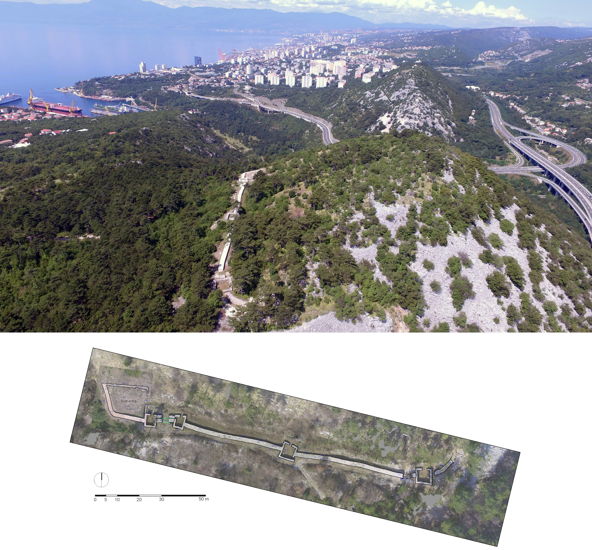
Two late Roman forts situated on the Senia-Tarsatica-Tergeste road, a major transport route, were certainly part of this section of the claustra system. One of these stood in front of the core defensive line, while the other stood to its rear. The fort at the Solin site in the Kostrena municipality is located about 4 km to the east of Tarsatica, at a position that offered good visibility of the approach to Tarsatica from both land and sea.75 It was built directly above the main road and the sea access to Tarsatica, so it could communicate visually with the city itself, as well as with the defensive walls above the Grobnik Field and Studena. Therefore, it had a remarkable strategic role as a kind of outpost and patrol point of the system. It was bordered by steep cliffs on one side, while on the other there was a 2-m-wide rampart with four towers, with pedestrian and carriageway entrances already described. These were towers built along the axis of the barrier wall, i.e. towers that project from both the internal and external faces of the fortification wall. Their sizes vary with the easternmost having dimensions of 7.2 × 7.3 m, the central 7.5 × 7.7 m, and the two western ones 5.3 × 6.7 m, i.e. 6.3 × 5.4 m (Fig. 8).76
Figure 8: Solin with Rijeka (Tarsatica) in the background and geodetic survey of investigated structures at the Solin fortification.
Credits/sources: Josip Višnjić.
The Gradina fort
The other fort was situated at the Gradina site near Pasjak, about 23 km to the north-west of Tarsatica, immediately adjacent to the Tarsatica-Tergeste road.77 Gradina Pasjak has a trapezoidal ground plan, running with a perimeter of about 400 m. At the centre of the site is a round karst sinkhole. There are no visible traces of structures on the ground surface between the sinkhole and the perimeter barrier girdle. There is a 3-m-wide carriageway entrance on the south side of the hillfort, defended by two 3 × 4 m rectangular towers, built abutting the outer face of the barrier wall. On the west side of the hillfort is another carriageway entrance, with a preserved original threshold with traces of the groove in which the wing of a wooden door would have been fixed. This western entrance into the hillfort was also bounded by two rectangular towers, abutting the outer edge of the barrier.78
The Prezid segment
We see no natural westward routes of communication in the uninhabited highland areas of Gorski Kotar stretching some 20 or so km to the north of the Studena segment. There was thus no strategic imperative for the construction of defensive structures of the claustra system in this area. Hypotheses have, admittedly, appeared in the specialist literature since the beginning of the 20th century postulating their existence,79 but surveys of the terrain in the course of 2011 and 2012 did not lead to the discovery of any actual remnants.80
The final segment of the barrier in present-day Croatia is situated at the only natural point of communication that provides unimpeded westward passage from the Gorski Kotar area. This segment of the barrier is located near the settlement of Prezid. The barrier wall cuts across the valley following the current state border, with two arms stretching to the east along the sides of the valley, creating a horseshoe formation. The total length of this segment of the barrier is about 2.8 km, with the length of the section cutting across the valley a little over 900 m.81
It appears that different construction techniques were used in the raising of the crosswise part and the side arms of this segment of the walls. The crosswise section is built using the standard technique, using very roughly dressed stone and abundant lime mortar, while the side arms are built in the dry-stone wall technique.82 There is as yet no clear evidence of a tower at this part of the defensive system.
Interpretation of the southern sector barriers
To understand the logic of how this defensive system was put together we must briefly touch upon the roads that it was created to control and monitor. Tarsatica itself lay on the route of the trunk road that ran from the Dalmatian province, i.e. from the direction of Senj (Senia), to Trieste (Tergeste). This road most likely climbed from the direction of Bakar, via Sveti Kuzam, towards Draga, where it passed below the fort at Solin and the Sveti Križ site, then by way of Gornja Vežica, Krimeja and Sušak83 before descending towards the Rječina River and Tarsatica itself.84
The route the road followed through the city has most probably run through its decumanus north of the baths and in front of the entrance to the principia. Further to the west the road most likely initially follows the coastline and ran through the area where the traces of the western town necropolis were found.85
We can only speculate as to the direction this route followed beyond this point, but it is quite likely that a road drawn in the earliest military maps of the second half of the 18th century may have followed the line of the Roman period road (Fig. 9). We can surmise that in the 18th and early 19th centuries the traditional, historical routes of communication, which had been in use for many centuries, were still in use. The road of the time climbed north-westwards, where it passed under the Gradina hillfort site at Pasjak, which is indicated on the cited maps. The road continued on towards Trieste.86
Figure 9: The structures of the southern sector of the claustra system overlaid on a late eighteenth century military map.
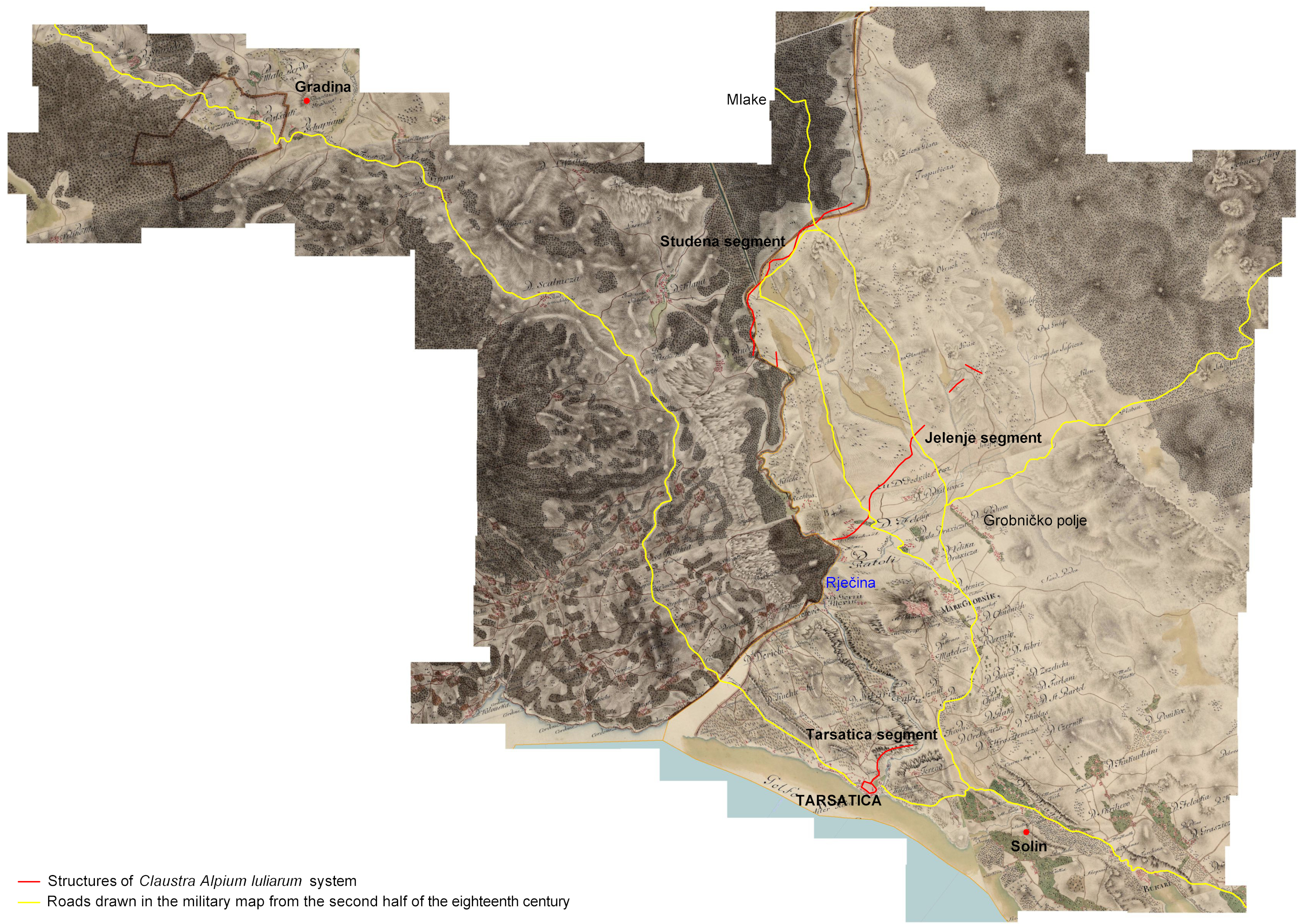
Credits/sources: base map: http://mapire.eu/en/map/firstsurvey; by: Josip Višnjić.
The other two lines of the barrier, the one above Grobničko Polje and the one stretching from the source of the Rječina River towards Vojak, controlled smaller vicinal roads that led from Grobničko Polje towards the Mlaka valley. Judging by the configuration of the terrain, which offers limited transition options, especially in the immediate hinterland of Grobničko Polje, and based on the already mentioned data from the military maps from the late 18th and 19th century, we can speculate as to the two most likely routes. The first of these leads over Podkilavac, following the course of the Zala Creek, where the investigation carried out in 2017 confirmed the existence of a control tower, and then by way of Šijevica and Podvršine arrives at Proslop and the defensive wall. The other line runs from the direction of Donje Jelenje, by way of Kaštelin and Brgudac, to the Ravno site, also at the wall itself. It does appear that all roads were then channelled towards the Mlaka valley where archaeological investigation conducted in 2015 confirmed the existence of two towers that controlled the road.87 This point was also probably the only passage through this segment of the defensive walls, which significantly increased the ability to control and monitor movement.88
It is evident from the above discussion that the defensive structures of the southern sector of the claustra system defended all routes of penetration from east to west. The principal, trunk road was defended by three forts and the Rijeka portion of the defensive walls. The local, vicinal roads were defended by the defensive walls above Grobničko Polje and the source of the Rječina River. Any attempt to avoid the artificial barriers would lead enemy units to the impassable natural barriers of the Rječina River canyon or steep mountain slopes where they could be neutralised with relative ease (Fig. 10).
Figure 10: Parts of the south sector of the Claustra Alpium Iuliarum system on a DEM hypsometric b/w tint scale.
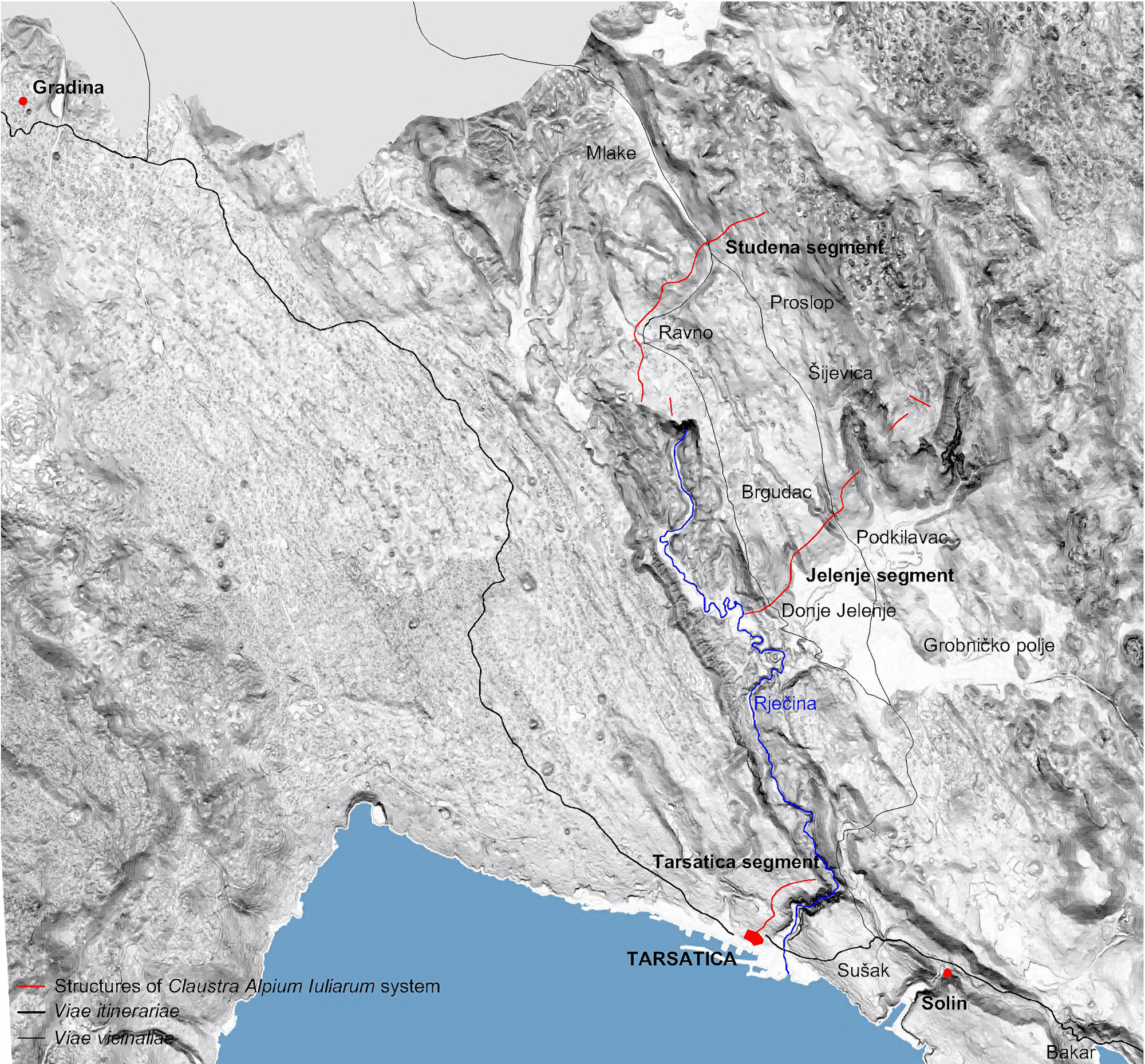
Credits/sources: base map: https://geoportal.dgu.hr/; by: Josip Višnjić.
The earliest finds associated with the structures of the southern section of the claustra system originate from the principia at Tarsatica, the foundation of which has been dated on the basis of numismatic finds to between 260 and 280.89 An entirely logical hypothesis would see the city itself acquiring defensive walls in the course of the construction of the principia or not long thereafter.90 Numismatic finds discovered in the mortar of the southern arm of the city walls, however, confirm that there was some construction activity associated with the walls in the course of the 4th century.91 Given, however, that we see the most significant activity in the overall claustra area92 and at Tarsatica93 during the second half of the 4th century, we can surmise that the mentioned numismatic finds establish that near the end of this century, at a time when the system saw intense use in the face of the latent danger of conflict, the walls of Tarsatica were repaired and are possibly also further reinforced. It cannot be ruled out that the construction of a parallel barrier identified at the southern arm of the city walls did in fact emerge precisely as a consequence of this episode of construction.
The only reliable dating indicators from the defensive walls of the southern segment of the claustra system are drawn from the radiocarbon analyses performed on charcoal samples taken from the Obrovac-Kalić site at the Jelenje segment of the walls and from the Mlake-Lipice site at the Studena segment. The sample taken from the Mlake-Lipice site provided results that suggest the use of the area around the mid-4th century,94 while the sample from the other site provided a somewhat later date.95 What we have here, of course, are just two samples from what is a sprawling and complex defensive system that, consequently, can hardly serve as grounds upon which to base any definitive conclusions, but that certainly may serve as guidelines to further consideration. They suggest that the defensive structures saw intensive use in the second half of the 4th century, and possibly somewhat earlier, but do not reveal the period in which they were erected.
The archaeological finds recovered from the forts/fortlets from the period of the system’s active use are few in number. From the Gradina hillfort site at Pasjak, however, we have a group of twelve numismatic finds recovered “along the foundations of one of the towers”, the most recent of which was struck in 270. Given the discovered burnt layer, the field director of the investigation concluded that the fort was destroyed sometime around the year 270.96 Mindful, however, of the uncertain context of the finds and the dates within which other sections of the system were in operation, the more realistic supposition would be that these finds are from the period of the erection of the fort.97
The final chapter in the utilisation of this part of the system corresponds nicely with the dates that frame the whole of the defensive zone and is written sometime around the year 400. These indicators are very much expressed at the principia at Tarsatica98 and similar corroboration comes from the above-mentioned analysed charcoal samples. This is the same situation as that we see at other sites located in present-day Slovenia, including Hrušica, Martinj Hrib and Lanišće.99
Whether or not some other sites were incorporated into the claustra defensive system remains an open question. No remnants have yet been discovered of forts that would have been integral components of the defensive sector above Grobničko Polje and at Studena, and the logical question that arises concerns the lodging of military units while deployed to the defensive walls. Recent finds from the Obrovac-Kalić site suggest that soldiers stationed in this part of the system100 went about their everyday activities in the immediate vicinity of the tower, such that we can speculate that the towers were also used for the temporary lodging of units.101 This leaves open the possibility that the bulk of the army was stationed at Tarsatica, with the towers used for lodging during periodic deployments to the defensive walls, located relatively close to the city. In the case of the Prezid section of defensive walls, which are quite distant from major urban centres or the base of the military administration of the claustra system, the situation was, probably, somewhat different.
Conclusion
Despite the evident complexity of the system that suggests that it is a well-designed project accomplished with significant investments, the exact reason and incentive for constructing the system is not known. Control and defence evidently had to move deep into the interior of the Empire already during the 3rd century, due to increasingly frequent barbarian incursions. They were organised far from the limes creating new surveillance and defence zones intended to protect much smaller territorial entities. The barbarian incursions were probably therefore the impetus for the construction of the system, while the written sources most often mention its use in the context of the civil wars of the 4th century. The most numerous archaeological findings throughout the system are precisely from the 4th century, so it can be concluded that this was the time of its most intensive use. The system probably had both a defensive and a surveillance function with the aim of directing the traffic of people and goods towards controlled leading to north-eastern Italy. The army probably stayed in the associated fortifications in greater numbers and for a longer period of time, while the use of the defensive walls and associated towers, at least as far as can be concluded from the amount of small archaeological finds collected during the research carried out in these segments, was occasional and short-lived. In addition to the defensive function, Tarsatica evidently also served as a very important centre for the supply of the army, but it was primarily the southern segment of the system that could be supplied from it. How the supply of other parts of the system was organised remains uncertain for now. This, as well as numerous other questions, remain open for the time being, but the information that has been gradually collected over the past hundred years has made it possible to place the Claustra Alpium Iuliarum system in the context of the late antique period, whose unstable and, for the Roman Empire, devastating consequences, it depicts almost perfectly.
The abandonment of the system happened in the first decades of the 5th century, judging by the artefacts and results collected throughout the system. The system was no longer used after that, as evidenced by historical and archaeological sources. Here, too, the question of why it was abandoned remains open. Whether it was the mere inability of the then Western Roman Empire to organize the functioning of such a complex system or whether it was the result of a series of violent events that could have had a decisive influence on its abandonment remains an open question. Traces of a fire that occurred during the reign of Theodosius or Arcadius and Honorius102 were recorded on the Tarsatica principia, after which it was no longer used. The city still continued to function, but with significantly less activity. The Ad Pirum fortress was abandoned later in the second decade of the 5th century,103 while the activities in Castra can be traced back to the third decade of the 5th century.104 It was a time of very dynamic events in the area of Pannonia, Noricum and northern Italy, but the sources do not mention specific data about the use of defensive structures in the conflicts of that time. The system therefore, at the time when it was most needed, was no longer in operation and could not perform its primary task: traffic control and protection of Italy. It was just one in a series of indicators of the weakening of the western half of the Empire, which gradually extinguished and disappeared in the whirlwind of historical events shortly thereafter.