
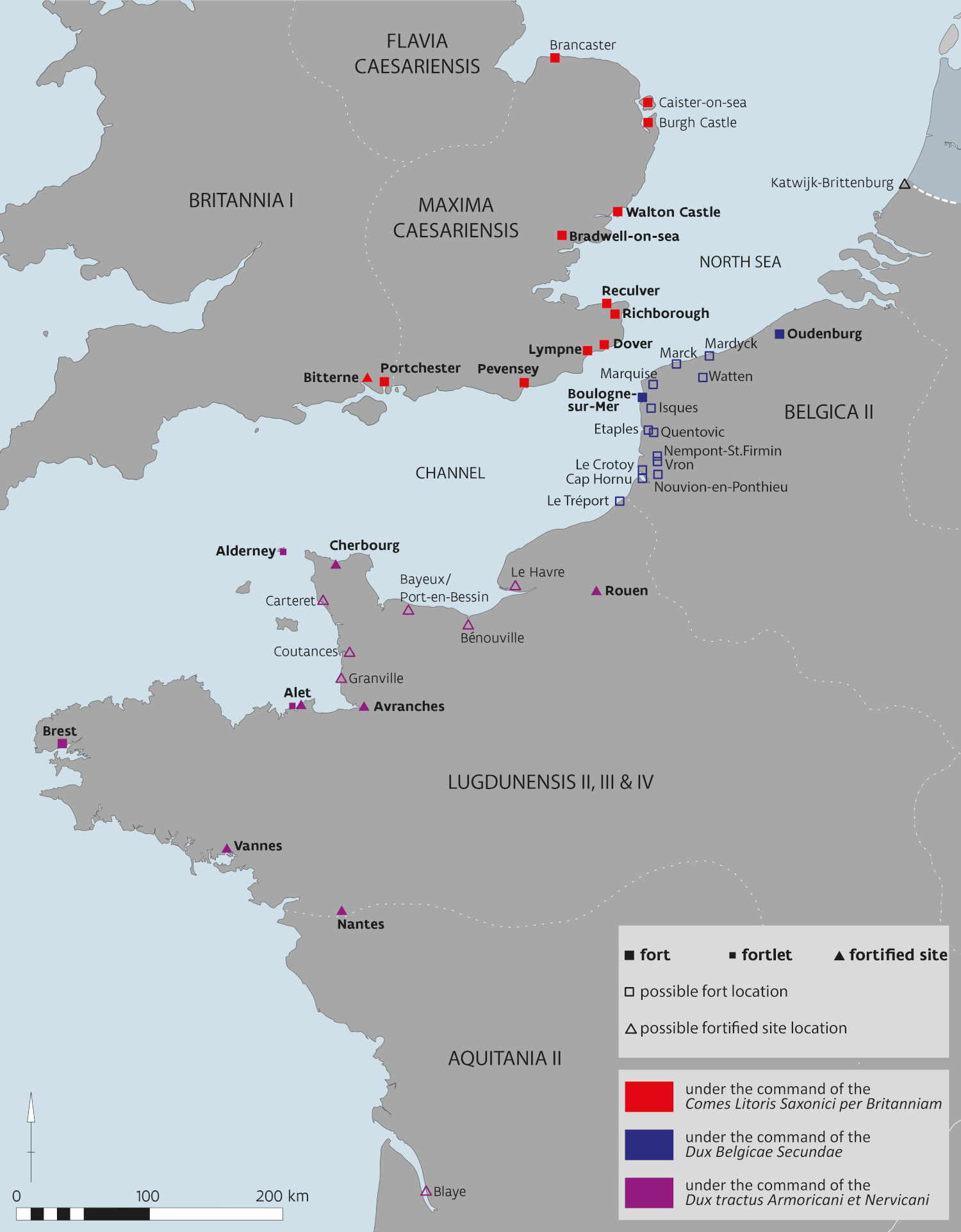
The Litus Saxonicum or Saxon Shore1, the late Roman large-scale defensive system along the North Sea and Channel coasts, has traditionally not been perceived as part of the limes, the established border of the Roman Empire. However, it does form the north-western geographical frontier of the late Roman Empire with the sea, the edge of the then known world. Britain was unique in being accessible only by sea. The British and Gaulish coasts became progressively more militarized from the late 2nd century onwards as a result of increasing seaborne pressure by Germanic tribes coming from the north. The defence of these coastlines mainly comprised a series of castella and fleet bases, implanted at river mouths and on important crossings of waterways and roads. During the 3rd century, several new forts were built along the coast of South-East Britain and along the Gaulish coast, and by the 4th century many of these were united into the Litus Saxonicum (Fig. 1). In Britannia their associated units were grouped under the command of a senior military official, the Count of the Saxon Shore (Comes Litoris Saxonici per Britanniam). The only source for this title is the Notitia dignitatum, a list of officials, civil and military, throughout the Roman Empire, compiled during the late 4th-early 5th centuries.2 The designation Litus Saxonicum is also noted under two continental coastal commands, those of the Dux Belgicae Secundae and the Dux tractus Armoricani et Nervicani in charge of the shores of Normandy and Brittany.3
Although the archaeological record has its limitations and several questions remain open, the general development of the Saxon Shore and its evolution is provided here. As such, the interpretation takes account of the latest archaeological evidence, but does not provide a thorough re-evaluation of earlier hypotheses based on historical, linguistic, or iconographic analyses of the Notitia and other literary sources.
On both the British and Gaulish side, sea level change, erosion, sedimentation and human intervention have altered the coastal landscapes significantly in different ways. In Britain, although substantial parts of some are lost through coastal change, the preserved remains of several forts display an impressive scale and demonstrate the military power they once symbolized. On the continental coast many sites have been washed away by the sea, covered by sand, or demolished and/or built over in medieval times, making the exact character and evolution of the coastal defence difficult to understand. No remains are preserved above ground, though the street grid and property boundaries of the towns of Boulogne and Oudenburg fossilize the basic layout of their Roman forts (Fig. 5).
Research shows that the maritime defences of Rome evolved through time and like all frontiers were responsive to threat, and to political circumstance. These military installations were not constantly in use; some sites were only briefly occupied, others bear evidence of refurbishment and reoccupation through time. Following a short synthesis of what is known of the Litus Saxonicum designation, we elaborate on the evolution of the militarisation of the Channel region into the ‘Saxon Shore’, based on the evidence of archaeological research.
Figure 1: Overview map of the known and presumed forts and fortified sites of the Litus Saxonicum, grouped according to the three commands listed on the separate pages in the Notitia dignitatum. ‘Possible’ fort and fortified site locations have not yet been confirmed by archaeological evidence.
Credits/sources: Flanders Heritage Agency, Belgium.
The Litus Saxonicum and the Notitia dignitatum
The large-scale late Roman defensive system along the British and Gaulish coasts, known as the Litus Saxonicum, gets its designation from a single document, the Notitia dignitatum. This ‘Register of Offices’ has been preserved in several extant 15th-16th century copies of a lavishly illustrated 9th century copy (the Codex Spirensis) of a late Roman original.4 It was an official almanac listing in a very detailed manner all administrative and military functions of the Western and the Eastern Empire during the reign of Honorius (AD 395-423) and where they were stationed. In that sense, this document is extremely important for the late Roman forts along the British and Gaulish coasts, as this is the only known historic source which can be directly related to their occupation. However, the Notitia has proved to be incomplete and ambiguous, as it has been shown to contain omissions and mistakes through duplication and scribal error. For the North-West, the missing page on Germania Secunda and the presumed absence of Boulogne are proof of this.5 Moreover, archaeological research has demonstrated that several forts listed by the Notitia were abandoned by the end of the 4th century while others not listed in the Notitia were active.6 The many discussions on the date of the Notitia,7 whether it was written in different stages as a composite document made up of different notitiae at various times,8 or not,9 and whether and to what extent it contained out-of-date information,10 have all added to the questioning of the historical value and utility of the Notitia and make its interpretation difficult. As far as the western part of the Empire is concerned, the document is believed to have been continually revised, and by the 5th century of limited practical relevance.11 Also, the significance of the term Litus Saxonicum has been much debated12—did it refer to a ‘shore under attack from the Saxons’, a ‘shore settled by the Saxons’ or a ‘shore alongside the Saxon sea’? Most scholars believe that the first-mentioned is the only plausible interpretation.13 When the Litus Saxonicum came into existence,14 and how far it extended westwards15 are two of the many specific questions that remain. From the archaeological evidence of the British shore forts, it can be concluded that the information in the Notitia does not post-date c. AD 390, and that the Notitia rather—or at least predominantly—represents a retrospective picture in which forts of various dates were grouped into one system.16
The beginning of the militarisation of the Channel region
The beginning of the evolution of the militarisation of this broader Channel region goes back to the campaigns of conquest under Claudius. The earliest military installation on the continental shore is believed to be at Boulogne, from where the emperor Claudius is thought to have launched his invasion of Britain in AD 43. Whether Boulogne was the earlier Portus Itius, from where Caesar and his troops may have sailed to Britain in 55 and 54 BC is uncertain.17
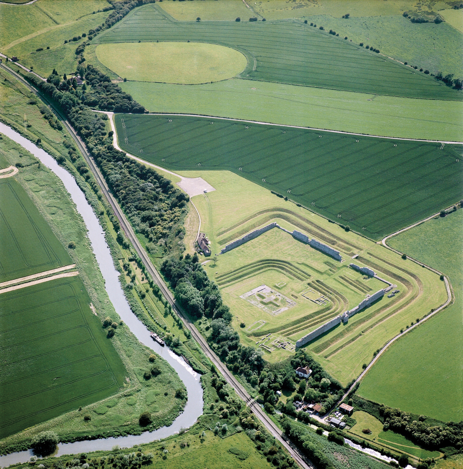
The Claudian invasion is thought to have reached its first landfall at Richborough (Rutupiae) in Kent, which lay at the southern end of the Wantsum Channel, a waterway that separated the Kentish mainland from the Isle of Thanet, allowing sheltered access to the Thames estuary. The invasion bridgehead at Richborough was defended by a pair of long parallel ditches and an earth rampart pierced by a single timber gate. Subsequently, and before the end of the 1st century, Richborough developed into an undefended port town with an amphitheatre, possibly an early construction, on its fringe. Geophysical survey shows that the town eventually covered some 21 ha. At some time between the reigns of Domitian (AD 81-96) and Hadrian (AD 117-138) a huge four-way monumental arch (quadrifons) clad in white Italian Carrara marble, was erected in the town, one of the biggest such monuments in the entire Roman Empire.18 Symbolically located where the conquest began, it functioned as the ceremonial gateway to Britain. Until the late 3rd century Richborough had no known role in coastal defence, serving simply as an open port of entry.19 A Roman road book, the Antonine Itinerary, made under Caracalla (AD 211-217), specifies only one sea route from the European mainland to Britain: ‘from Boulogne of the Gauls to Richborough of the Britains’.20
Figure 2: Aerial view of Richborough, from the north, showing the whole area of the early port town. The oval area in the background is the amphitheatre site.
Credits/sources: Historic England, UK.
The Classis Britannica in relation to the forts
The Classis Britannica, or British fleet, first referred to by name by Tacitus and others during the late 1st century, may have originated in the Claudian invasion fleet. Archaeologically it is only discernible from the late 1st or early 2nd century when its principal bases were established on each side of the English Channel, at Boulogne and Dover.
Boulogne (Gesoriacum) was greatly expanded in the early 2nd century. A new large military installation, a rectangular fortress measuring 400 x 302-303 m (c. 12 ha) and housing 2,000 to 2,500 men, was built under Trajan or Hadrian on the promontory dominating the estuary and fortified port. This port, discovered in 1992, was trapezoidal in plan and was open to the estuary. The fort and port together covered an area of c. 25 ha and were defended by a stone wall. The harbour entrance was marked for shipping by one or two monumental lighthouses. Boulogne became one of the most important places in the north-west Roman Empire both because of its role in military traffic and its perfect location for the control of trade. As the official port to Britannia and the most important fleet base of the Classis Britannica from Claudius onwards, until the middle of the 3rd century, it fell under the administration of the praefectus of the British fleet. At the beginning of the 3rd century, an interruption in the occupation of Boulogne can be attested. Subsequently, part of the barracks was rebuilt, probably in preparation for the Scottish campaigns by Septimius Severus.21
On the British side of the Channel the fleet base was at Dover (Dubris). It took over the function as the official port from Richborough by the end of the 1st or beginning of the 2nd century. The site occupies the only break in a 12 miles stretch of the famous white chalk cliffs, at the mouth of the river Dour, and is on the shortest crossing point from the Continent. Construction of the stone-built fort began around AD 120 and was completed c. AD 130, after a brief abandonment. The Classis Britannica fort II was constructed in AD 130-140 and was occupied during three phases eventually ending around AD 208. The 1.05 ha fort was slightly trapezoid in plan with rounded corners. The principal east gate which faced the harbour was elaborated with projecting D-shaped towers. A large bathhouse was built outside the fort to the North.22 As at Boulogne, the high headlands flanking the harbour were occupied by lighthouses. That on the western side was destroyed in the 19th century, and only a fragment, known as the ‘Bredenstone’, is extant, but the eastern lighthouse or pharos survives within the walls of the medieval castle.23
At both Dover and Boulogne, the presence of the fleet is shown by hundreds of tiles and bricks stamped with the letters CLBR. Such tiles have been found elsewhere around the British coast, including in London, and at Richborough, Pevensey and Lympne, where Saxon Shore forts were later built. From Lympne came an inscription dedicated to Neptune by Lucius Aufidius Pantera, the prefect or commander of the fleet.24 Together with the many CLBR tile stamps, the mention of Portus Lemanis in the Antonine Itinerary of the early 3rd century indicates that Lympne was initially the location of a fleet base of the Classis Britannica.25 Tile stamps have also been found associated with the exploitation of iron in the Kentish Weald, and at a large villa at Folkestone, possibly the residence of the fleet commander.26 Evidence for the fleet’s exploitation of Wealden iron was also found at Beauport Park, Sussex.27 Three inscriptions record detachments of the fleet assisting in the construction of Hadrian’s Wall in the 120s, one at Benwell and two in the Birdoswald area.28 Many inscriptions relating to the fleet have also been found at Boulogne.29
Coastal defence on the continent until the mid-3rd century
The militarisation of the shores of Germania Inferior began in the 2nd century, probably under Hadrian. This development is connected with the evolution of the Rhine frontier and the strategic importance of the Rhine delta region for military transit to and from Britain.
At The Hague-Ockenburg, in the dune area between the Rhine and Meuse estuaries, lay a c. 44 m square fort, a so-called mini-castellum, garrisoned by a small cavalry unit, and dated to AD 150-180.30 Based on tile stamps of the Classis Germanica, finds of military equipment, inscriptions and/or early observations, military installations can also be assumed at Katwijk-Brittenburg, The Hague-Scheveningseweg, Wassenaar-Kleine Pan, Monster-Poeldijk, Naaldwijk, Oostvoorne, Goedereede-Oude Wereld, Westenschouwen-Roompot and Oostkapelle-Oranjezon.31 They formed a line of small fortifications at strategic points along the coast, briefly occupied, others reactivated after time. Coins at Ockenburg and at Scheveningseweg demonstrate occupation as late as the period of the Gallic Empire (AD 260-274).32 From the later 3rd century onwards this area became increasingly wet and though coastal defence was no longer needed, the site of Katwijk-Brittenburg, at the mouth of the Old Rhine, on the old dunes, where a later Roman military installation was situated, may have been retained.33 This site may have been the location of Lugdunum, noted in the Antonine Itinerary, and thus one of the most important places in the province.34
In the coastal region of Gallia Belgica military activity began in the later 2nd century, in response to the increasing pressure of Germanic seaborne raiding in the North Sea. Significant raids by the Chauci, the most frequently named Germanic seafaring tribe at that time, took place in AD 172-174; they may have deliberately by-passed the defended coast of Germania Inferior. These incursions took place during an era already in crisis, marked by economic and financial problems, a devastating plague, significant revolts, increasing tax pressure and military troubles on the Danube and the Middle Rhine.35 Chauci raids are mentioned in the Vita Didii Iuliani,36 as the future emperor M. Didius Iulianus campaigned against them as governor of Gallia Belgica. The raids prompted the construction of an earth-and-timber fort at Maldegem-Vake, located c. 10 km east of Bruges and c. 6 km south of Aardenburg. This fort was discovered through aerial photography only at the end of the 1970s; in the period 1984-1992 c. one third of the fort was excavated. Its occupation by a cohors equitata was only intermittent and dates to c. AD 172-175.37 This reaction makes sense against the background of the severe Marcomannic Wars at the Danube and the heavy invasions by the Chatti at the Middle Rhine; no risks were taken.38
Maldegem was soon succeeded by a fort at Aardenburg,39 which most likely took over its military role, focussing more on the coastline. In the same broad period, somewhat later than AD 180, the first fort was erected at Oudenburg. Both forts Aardenburg and Oudenburg, sited on high sand ridges protruding into and overlooking the coastal plain, and near the end of a navigable tidal natural channel, were earth-and-timber-built. In a region without natural stone sources suitable as building material and with wood, sand and clay amply available, the construction of such forts was a practical choice, unrelated to the character or intended duration of the occupation. That they were closely related is evidenced by similar tile stamps and identical military supply arrangements. The erection of both forts was probably the work of the emperor Commodus (AD 176-192) who strengthened the defences of several frontiers. Though a decline or even interruption in occupation of both forts in the beginning of the 3rd century suggests that their garrisons were withdrawn to join Septimius Severus’ campaigns in Scotland (AD 208-211), both were rebuilt in the third decade of the 3rd century. At Oudenburg a military hospital of that period was uncovered, decorated with wall paintings. The many building phases identified at Oudenburg before AD 260 bear witness to rapid troop movements in a period characterised by civil wars, revolts and battles for the throne.40
The ‘first generation’ shore forts of Britannia
In contrast to the continent, no seaborne raids are attested in Britain, though the three earliest forts situated on the North Sea coast also date broadly to the later 2nd or early 3rd century. These ‘first generation’ shore forts were Brancaster, Caister-on-Sea and Reculver. They may have been prompted by the same concerns as the continental installations, though a connection with the problems in Scotland and the further defence of supply lines during Severus’ campaigns into Scotland in AD 208-211 have also been suggested.41 The latest research at Reculver has put forward a start date in the period AD 185-195 under Commodus, and comparative analysis of the building style of the three forts, their pottery and their coin spectra suggest similar dates.42 A significant coin peak at Reculver points to important military activity in the period AD 222-238. An inscription recording the construction of the headquarters building under governor Rufinus, probably Q. Aradius Rufinus who was later proconsul of Africa in 238, may be related.43 Two of these forts, Brancaster (Branodunum) and Reculver (Regulbium), appear in the Saxon Shore Notitia list and the attribution of Roman names to these places is not in doubt. The third, Caister-on-Sea, is not included, possibly because it was later supplanted by Burgh Castle.
All three forts shared the ‘playing-card’ plan typical of Roman forts of the 2nd and early 3rd century in Britain. They varied only slightly in size, with Brancaster the smallest at 2.56 ha, and Reculver the largest at 3.1 ha. All three had stone outer walls backed by earthen ramparts with internal corner towers and were surrounded by a pair of ditches. The internal layout of Brancaster is indicated by remote sensing, and that of Reculver through excavation. Both had four single-portal gates and, in the rear half of the fort, a headquarters building which was oriented to face the sea. Otherwise layouts were irregular, but included barracks, officer’s quarters and, in the case of Reculver, an internal bathhouse. Only the southern half of the fort at Reculver has survived the ravages of coastal erosion, which was halted by the building of a sea wall in the 19th century.44 The internal layout of Caister is little known, but parts of the south wall and gate, and a single internal building have been excavated. This building, in the South-West quadrant of the fort, boasted heated rooms and painted wall plaster and may have been the fort commander’s house.45
The earliest garrison at Brancaster, attested by stamped tiles from the site, was a part-mounted cohort, cohors I Aquitanorum equitata. By the time of the Litus Saxonicum it had been replaced. The only garrison known from Reculver is named both in the Notitia and on an inscription from the site as the cohors I Baetasiorum civium Romanorum. This unit was previously at Maryport on the Cumberland coast, and may have specialised in coastal operations.46 It seems to have remained at Reculver until the end of the 4th century. No garrison is known for Caister.
This ‘first generation’ defence may have been supplemented by fortified ports at Caister-by-Yarmouth and Brough-on-Humber, by Colchester and Rochester, and certainly by the fleet bases at Dover, Lympne and later the fortified signal-station at Richborough.47 At Richborough, in the middle years of the 3rd century, the quadrifons monument was transformed into a defended lookout post fortified by a rampart and three concentric ditches. These ditches were cut through demolished domestic and industrial buildings in the centre of the town suggesting an urgent military priority.48
It is possible that there was a reorganisation of the naval forces around the mid-3rd century, as there is no later epigraphic or literary reference to the fleet. The latest such evidence is on a tombstone dated AD 244-249 from Arles in southern Gaul (Classis Britannica Philippiana).49 However, the Panegyrici Latini (VIII [V], 12, 1) mention that Carausius fled to Britain (in AD 286) and took ‘the fleet which once guarded the Gauls’, suggesting that the Classis Britannica still existed at the time.50 Nevertheless, the fleet base of Dover had already ceased to exist in the first quarter of the 3rd century, while the barracks of the fleet base at Boulogne seem to have been still in use until at least the end of the AD 260s.51
The impact of increasing threat in the later 3rd century and the ‘developed British forts’
The later 3rd century saw an abrupt change in coastal defence, with the construction of new, stone-built forts on both sides of the Channel and North Sea region. Under the breakaway Gallic Empire of Postumus and his successors (AD 260-274) the North Sea experienced an enormous increase of Germanic seaborne attacks, most of them probably small-scale, though some, like the invasions of AD 260 and AD 268, massive. Various mentions in the Historia Augusta indicate several piracy attacks on the coasts of Germania Inferior and Gallia Belgica.52 Coins hoards dating to AD 260 show a dense concentration in the western provinces of Gallia Belgica, those of AD 268 are concentrated in the coastal plain of north-west Gaul.53 Part of those and later coin hoards may also be related to internal threats though. This increase of seaborne attacks may have been related to the cessation of the organised protection of the North Sea coasts by the Classis Britannica. The AD 268 seaborne attack may have been the cause of the large-scale fire which destroyed the Boulogne military base,54 although there are arguments for an interpretation in favour of a later date.55 As a response to the invasions, the forts of Oudenburg and Aardenburg were rebuilt under Postumus, as part of the Gallic Empire, now with stone defensive walls, emphasising their status and position along the North Sea. They were provided with circular gate and corner at Aardenburg interval towers. The walls were only 1-1.5 m thick and backed with broad earthen ramparts. The wall building technique was strikingly similar, indicating the construction of both forts as part of one building programme. At Oudenburg, the petrification of the fort saw a total renovation of the inner buildings. Of that period, the workshop area was discovered at the south-west corner of the Oudenburg fort during the 2001-2005 excavation campaign. The remains of a rectangular stone building, of unknown function, uncovered in 1977 in the northern part of the fort can also be dated to this period.56 A preventive archaeological excavation in the summer of 2023 in the centre of the fort brought to light the foundations of the corner of the principia of the same period.57 Historic sources and stray finds suggest that in that period a military post was also installed at Watten on the Aa estuary, where the river crosses the Cassel-Boulogne road.58
When Aurelian brought the Gallic Empire under central control in 274 the forts of Oudenburg and Aardenburg remained occupied without interruption. It cannot be claimed that there was a unified cross-Channel command at this time, but the forts on both sides of the Channel seem to have operated in the same way. This cross-Channel connection is evidenced by an increase of British imports to the continental sites, such as Romano-British pottery, whetstones from the Weald, and jet items from the Yorkshire coast.59
Throughout their occupation Oudenburg and Aardenburg seem to have been garrisoned by mixed units of infantry and cavalry, adapted to their role in the coastal defence in intercepting small raids and patrolling the coastline. This is also true of Brancaster, while the Reculver Baetasii may have been coastal specialists.
Along Britain’s eastern and southern coasts, between the Great Estuary and the Wantsum Channel, and from the Wantsum to the Solent, eight new forts were constructed in the later 3rd century: Burgh Castle, Walton Castle, Bradwell-on-Sea, Richborough, Dover, Lympne, Portchester and Pevensey. In literature they are called the ‘developed British forts’. These varied in shape, size, and sophistication, and reflected a significant change in military architecture. The massive outer walls were equipped with external projecting bastions or towers, intended to allow the stretches of the curtain wall between them to be controlled by enfilading fire, a defence specifically designed against the threat of siege. The ways in which these innovations were adopted differ from fort to fort, and there is no standard pattern. Like the earlier group, the forts share a common relationship with the sea, being on inlets or estuaries, lying close to sea level with little distant view over the sea. Siting seems to have been largely geographically rather than strategically dictated, and this has led some to suggest that the forts served principally as defended harbours.60
Burgh Castle (Gariannum) lies on the southern side of the Great Estuary, almost directly opposite Caister-on-Sea. Its elongated trapezoidal plan, of which three sides survive, enclosed some 2.4 ha. There was a central single-portal gate in the east side. The thick walls are faced with split flint blocks interspersed with triple tile bonding courses. Six solid, round bastions survive out of a probable original ten. These were virtually free-standing, bonded with the curtain wall only in the very top courses, and were unsuited to provide enfilading fire along the fort wall face, as they were too far apart. Those at the corners are uncomfortably added to curved corners reminiscent of the earlier ‘playing-card’ shaped forts. A hybrid, its builders may not have properly understood the purpose of the bastions. Little is known of its interior building, partly due to early medieval and medieval reuse and quarrying into the 19th century. Only in the corner areas were traces of buildings uncovered. Based on architectural grounds, the construction of this fort has been dated after AD 260. The fort continued to be in use until a large fire around the middle of the 4th century.61 Inland from Burgh, Roman ceramic building material reused in the walls of Reedham church and possibly originating from a very large Roman building, suggests the location of a fortlet or signal station in this area.62
Walton Castle (Portus Adurni), near Felixstowe, which commanded the estuary of the Stour and the Orwell, was completely lost to the sea. It is known only from antiquarian drawings which show a resemblance to the style of walls and corner bastions of Burgh Castle. Based on the presence of round bastions it has also been dated after AD 260.63 Of the fort of Bradwell-on-Sea (Othona) no standing fabric survives either, as it was totally dismantled during the 17th and 18th centuries and was partly eroded by the sea. From early descriptions and limited excavation, it is known that external bastions were provided on the corners and equidistantly between the corners and a central west gate. An earthen bank was raised against the internal face of the wall, and a wide defensive ditch was provided. The 7th century chapel of St Peter ad Murus built entirely of Roman materials occupies the site of the west gate.64
At Richborough (Rutupiae) the 145 m-square late Roman fort replaced six town insulae. It has been assumed that the town contracted around the fort in the later 3rd century,65 but recent work has demonstrated that the town continued to flourish at its full extent until the very late 4th century,66 and we should therefore assume that the loss of the six insulae was no small matter to the town’s inhabitants. The arch was demolished, and its materials reused; moulded marble pieces may be seen embedded in the concrete, and foundation blocks in the west gate foundation feature bar-cramp slots that do not match. The timber-laced foundations were of stone and rammed chalk reinforced on the east side with timber piles. The 3.5 m wide walls survive in places to a height of 6 m. The layered concrete and rubble core was faced with squared Kentish ragstone interspersed with double tile courses. Putlog holes for the builder’s scaffolding are visible. There was a single portal gate on the west side, and a dog-leg postern on the north. The corners were provided with solid circular external bastions, and hollow square towers were situated between the gates and the corners. Joist holes for timbers of upper storeys in these towers are apparent in the walls. Several internal buildings are known, including a small bathhouse in the north-east corner. A headquarters building may have been built on the site of the quadrifons monument. While c. 60 % of the fort’s interior has been excavated, little stratigraphy of the late 3rd and 4th century survived.67 The east wall of the fort collapsed sometime between the 5th and 11th centuries as a result of marine erosion. Recent research on this eastern side has resulted in a revised plan of the Saxon Shore fort.68
As at Richborough, buildings in the town of Dover (Dubris), including the ‘Painted House’, a high-status town house featuring elaborate murals, were demolished to build the Saxon Shore fort around AD 250-260, which was much larger than its predecessors.69 The fort wall and its semi-circular bastions have been excavated on the southern and western sides. As the only British fort overlain by a modern town, observations have been largely dependent upon development, and include sightings of masonry on the northern and eastern sides. A symmetrical trapezoidal plan with sixteen bastions including four circular corner towers, has been suggested. The wall was backed by an earthen rampart which covered and preserved the ‘Painted House’. Much of the building material was reused from the demolished Classis Britannica fort, and its external bathhouse was retained within the walls of the later fort and continued in use in a reduced form.70
The fort at Lympne (Lemanis) was built on a sea cliff which in Roman times overlooked a major tidal inlet. The fort remains have been fragmented by landslips and stone robbing, leaving tumbled and tilted sections of masonry scattered across the landscape. Reused masonry seems to confirm that there was an earlier installation, probably associated with the Classis Britannica, already suggested based on the tile stamps and the mention of Portus Lemanis in the Antonine Itinerary (see before). Geotechnical evaluation of the landslip pattern suggests an irregular pentagonal plan enclosing some 3.4 ha.71 Excavation has located a single-portal east gate with flanking bastions and guard chambers and shows the walls were 3.9 m thick at the base, and in places survive to a height of 6 m. Apart from research on the defensive wall, also part of the fort precinct with the presumed principia with sacellum and the baths were located. The fort can be dated from the end of the 3rd until the middle of the 4th century.72
The remaining two south coast forts, Pevensey and Portchester, are the most architecturally developed. Both survive to an impressive degree, with walls preserved in large part to their full height of 6 to 8 m. Pevensey (Anderida), the largest of the British Shore forts, is a 4 ha irregular oval, shaped to fit the promontory on which it stands. About two-thirds of the circuit survives; the southern side is eroded by the sea. The flint core of the wall is faced with squared sandstone with bonding courses of tile or narrow sandstone slabs. In places the work of different work gangs is apparent, and this is also true at Richborough and Portchester. The towers, of which ten survive, placed at irregular intervals but concentrating at the ‘ends’ of the oval, are solid. Like Richborough, there is evidence for timber lacing and piles in the foundations. The principal west gate was set back between two towers, and there were also posterns to the north and east. Only a few small trenches yielded some features and structures of the inner buildings.73
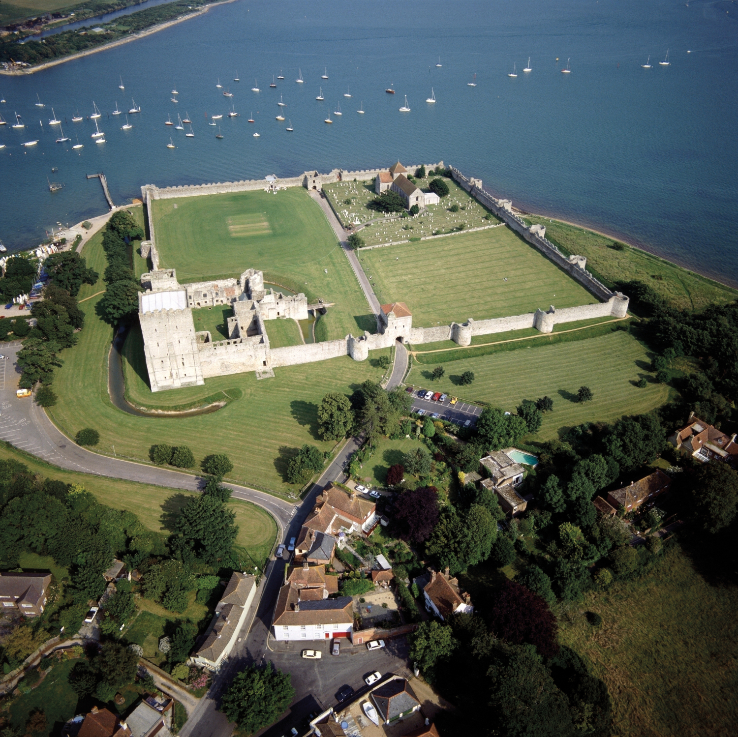
The 3.4 ha square fort enclosure of Portchester (?Portus Adurni), situated at the head of Portsmouth harbour, is the best preserved of the Shore forts and the best-preserved example of later Roman military architecture north of the Alps. The Roman fabric is flint-faced with bonding courses of brick or flat stone slabs. The foundations were timber-laced, and the 3.8 m thick walls survive 6 m high around the entire circuit. There were two major gates on the western landward and eastern seaward sides, and postern gates in the north and south walls. The gates were placed centrally in the walls and twenty hollow ‘U’ shaped towers are evenly situated around the circuit. According to Cunliffe, Portchester may have been built to serve as home base of a naval detachment patrolling the Channel in interaction with its Gaulish counterpart, possibly the unknown Grannona, maybe located near Bayeux.74
Figure 3: Aerial view of Portchester.
Credits/sources: Historic England, UK.
After AD 270 Bitterne (Clausentum), on Southampton Water, was fortified with a defensive stone wall and bastions and its occupation continued well into the 4th century, though it is uncertain whether this was a fortified site or a shore fort.75 The siting of a fort at Bitterne may have been intended to counter any attempt by Constantius Chlorus to regain the British provinces by means of a crossing to Portchester.76
All these shore fortifications in Britannia may also have been complemented by fortified cities at Canterbury, Colchester, Rochester, Chichester and London. It is possible that Voorburg (Forum Hadriani) in Germania Inferior and Cassel in Gallia Belgica also fulfilled such a role.77
Carausius and the chronology of the British forts
In 285 Diocletian’s imperial colleague Maximian granted the Menapian officer, M. Mauseus Carausius, a commission “at Boulogne to pacify the sea, which the Franks and Saxons were infesting throughout the regions of Belgica and Armorica” (Aurelius Victor, XXXIX, 20: propulsandis Germanis maria infestantibus; Eutropius IX, 21).78 This suggests that the raiders had already broken through the Boulogne-Dover defence and had reached the coasts of Armorica, current Brittany.79 In AD 286, suspected of colluding with the pirates, Carausius was sentenced to death by Maximian. In response he “stole the fleet that used to protect Gaul”, added many more ships, declared himself emperor and established an Imperium Britanniarum over part of the coastal region of northern Gaul and the whole of Britain, with Boulogne as his fleet base.80 The excavations at the Oudenburg and Aardenburg forts evidenced that they formed part of the official Roman Empire.81
During this period the North Sea still suffered from Frankish incursions. Maximian’s victory against ‘barbarians’ in AD 288 is recorded in literary sources. From one of the Panegyrici Latini (VI [VII], 5) it is known that Constantius Chlorus, then Caesar in the western provinces, purged the area between the Scheldt and the Rhine from Franks in the period 293-297.82 Around AD 290/300, the occupation of the Oudenburg and Aardenburg forts came to an abrupt end, marked by fire layers, perhaps following one of these Frankish invasions. It was the end of the military occupation at Aardenburg, though Oudenburg played again a major role in the North Sea region in the 4th and early 5th century.83
Also in AD 293 Constantius Chlorus recaptured Boulogne and presumably all of Carausius’ continental possessions. At about the same time, Carausius was assassinated by his finance minister Allectus, who took over his title. In AD 296 Constantius Chlorus invaded and recaptured the British provinces.84
The quality of evidence for the construction dates of the developed British shore forts varies. At Pevensey a combination of dendrochronology, and the presence of coins of both Carausius and Allectus in the foundations, give an “unequivocal terminus post quem of AD 293” for its original construction.85 At Richborough the triple ditches around the quadrifons were backfilled in preparation for the fort’s construction after c. AD 273. While construction deposits contained no Carausian coins, the earliest occupation layers contained many, suggesting building took place between c. AD 273 and the earliest years of Carausius’ usurpation.86 At Dover the ‘Painted House’ was occupied until c. AD 270-280, after which it was sealed by the fort rampart.87 Stratified coinage at Portchester indicates construction under Carausius c. AD 286-290.88 Bradwell, Burgh and Lympne can be dated after c. AD 260 on architectural grounds.89
The ‘transitional’ plan of Burgh and the apparent pre-Carausian start date at Richborough seem to indicate a construction programme beginning shortly before the usurpation by Carausius. This was continued, massively expanded and accelerated by Carausius and later Allectus, particularly by the building of the British south coast forts. While a construction date under these usurpers can no longer be argued for all these forts, it is clear that they functioned as important elements in a defensive strategy. For the ten years from AD 286 to 296 these forts were a bulwark against the expected reconquest and the capacity of Roman forces to conduct siege warfare. Uniquely, this was a Roman frontier against Rome.
Figure 4: The three pages of the Notitia dignitatum on which the commands of the Litus Saxonicum are listed.
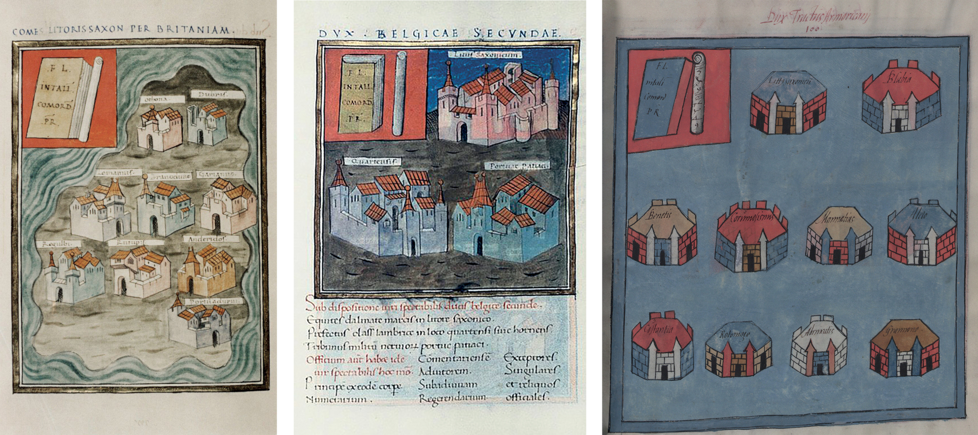
Left: the page in the Bodleian manuscript of the Comes Litoris Saxonici per Britanniam (Notitia dignitatum, West, XXVI). Middle: the page in the Bodleian copy of the Dux Belgicae Secundae (Notitia dignitatum, West, XXXVIII). Right: the page in the Munich manuscript of the Dux tractus Armoricani et Nervicani (Notitia dignitatum, West, XXXVII).
Credits/sources: Left: Oxford, Bodleian Library, Canon. Misc. 378, fol. 153v. Middle: Bodleian Library MS. Canon. Misc. 378 fol. 164r, Oxford/UK. Right: Munich, Bayerische Staatsbibliothek, Clm 10291, fol. 89.
Unification into the Saxon Shore
In the Notitia dignitatum, nine British forts appear under the ‘Count of the Saxon Shore in Britain’ (Comes Litoris Saxonici per Britanniam).90 These can be identified with the forts at Bradwell-on-Sea (Othona), Dover (Dubris), Lympne (Portus Lemanis), Brancaster (Branodunum), Burgh Castle (Gariannonum), Reculver (Regulbium), Richborough (Rutupiae), Pevensey (Anderitum) and Portchester (?Portus Adurni). However, the current research considers at least twelve forts as ‘Saxon Shore’ forts, of which Bitterne, Caister-on-Sea and Walton Castle seem to be the ones missing in the Notitia (unless Walton Castle may be identified as Portus Adurni).91 As outlined above, these forts were erected at different times for different reasons. Like the contemporary continental forts, the early group was probably built against threats from overseas, while some of the developed British forts seem to have been erected to counter Roman re-invasion. The grouping of these installations of diverse origins under a single command suggests a further change in the defensive stance of the south and south-east coasts possibly matched further north by the late 4th century construction of a chain of fortlets along the North Yorkshire coast, and prompted by an increased threat from sea-raiders. Symonds has noted that the Yorkshire installations, together with a site on Alderney in the Channel Islands, were of the most militarily sophisticated form in Britain, and argues that they were the building blocks of a new command. However this may be, they do follow the pattern long established of adding to and developing coastal defence according to circumstance.92 The fort of Brough-on-Humber most certainly played a naval role through the early and mid-4th century.93
The origin and scale of the command is disputed. It may originate in the early 4th century as suggested by several scholars;94 all that is certain is that it predates the compilation of the Notitia dignitatum. The fact that the British garrisons were under a Count, higher than a Duke in the late Roman Empire, indicates the importance of the British command, and it has been suggested that its remit was originally broader, possibly including the continental coast.95
On the continental side the Notitia lists three forts under the Dux Belgicae Secundae, the command of the province of Belgica Secunda: Marcis in litore Saxonico; in loco Quartensi sive Hornensi; and Portu Aepatiaci.96 The mention of their respective units—equites Dalmatae, classis Sambrica and milites Nerviorum—makes clear that the coastal defence of the 4th century was a joint effort of fleet, cavalry and infantry. The locations of these sites are poorly understood due to a lack of archaeological evidence; the discussions are illustrative for the critical enquiry to which the interpretation of names and places listed in the Notitia is subject to. Marcis, situated ‘on the Saxon shore’, was probably Mardyc, Marck or Marquise, but this is purely based on etymological grounds.97 The loco Quartensi sive Hornensi refers to two related bases for the Classis Sambrica, one of the flotillas created under Diocletian or Constantine. Cap Hornu and Le Crotoy at the mouth of the Somme have been considered candidates, as has Etaples more to the north, where tiles stamped CLSAM suggest the presence of this fleet, and where a 4th to early 5th century graveyard has a military character.98 But also Quentovic and Watten have been considered as possible locations for this fort.99 Portus Aepatiacus, clearly a port location, has been suggested for Oudenburg, Boulogne-sur-Mer, Audisque near Boulogne, Isques, Etaples and Le Tréport.100
The Rhine delta remained the north-western border of the Empire in the 4th century, as can be deduced from the limited archaeological evidence. Tangible proof of the existence of 4th century forts is only available for Utrecht,101 and further upstream at Meinerswijk, Castra Herulis, Maurik and Driel.102
Under the Dux tractus Armoricani et Nervicani, in charge of the shores of Normandy and Brittany, ten fortified sites are listed.103 Most of them have been located, although hard evidence is often lacking, and some are situated more southwards: Blaye (Blabia); Nantes (Mannatias); Vannes (Benetis); Brest (Osismis); Alet (Aletum); Rouen (Rotomago); Avranches (Abrincatis); and Coutances (Constantia). Two sites remain enigmatic, Grannona in litore Saxonico and Grannonum, and it is uncertain whether these are different locations or the same place. Several identifications have been suggested—Carteret, Granville, Port-en-Bessin, Le Havre, Bénouville and Cherbourg—based on their strategic locations and/or the presence of late Roman remains.104
It has been argued that, because the sites placed first in the two continental lists were named as in litore Saxonico, all the units in these groups belonged to a Saxon Shore structure under the Count.105 Alternatively, an original Saxon Shore command may have included Marcis and Grannona, which fell under the command of the relevant Duces when the command was split. The use of the term on both sides of the Channel suggests that at some time and in some way these forts were used in partnership with those on the British side in combating barbarian raiding, though how this might have worked, given communication difficulties, is yet to be satisfactorily explained.
Of the archaeologically attested continental forts, Oudenburg was the most northerly except for the presumed late Roman military installation at Katwijk-Brittenburg, which is known only from antiquarian sources. The Oudenburg stone fort was renovated and reoccupied in the period AD 325-330, a date established by dendrochronology, coin and pottery evidence, during the large-scale excavations of the first decade of the 21st century, which have refined the fort chronology. The excavated south-west corner of the fort yielded the remains of a bathhouse of that period, decorated with marbles and statuettes. Semi-circular interval towers were added on the north wall, not only offering extra protection facing the enemy, but also symbolising more power and more authority. These intermediate towers at Oudenburg emphasize the close resemblance of this fort to the second generation of the British forts built after AD 260 which were systematically equipped with similar interval towers. The renovation of the Oudenburg fort under Constantine in a way which visually and strategically mirrors the manner in which the British Shore forts were reinforced, seems to testify to a general building programme along the North Sea and Channel. Moreover, it is a valid hypothesis to suggest that the firmly established start date of c. AD 325-330 for this new fort may well represent the actual start of the Saxon Shore system operating under one command.106
From the AD 340s onwards, there are references to increased threat and severe invasions in the region. Maternus for example mentions in his work of 346 that crossing the Channel was a “precarious undertaking because of the presence of barbarians”.107 Both Portchester and Pevensey were renovated in the period AD 340-345.108 Oudenburg retained its importance until around AD 360, or somewhat later, after which occupation was interrupted. In the 360s or early 370s, the army unit of the Oudenburg fort might have been pulled away, as part of the troop movements to the east by Julian in 361 or, perhaps more likely, those by Valentinian in the 370s. In AD 380, also established by dendrochronological date, the fort was reoccupied possibly under Magnus Maximus who withdrew troops from northern Gaul for his war against Gratian. It is believed that he manned the military bases in question with ‘Germanic’ units. From the evidence from the related graveyards at Oudenburg in combination with the finds at the fort interior, it is believed that a non-regular unit occupied the fort from this period onwards. This may imply that if the Oudenburg fort had been part of an integrated Saxon Shore system before, it was no longer, and presumably neither was the whole northern part of Belgica Secunda. It also means that, if the Notitia dignitatum lists the situation of the late 4th century, Oudenburg cannot be identified as Portus Aepatiacus and that this concerns a site more to the south in Belgica Secunda.109
South of Oudenburg the coastal defence of Belgica Secunda is little known. One of the flotillas installed under Diocletian or Constantine to protect the Gaulish coast, was most likely active at Boulogne during the 4th century. Very little is known about the interior of the fortress, apart from some barracks of the retentura and road segments. Military graveyards in the vicinity point to important military activity during the 4th century and the presence of regular units of the land army.110 It is accepted by many scholars that Boulogne does not occur in the Notitia. However, since recent research suggests that Oudenburg cannot be Portus Aepatiacus, it is certainly a possibility to consider that Boulogne with its port is named here.
Except for Boulogne, only the presumed forts at Watten and Etaples are known. Further south, forts or fortlets can be supposed at the strategic locations of Vron, Nouvrion-en-Ponthieu and Nempont-Saint-Firmin, all of which yielded late Roman cemeteries containing graves with military objects such as crossbow brooches, military dress elements and other exceptional items.111
In the 4th century, the northern military organisation of Gaul focused more and more on the defence of the interior, behind the coastal forts.112 In northern Gaul fortified cities, castella and watchtowers were built at different times in the hinterland and along the Boulogne-Cologne road, probably as responses to specific threats.
The militarisation of the coastal regions of the western Gallic provinces—current Normandy and Brittany—and the domain of the Dux tractus Armoricani et Nervicani, only took place in the late Roman period, certainly from the second half of the 4th century onwards, perhaps somewhat earlier.113 Most of the identified Notitia sites were fortified cities and towns, though two of them, Cherbourg—only occupied from the last decade of the 4th century onwards—and Brest, may have been forts. Military finds and two cemeteries indicate that Bayeux must have been an important location, perhaps Grannona. Next to the fortified site of Alet, a fortlet was situated in the bay of Solidor, and on the Isle of Alderney there was a fortlet whose plan is like those of the Yorkshire coast.114
4th century fort life
Evidence for the character of occupation through the 4th century and beyond is sparse due to limited excavation. At Burgh, traces of timber buildings have been found in the corners of the fort close to the walls.115 At Pevensey, traces of hearths, probably associated with timber buildings, were found in the north-west corner, and a coin of AD 330-335 found in a beam hole under the wall seems to indicate a major repair.116 At Portchester was a grid of gravel-surfaced paths, together with wells and pits, representing several phases of occupation. After c. AD 365 occupation is described by the excavator as disorganised.117 At Richborough, a Christian church is evidenced by the presence of a tile-built baptismal font, and at least one stone-built structure dates to this fort period, though it is difficult to allocate buildings to this period with confidence.118 At Brancaster, geophysical survey shows an extensive extramural settlement, and the same may be true of Burgh.119 Elsewhere there is little evidence for such settlements. The Oudenburg fort retained higher status structures until c. AD 360, with the internal bathhouse being furnished with marbles and statuettes. The occupation from 380 onwards clearly shows a different character, with a bathhouse left unused and replaced by a stable and other enclosures for livestock.120
Forts on both sides of the Channel have produced complementary material assemblages. No late cemeteries have been located in Britain associated with Shore forts, but there are several on the continent. Evidence for military occupation in Britain is sparse, but includes weapons, and a near-complete late Roman helmet from Burgh.121 Three inhumation cemeteries have been found at Oudenburg, with many burials containing late crossbow brooches, an important insignia of high military rank. Graveyard A, at c. 400 m to the west of the fort, comprising 216 graves of deceased fort inhabitants of the second quarter and middle of the 4th century and the late 4th-early 5th century, yielded the largest assemblage of late crossbow brooches known in the North-West, underlining the importance of this fort.122 Such brooches and other elements of ‘official’ dress, like belt fittings, have also been found on British sites. At Oudenburg and Portchester women’s and children’s shoes found largely in wells, together with other objects such as jewellery, point to the presence of families in the forts from the late 3rd century onwards.123 The find at Oudenburg of a breast-pump and several bones of neonates and foetuses are illustrative for family life within the fort walls.124 Industrial evidence, particularly for metalworking, leather working, spinning and weaving, bone and antler-working, and butchery and meat processing, has been found at several sites.125
At Oudenburg the fort community from c. AD 380 onwards appears to have been ‘Germanised’ or ‘culturally Germanic’, whether the inhabitants were all ethnically Germanic or not. By that time, in this frontier region, new military communities had been formed through a long history of incomers, forming a different sociocultural context, whilst still a very well-organised military community. An ingenious filtering system within a reactivated well together with continuing large-scale trade—including cross-Channel—are only two examples of this at Oudenburg.126
Figure 5: The city centre of Oudenburg. The square street pattern outlines the Roman fort with its central axes.
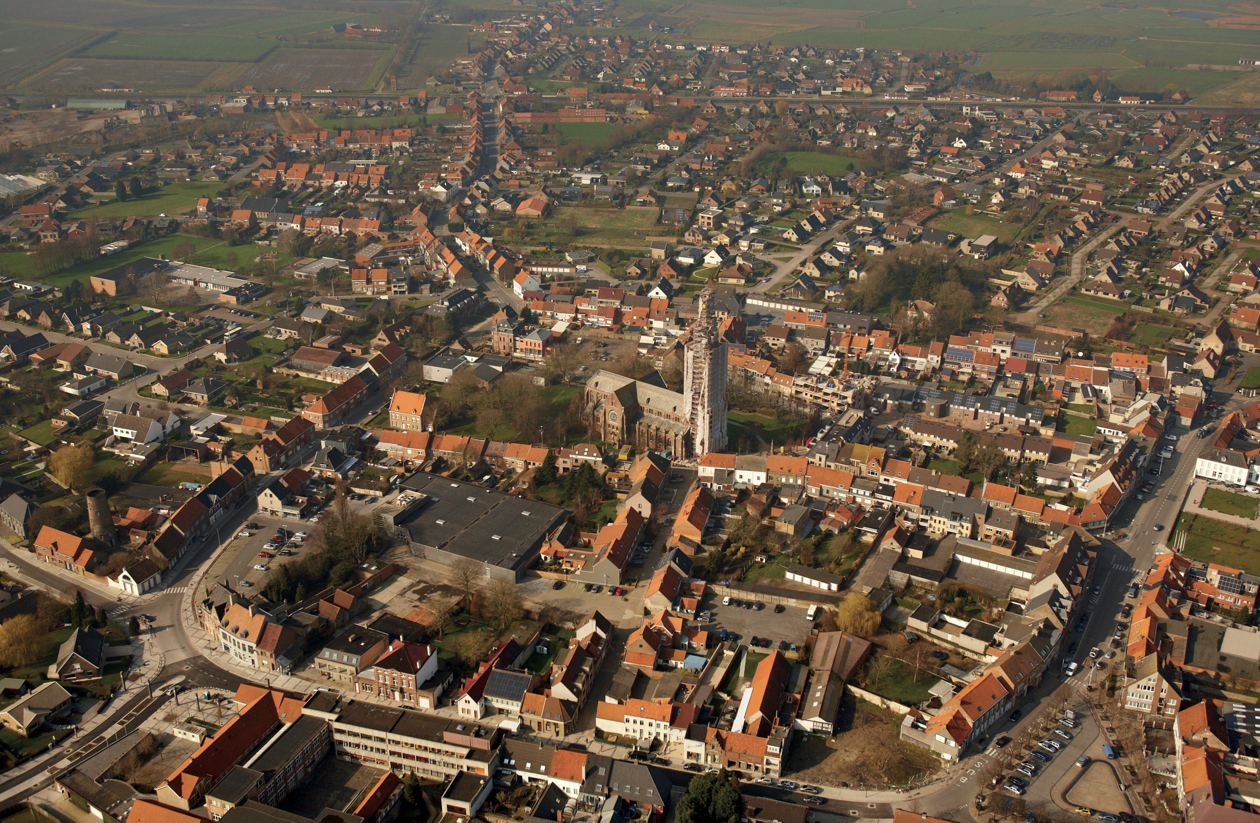
Credits/sources: Flanders Heritage Agency, Belgium.
The end of the Litus Saxonicum
If evidence for the occupation of the forts is sparse, evidence for their end is still more so. Lympne, Reculver and Burgh may have been abandoned before the end of the 4th century, Lympne presumably around AD 348, due to silting,127 Burgh Castle probably also around that period,128 while at Reculver occupation seems to have ceased around AD 375.129 Brancaster and Caister-on-Sea functioned until the end of the 4th century, while late coins, including coins of Arcadius (AD 383-408) and Honorius (AD 393-423) at Dover and Portchester suggest military occupation into the 5th century.130 At Richborough, amongst the 4,000 mainly unstratified Theodosian coins four later coins of at least well into the second quarter of the 5th century have been discovered.131 Moreover, recent work at Richborough has shown that the town on which the fort was imposed continued to flourish to its full extent into the late 4th to 5th century.132 For Pevensey a continuation of the fort occupation has even been suggested until around AD 470.133 Continued fort occupations do not of course suggest that any unity of command continued to exist, and it is impossible to judge the longevity of the command of the Litus Saxonicum. Indeed, the suggestion that this command existed as one phase in a series of ad hoc developments might argue for a short life.
It is no longer generally accepted that northern Gaul and Britain fell out of Roman control after the barbarian invasions of AD 407 or the suppression of the British usurper Constantine III in AD 411. It is however very difficult to know what happened from that time onwards. While it is difficult to pinpoint the exact end of Roman occupation on the Gallic coast, the evolution of the region in general suggests the fort communities gradually lost their Roman military character and may have evolved into ‘warbands’ in the first decades of the 5th century, in analogy to what has been proposed at Hadrian’s Wall.134 Through an analysis of distribution patterns of coins, belt-fittings and crossbow brooches in south and south-east Britain it has even been suggested that this assumed evolution of fort garrisons into warbands commanded by ‘warlords’ may already have started in the last quarter of the 4th century.135 Finds at Richborough bear witness to a violent end, which recently has been believed to have happened only by the middle of the 5th century.136
Conclusions
The policy of coastal defence from the North Sea through the English Channel during the Roman period constantly altered according to the intensity and change of external maritime threat. Each of these changes left their archaeological mark in the disposition of military sites. The probable evolution of the Classis Britannica from the Claudian invasion fleet left two fleet bases at Dover and Boulogne, which featured conventional playing-card shaped Roman fort plans. It is significant that through the 1st to the mid-3rd century the invasion site at Richborough developed into a large and prosperous undefended fort town adorned with an imperial monument. There is no sign here that any maritime threat was anticipated. This sits in contrast with the development of militarisation of the Rhine delta during the Hadrianic period and the subsequent defensive activity on the Gallic coast in the later 2nd century in response to Germanic raids, and the flurry of changes in the late 2nd and early 3rd century attested at the fort of Oudenburg.
Although the three ‘first generation’ shore forts on the British North Sea coast may have been built in response to similar threats to those affecting the continental coast, their date also suggests a context connected with the defence of the supply lines to Severus’ campaigns in Scotland, although these two explanations are, of course, complementary, as any threat to supply lines would be likely to come from the very groups who were active in the assaults on the Germanic and Gallic coasts.
Through the first half and the middle years of the 3rd century, the evidence suggests a growing insecurity on both sides of the water. This resulted eventually in the construction of large stone forts, in Gaul at Oudenburg and Aardenburg under Postumus, and along the coasts of Britain, where the ‘developed shore fort’ building programme took place. The dating evidence for the developed forts, though varied in quality, all points to construction broadly in the 260s and 270s. It seems that the building programme was a matter of military urgency. This is suggested by the fact that the new fort at Richborough was built using the material of the demolished great quadrifons arch, and that the construction was at the expense of six insulae of the port town. The loss of these insulae must have been no small matter to the town’s inhabitants, as recent work has yielded evidence for a full extent of the town until the very late 4th century. The same military priority is also evidenced by the demolition of the ‘Painted House’ in Dover and its burial under the fort rampart. This building programme must have been a strategic response to threats from the North Sea.
It is important to note that the construction phases at Richborough did not contain coins of Carausius, while the occupation levels did. This shows that the usurpation (as the literary sources imply) took place against the background of increased raiding. The fact that the forts at Pevensey and Portchester were built during the usurpation, that they are the most sophisticated of the series, and in particular that Portchester is so far west, and located in a position to deny access to the excellent harbour of Portsmouth, would perhaps suggest that, though an extension of the continuous defensive scheme, they were located to counter any attempt by Constantius Chlorus to regain the British provinces by means of a flanking crossing to known harbours from the west. The position of Bitterne on Southampton Water may suggest the same.
As demonstrated above, the Litus Saxonicum command recorded in the Notitia must have summarised a military reality that existed at some time prior to the compilation of the document, however, the installations in Britain that fell under that command originated in three phases of coastal defence: the primary forts of the early 3rd century, the main body of the developed forts against increased raiding, and a group of forts built specifically to counter Roman re-invasion. Far from being a coherent group, these forts appear to have been conveniently brigaded under a single command, which also included some installations on the continental mainland. The date at which this command was established is uncertain, and it is possible that the united Litus Saxonicum command was not long-lived. The Notitia records an office that existed for a period within the pattern of constant change of threat and response, which continued throughout the 4th and into the 5th century but separated into discrete commands either side of the Channel. It is significant that the majority of forts of the Litus Saxonicum, whether in Britain or on the continental mainland, have not had the benefit of extensive periods of archaeological excavation, and this has hampered interpretation of the wider system. Sites with more intensive and/or extensive excavation, especially from campaigns in more recent years as at Richborough and Oudenburg, have yielded new data and better resolution relative to phasing and dating that has provided invaluable insights to the wider military archaeology of the Litus Saxonicum.