The Rhine: Rome’s preordained frontier1
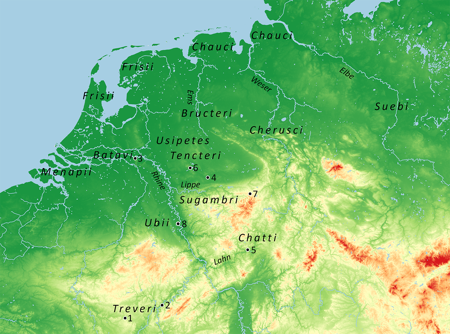
In the opening of his account On the war in Gaul, Julius Caesar famously presented the river Rhine, “exceedingly broad and deep”, as the natural dividing line between the more culture-susceptible peoples of Gaul and the inveterately warlike Germans.2 The reality, of course, was more of a cultural and political continuum, certainly in the Lower Rhine region, as the contemporaneous triquetrum coinages illustrate.3 Caesar himself was well aware that “most of the Belgae were of German origin” and that several tribes living on the left bank of the Rhine were in fact German.4 The Treveri likewise claimed a German origin and regularly tried to involve groups across the Rhine in their resistance against Caesar.5 But despite all those cross-river links, in the context of the subjugation of Gaul, the Rhine, given its geographical position, was destined to impose itself as the mark of Roman dominion. From the start Caesar had made clear, to Ariovistus in 58 BC and to others later, that Rome’s ordering power was to be understood as extending up to the Rhine—and beyond, if Roman interests were at stake.6 Interestingly, some of the troublemakers on the right bank, like the Sugambri, reverted to the same rhetoric if it suited their cause, proclaiming that “the Rhine marked the limit of the Roman Empire”, and Caesar should not interfere with them.7 The Menapii had used the river to separate themselves from the wandering Usipetes and Tencteri and, for some time successfully guarded it as a defensive obstacle.8 The Rhine was the inescapable dividing line of hegemonic rhetoric and territorial claims. Caesar’s massacre of the Usipetes and Tencteri, somewhere in the Dutch river area, left no room for mistake about who ruled the river’s left bank.9
There can be no doubt that, by the start of the imperial period, all land and population up to the Rhine counted as subject to Rome. When the Treveri rebelled in c. 30 BC, they were duly suppressed by M. Nonius Gallus, resulting in Roman garrisons being placed in their oppidum on the Titelberg and at Trier-Petrisberg.10 A decade later, in 19 BC, Augustus’ mainstay Agrippa was sent to Gaul. It must have been under his governorship that a road was constructed via Trier up to the Rhine,11 and a large fortress built at Nijmegen, apparently receiving troops earlier housed at Trier-Petrisberg and/or the Titelberg.12 It was probably now that the Ubii were transferred to the left bank of the Rhine.13 If so, the Batavi are likely to have been part of the same package.14 Based on early Roman coin distribution, Nico Roymans has recently argued that ethnic recruitment in the Batavian area started around 20 BC.15 The new fortress at Nijmegen was superbly placed to keep watch over Agrippa’s arrangement: it was situated close to the soon-to-be-developed civitas capital Oppidum Batavorum, while occupying, from the Roman perspective, the most advanced plateau to overlook the potential landing grounds of incursions coming from the North-German plain. “Agrippa’s decision reflects a new policy, intended to reduce the Suevic pressure on the Rhine-Weser-Germans and to install in the periphery of Gaul, where habitation was probably drastically thinned out by Caesar’s merciless actions, a population loyal to Rome and with a personal interest in preventing new raids or migration attempts.”16 The Rhine was to be Gaul’s boundary and bulwark.
A greater-German province?
Shortly after Agrippa’s settlement, in 17 or 16 BC, the Usipetes, Tencteri and Sugambri again crossed the Rhine and inflicted a painful defeat on the governor Lollius, taking the eagle of the Fifth Legion.17 The impact of this event on Augustus’ German policy has been questioned,18 but its resonances in the court poets suggest serious agitation in Rome,19 and there is a coherent logic in what we see unfold in the following years. In 16 BC, Augustus came over to Gaul,20 to stay there for three years. By then, or shortly after, an offensive policy had apparently been decided for the Balkans, the Alpine region, and probably Germany as well. While the governor of Illyricum, Silius Nerva, annexed Noricum, Drusus and Tiberius campaigned in the Alps in 15 BC, thereby improving Roman access to the wider German theatre, with a first base planted at Dangstetten, across the Rhine. The Balkan project appears to have been considered the toughest job, as Agrippa was appointed to Illyricum in 13 BC, with Tiberius and Drusus probably tasked with Germany.21 During his three-year stay in Gaul, Augustus certainly oversaw the process of Gaul’s further administrative incorporation, culminating in the inauguration of the altar of Rome and Augustus at Lyon in 12 BC. However, this did not prevent preparations for major operations across the Rhine, whatever the precise objective at that point. The scale of Drusus’ campaigns from 12 BC on was such that a rough two-year rule of thumb for logistic build-up in case of major operations22 must have applied in this instance too, certainly when venturing into Germany which was not known for its abundance in harvests and other provisions.
The ever troublesome Sugambri appear to have been one of the prime targets of Drusus’ first trans-Rhenish manoeuvres in 12 BC.23 However, this does not mean that the German adventure started off unpremeditated, as a punitive campaign. Interestingly, Drusus first had to act, militarily it appears, against the tribes that were placed on the left bank of the Rhine, likely including the Ubii and/or the Batavians.24 The operations later in the season targeted the Frisians, the Chauci, and, probably, the Bructeri in the North-German plain and coastal area.25 This was clearly something more than punishing the Sugambri and their usual allies, the Usipetes and Tencteri. The 12 BC campaign, which included major waterborne operations, would normally have required wide-ranging logistical preparation. It is difficult, and unnecessary in light of a close reading of Cassius Dio,26 to imagine this coastal campaign as a spontaneous action, carried out with a motley collection of vessels requisitioned here and there.27
From the start it was clear that Drusus’ campaigns were about establishing a permanent presence. He imposed a tax in kind on the Frisians28, probably in 12 BC, while the fortress whose construction started at the end of the next campaigning season, Oberaden,29 was clearly intended to last, initially perhaps as a stronghold to keep in check the Sugambri. It had an unlocalised counterpart in the territory of the Chatti.30 But Drusus’ aims went much further: the 11 BC campaign had also targeted the Cherusci and would have crossed the river Weser, Cassius Dio reports, had the supplies not been depleted.31 The campaigns of 10 and 9 BC appear to have focused on the tribes living in the Mittelgebirge north of the Main. In 9 BC, Drusus attacked and pillaged the Chatti, Suebi, and Cherusci. He finally reached the Elbe, and made a failed attempt at crossing the river, placing trophies on its left bank as a replacement.32 At some point, the Elbe (pretty much the end of the known world)33 must have suggested itself as a natural limit. Conquering this vast space also meant subjecting the Suebi, the long-standing troublemakers in the Germanic background.34 A planned new campaign via the northern coastal waters and river mouths is implied if Tacitus is correct about the date of the groyne that Drusus had begun constructing at the bifurcation of the rivers Rhine and Waal, its purpose being to divert more water to the former and thereby to the river Vecht, the crucial connection to the north German coastal waters and river mouths.35 Following the unexpected death of Drusus, Tiberius in 8 BC was able to traverse most of Germany without much resistance.36 In AD 5, while restoring order after the somewhat mysterious immensum bellum, he campaigned victoriously up to the headwaters of the Elbe, leaving nothing to be conquered, according to his sycophant Velleius, save the Marcomanni in Bohemia.37 In his political testament, Augustus duly claimed to have pacified Germany up to the Elbe.38
In the western core area of the conquered territory, broadly defined by the rivers Lippe and Lahn, a process of provincialisation had started well before the beginning of the common era. For all its military appearance, the pioneer town of Waldgirmes was clearly intended as an administrative centre, its forum adorned with imperial statues.39 Its foundation followed within a few years after Tiberius’ triumph of 7 BC, which had marked the successful conclusion of the German war, and there may have been others.40 At Haltern, the excess of residential buildings suggests the presence of high-ranking individuals involved in not just military but administrative tasks.41 Its monumental burials are unparalleled in early Roman military contexts.42 At Brilon, in Sauerland, lead extraction was soon organised on an industrial scale.43 By AD 9, a Cheruscan, Segestes, was officiating as the priest of an altar at Cologne—the German counterpart of Lyon.44 This was a province in the making—a province that apparently was to include the Ubii and other German tribes on the left bank of the Rhine, where winter bases for the army had also been established.45
The integration process was shattered by the annihilation of Varus’ army in the Teutoburg Forest in AD 9. This event has often been framed as the turning-point of Augustus’ German policy, but it was not. Rome had never surrendered territory it had claimed as subjected, let alone a province that had existed for over a decade.46 Reversals had always been won back, no matter the cost. Pannonia had just been brought back into the fold in a series of hard-fought campaigns after the revolt of AD 6. Following the Varian disaster, new units had been raised and Tiberius sent to the Rhine immediately, first to restore order on the left bank. Joined by Germanicus, he crossed the Rhine in AD 11 followed by fleet expeditions and ground troops.47 Soon reconstruction appears to have started at Waldgirmes.48 In 13, Augustus, Tiberius, and Germanicus seem to have taken a joint imperial acclamation, suggesting substantial success on the battlefield.49 In the same year, Germanicus was appointed as commander of the forces on the Rhine, totalling eight legions, about a third of the Roman army. When Augustus was revising the text of his Res gestae in the summer of 14, he must have felt confident that the final pacification of Germany up to the river Elbe was on its way.50 It is this river Augustus must have had in mind when he gave Tiberius the famous injunction ‘to keep the Empire within its (present) boundaries’ (consilium coercendi intra terminos imperii).51
Tiberian stasis?
After the campaign of AD 16, Germanicus was summoned back to Rome. Tiberius gave various reasons for his decision, but concealed the most pressing one: fear of his adoptive son’s popularity.52 Following the death of Augustus in 14, the Rhine army had rebelled and wanted to proclaim Germanicus as emperor. In contrast to Tiberius, both Germanicus and his wife Agrippina had a bloodline with Augustus. A resounding victory in Germany, which seemed imminent after the AD 16 campaign, might have seriously endangered Tiberius’ position. In 17, a special senatus consultum carefully curtailed Germanicus’ powers for his new eastern command, showing that Tiberius was fearful of his nephew’s popularity and dynastic position.53 Other factors must have played a role. Costs may have been weighed against benefits, like Strabo did at much the same time for Britain in a detailed calculation, perhaps reflecting imperial policy.54 On a more structural level, it has often been observed that Germany, lacking proto-urban settlements and other fixed assets, was a less easy prey for the proven Roman methods of subjection.55 Perhaps, in retrospect, the whole Augustan project in Germany was simply a matter of “too much, too soon”.56
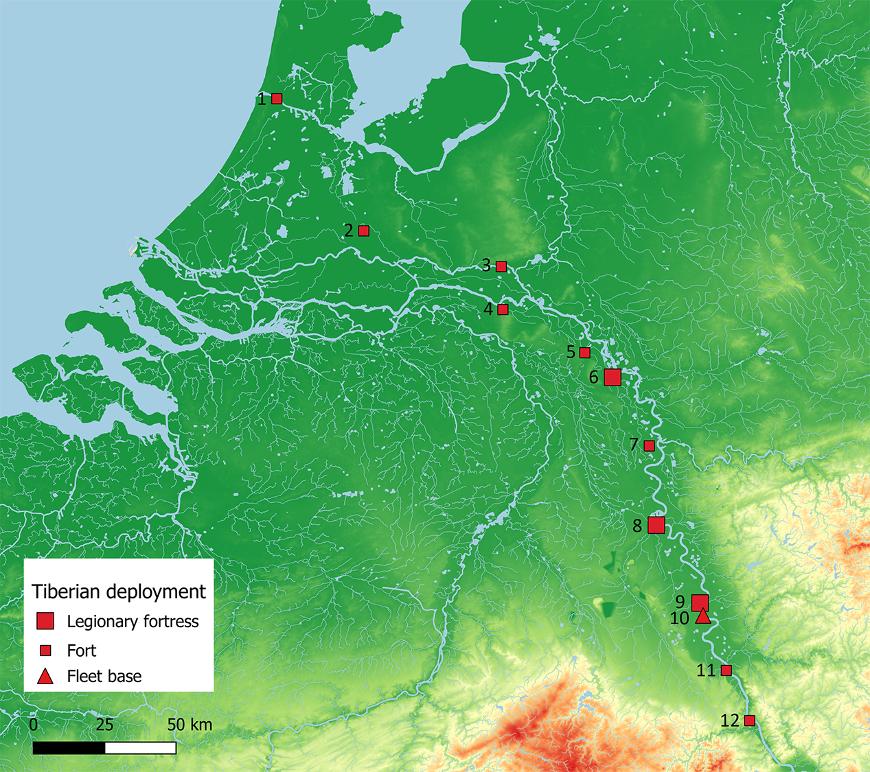
Following Rome’s withdrawal to the left bank of the Rhine, the objectives of the post-Varian campaigns, and indeed the whole German project, were carefully rephrased. According to the same senatus consultum of AD 17, Germanicus’ triumphal arch in Rome was to carry an inscription stating that the Germans had been defeated in war and repelled from Gaul, revenge had been taken for the Varian disaster, and Gaul put to order again.57 In this context, Tiberius presumably (mis)used Augustus’ consilium to motivate the reinstatement of the Rhine, instead of the Elbe, as Rome’s pre-ordained frontier.58 He may for a moment have considered retaining the core area of the Larger-German province, based on the Lippe and Lahn and containing the lead mines of Sauerland and some of Dio’s poleis,59 but it was decided to abandon all positions beyond the Rhine. The bases at Mainz, Neuss, and Xanten were reoccupied, the former and latter housing two legions, while new legionary bases were placed on the Upper Rhine at Strasbourg and Windisch, far away from the recent hotbeds of warfare, presumably with an eye on Gaul.60 The new arrangement clearly was the result of a strategic decision, with the Rhine now again serving as a boundary, barrier and logistic feeder, aspects explored below.
The Tiberian disposition on the Rhine is a fine example of the early Roman policy to place massive strike forces in key positions that controlled the main theatres of potential unrest. It was not coincidental that the two double fortresses, Xanten and Mainz, each stood at the base of the natural penetration axes into Germany, the Lippe valley and the Vortaunus-Wetterau-Giessener Becken route. The Rhine was garrisoned with eight legions, projecting an immense military power far and wide into the Barbaricum. With the Germanic peoples recently reminded of Rome’s military might, and usually divided among themselves, often also internally,61 there was no chance for them to throw the left bank of the Rhine into serious trouble again. Military threats continued to arise in the 1st century, but these were usually dealt with swiftly.62 More importantly, the ‘big stick’ of the Rhine garrison served to back up a policy of indirect dominion via client kings.63 A faction of the Cherusci is reported to have asked Rome for a king in 47, whereupon they received Italicus, a close relative of Varus’ adversary Arminius.64 Later in the 1st century, a king was forced upon the Bructeri.65 Often it sufficed to fuel the proverbial Germanic discordia by selectively providing, or withholding, military or financial support. Rome also made sure that it kept control over the right bank of the Rhine. In 58, Frisian settlers were forcefully evicted from the zone across the river that was reserved for military use.66 At some point, Legio I Minervia, stationed at Bonn, had its prata across the Rhine enlarged and marked out.67 Exercises were held on the right bank by the legions and their associated auxiliary units, witnessed by the practice camps around Geislar and Wesel-Flüren across Bonn and Xanten, respectively. A Tegularia Transrhenana is attested for the pre-Flavian period through many tile stamps. It all helped to support the official position that the province of Germania, which probably had included the civitates on the left bank from the start, had never been abandoned.68
It is tempting to read a purpose-made ‘river frontier’ into the military disposition that we see unfold along the Lower Rhine after 16. Several caveats are in place, however. First, the dense chain of installations of the late 1st century was not a coherent design, but the result of a 70-year incremental development, with installations of various nature and purpose being added in successive steps. In the Tiberian period we are essentially looking at a few main bases, at Xanten, Neuss, and Cologne-Alteburg, where the German fleet was based, with branch establishments and special-purpose sites elsewhere,69 like Bonn-Erste Fährgasse (a logistic hub?) and Nijmegen-Kops Plateau (seat of a praefectus gentis for the Batavi,70 and/or a cavalry training centre?71), and a few outposted cavalry units keeping in check the flanks, like at Kalkar and Bonn-Rathausplatz.72 In the Rhine delta, the Tiberian bases at Arnhem-Meinerswijk, Vechten and Velsen were too widely spaced to exert the level of control associated with the classic limites of the 2nd century. They may have played a role in controlling and supporting the watery motorway to the north and, in the case of Velsen, with governing and taxing the Frisians.73 Feeding the forces of Lower Germany was a logistical challenge. Most of the food supply had to be conveyed from the Gaulish interior—over water, as villa-based surplus production in the Rhineland did not emerge until the later 1st century.74 This factor alone suffices to explain that all the military installations were drawn to the river bank. For the same reason, legionary fortresses elsewhere, with few exceptions, were situated on navigable rivers. Concentrating the military infrastructure on the left bank of the Rhine killed three birds with one stone: the river-based praesidia provided secure harbours, facilities for maintenance and support, and military surveillance of river traffic.
After 16, the Rhineland remained the most strongly held frontier sector of the Roman world for seven decades. The main bases between Mainz and Xanten effectively guarded the gates to the heartlands of the Bructeri, Cherusci, and Chatti. The double fortress at Vetera projected military power far into Germany due to its position opposite the mouth of the Lippe. At the same time, Vetera, due to its terrain setting, was formally oriented to the south.75 In this context it bears quoting Tacitus’ comment on the legionary disposition in 23: “But our chief strength was on the Rhine, as a defence alike against Germans and Gauls”.76 After all, when the post-Varian disposition took shape, it was little more than one generation ago that the future province of Lower Germany had been repopulated with what would in time become the Ubii, Cugerni, and Batavians. If the constitutive Batavian core group was transferred to the Rhine delta in c. 19 BC, as argued above, the synchronous foundation of Nijmegen-Hunnerberg, close to their future capital, is noteworthy. In general, one can observe a broad spatial and chronological correspondence between early military bases and resettled Germanic tribes all along the Rhine.77 It would appear that Rome’s military might was there inter alia to monitor delicate integration processes in recently repopulated borderlands. The attempted Gaulish uprising of Florus and Sacrovir in 21 and the Frisian rebellion in 28 illustrate the point.78
Early communication and corridors
In the quest for signs of early frontier development scholarly attention has obviously focused on roads. Early evidence of road construction, dating to the first two or so decades of the 1st century, has indeed been found in the Xanten-Cologne sector, the core area of Lower Germany. This includes a dendrochronological date of AD 17 for a branch road at the Waidmarkt just outside the south gate of Cologne.79 However, the question is whether the early Rhineland road can be seen as the equivalent of the frontier roads of the classic age of limites, like the Alblimes and Odenwald roads in Upper Germany and the Stanegate in England. More directly comparable, and more closely contemporary, would be the Fosse Way which linked up the early British bases at and between Lincoln and Exeter from c. AD 47. The road cut through several tribal territories and did not necessarily define the edge of Roman control; rather it served as a baseline and springboard for military action at any point in, behind or beyond the broad zone of military occupation.80 The early Rhineland road, likewise, would have allowed for swift ‘horizontal’ troop displacement, enabling the main striking forces to quickly deploy for action at any point along the line, whether it be in the foreland or in the hinterland. But it also served as a backup for the river as the system’s main logistic artery.81
The conditions of river traffic certainly influenced military deployment. In the late Augustan period, the installations at Andernach and Remagen had been placed in ‘bottleneck’ positions, just upstream of a sudden narrowing of the river valley, with ensuing difficulties for river traffic. This curious locational preference is a hallmark of what has been labelled ‘fortified transport corridors’, i.e. river stretches through difficult terrain, usually away from the main forces, where the protection, propulsion, and further support of river traffic posed special challenges, leading to relatively early, and in places dense, chains of installations, often including fortlets and/or towers. Examples are the late Tiberian-early Claudian installations on the Upper Danube and in the Iron Gate gorge in Serbia.82 In this light, the somewhat triangular installation at Moers-Asberg (Asciburgium), and a rather similar early enclosure with associated Augusto-Tiberian finds at Kalkar (Burginatium),83 remind us of the Uferkastelle (riverbank forts) at Haltern and the harbour fort of Velsen 1. Many dots on our Roman military maps, certainly those of the pre-Flavian Rhine and Danube frontiers, may in fact be to do more with supply logistics and the conditions of river traffic, including fleet operations, than with the preclusive, linear security systems of the 2nd-century limites.
Developments in the Rhine delta and beyond
The early 40s saw important changes in the military disposition, especially in the Rhine delta, triggered by Caligula’s planned and Claudius’ successful invasion of Britain. Whether two newly discovered bases of (near-)legionary size, at Valkenburg and Velsen84, are related remains to be seen. The former, with an associated dendrochronological date of 39-40, appears to have been a short-lived if not abortive affair, while the latter saw construction work going on in 42-43, perhaps as a replacement for Valkenburg.85 Velsen was better placed to monitor the administrative integration of the Frisii, a process that was in full swing in the following years.86 One is reminded of the near-contemporary British fortresses, like Exeter, Usk and Wroxeter, all commanding their own regional ‘legionary fronts’.87 Along the Rhine, a broad coincidence is observable in the early Roman period, spatially and chronologically, between major military bases and key areas of recent colonisation and tribal construction.88 In the end, the Frisian project, and the fortress at Velsen, were abandoned by Claudius in 47, for reasons unspecified by Tacitus,89 but likely to do with a wish, or need, to focus on the new British province. The governor Corbulo’s next documented project was the digging of a canal between the mouths of the rivers Rhine and Meuse, “to avoid the dangers of the sea”,90 hinting at Britain-bound provisioning traffic.
Claudius’ instruction to Corbulo to withdraw his forces from Frisia long counted as the birth certificate of the dense chain of forts between Vechten and Valkenburg. However, the dendrochronological dates obtained during major excavations at Alphen aan den Rijn in 2001-2002 now indicate that this fort was built starting with timbers felled in the winter of AD 40-41 and continuing into 42.91 The formation of Alphen’s ‘coin pool’ started with a sharp Caligulan spike,92 a pattern replicated at De Meern,93 while a late Caligulan date had earlier been proposed for the auxiliary fort at Valkenburg.94 Woerden may have been part of this new chain of forts from the start.95 Interestingly, all new foundations conform to what has been styled the ‘delta type’, meaning reduced forts which lack the usual rear (retentura) strip of buildings.96 A recent analysis of the system underlines its unitary design.97 A link with the invasion of Britain in 43, which had been in preparation for three years, to judge the evidence of milestones, seems undeniable.98
Most forts to the west of Vechten were situated across, or next to, the mouth of lesser waterways that exposed the Rhine corridor to waterborne raiding.99 A concern to monitor the river traffic seems to lie behind the positioning of the watchtowers in the well-researched Leidsche Rijn area west of Utrecht. All four sites in question have produced ballista missiles, hinting at their potential to keep the river under artillery fire.100 The Oude Rijn string of forts is a textbook example of the earlier mentioned ‘fortified transport corridors’.101 When discussing the purpose of incremental military investment along rivers outside such corridors, like as happened around the same time in the German Rhineland, with new auxiliary forts placed at Till-Steincheshof and Wesel-Büderich, protection and practical support (harborage, storage, towing, transhipment) of river traffic should always be considered as a possible (co-)motive.
The coming of age of the auxilia and the conversion in stone of the legionary bases
If we are right that the dense chain of forts between Vechten and Valkenburg was much involved in the support and protection of river traffic, there is good reason to suppose that occupation may have fluctuated, at least initially. Provisioning was a seasonal activity, driven in large part by the yearly harvests, notably of grain. Most of the thousands of shiploads of foodstuffs needed to feed the Lower German army in the pre-Flavian period,102 would have been transported within a couple of months. A fluctuating occupation may have been provided by mixed detachments of legionaries and auxiliaries drawn from the main bases in the Rhineland. Such practice was perfectly normal well into the Claudian period. When the Frisians rose in AD 28, they found the fort Flevum (probably Velsen), occupied by a mixed garrison.103 Typically legionary equipment (pila, rectangular shields, artillery missiles) is regularly found in the pre-Flavian forts of the Rhine delta104 as well as those along the Upper Danube. The somewhat fleeting nature of this early occupation may account for the scant evidence of contemporaneous civil settlement and burial activity. At Utrecht and De Meern, the first development of vici and cemeteries is now broadly datable to the Neronian period.105 This is matched by the evidence in Britain where we can see increasing operational and ‘occupational’ autonomy of the auxilia in those years.106
Under Claudius (41-54) a beginning was made with the conversion into stone of the legionary bases on the Rhine, including Windisch, Bonn, and Neuss.107 This process in itself does not mean that the military disposition in Lower Germany was by now considered definitive. Replacement of turf-and-timber structures in stone after a certain time was a normal phenomenon in Roman military construction. There was also a status aspect involved: legionary fortresses usually came first, while in auxiliary forts the headquarters and latera praetorii often had priority.108 In the Rhine delta, the latter process may have started only in the Trajanic period, probably with the HQ buildings.109 As said, building in stone does not in itself indicate that the military disposition was fossilising: Inchtuthil was receiving stone defences at a point in time when the old Flavian policy of total conquest of Britain was still in force, while the defensive perimeter of Hanau-Kesselstadt was built in stone straight away, with the military occupation of the Wetterau only just having begun to unfold. In Lower Germany, likewise, Bonn and Xanten might have supported a future extension of the province to include the old core area of the Larger-German province between Lahn and Lippe, had such a policy been adopted in Rome.
The Domitianic disposition
The Flavian period started with a reminder that the Rhine garrison was there for internal as much as external security issues. The Batavians had risen in 69, bringing havoc and chaos to the whole Lower Rhine region, so they needed to feel (and the surrounding region needed to see) Rome’s iron fist. A legion, X Gemina, was quartered on the Hunnerberg again, close to the old oppidum Batavorum, some 10 km behind what counted as the imperial boundary. New forts were built at Kesteren and Maurik on the Rhine, but also at Rossum on the river Waal, far behind the imperial frontier, but close to Lith-Kessel, one of the Batavians’ major cult centres. The new installations effectively formed a ring of forts around the Batavian civitas. In the final stage of the AD 69 rebellion, the Treveri and Lingones had declared independence, while the loyalty of other Gaulish tribes had wavered. In a reversal of the main trend forward, a legion, VIII Augusta, was planted in the territory of the Lingones shortly after 70. The fortress at Mirebeau-sur-Bèze occupied a turntable position in the main Gaulish road network and was situated close to a cult centre.110 It stayed there until the mid-80s, when the whole deployment in Upper and Lower Germany was reorganised.
Following his Chattan war of c. 83111 (another example of an imperial campaign on the northern frontiers launched in order to gain battlefield credits for a new emperor without a military track record112), Domitian finally turned the military commands of Upper and Lower Germany into formal provinces. The previous arrangement had been unique in the Roman world, a declaration almost that the German agenda was still on the table.113 In Upper Germany, the military presence on the other side of the Rhine had stepwise unfolded, first opposite Mainz at Wiesbaden and Hofheim, next in the Groß-Gerau area, then with the Rhine bridge at Koblenz of AD 49114, and finally, under Vespasian, along various axes, with fort-building in the Neuwieder Becken (Bendorf), in the Vortaunus-Wetterau region, and around Rottweil on the Upper Neckar.115 By the early 80s, with the Armenian issue settled under Nero and Britain now close to complete conquest, the German question was the big remaining issue of Roman ‘foreign policy’. From Pliny the Younger we learn that his uncle had written “twenty books on the German wars, in which he assembled all the wars we have fought with the Germani”—“so long have we been in conquering Germany”, Tacitus would add.116 Karl Strobel has convincingly argued that:
it was Domitian’s (and his advisers’) declared aim from the beginning, in connection with a personally led campaign against the Chatti, to declare the Germanic question, which had been left open as an option since Augustan times [...] to be solved and, through the proclamation of Germania capta, with the associated creation of the Germanic provinces, to lay claim to have concluded a century of Roman Germany policy with a final success.117
Domitian’s German ‘victory’ and settlement were broadly publicised as surpassing the successes of his father and brother,118 and to a certain extent even those of Augustus, as the renaming of the months of September and October to Germanicus and Domitianus implied.119
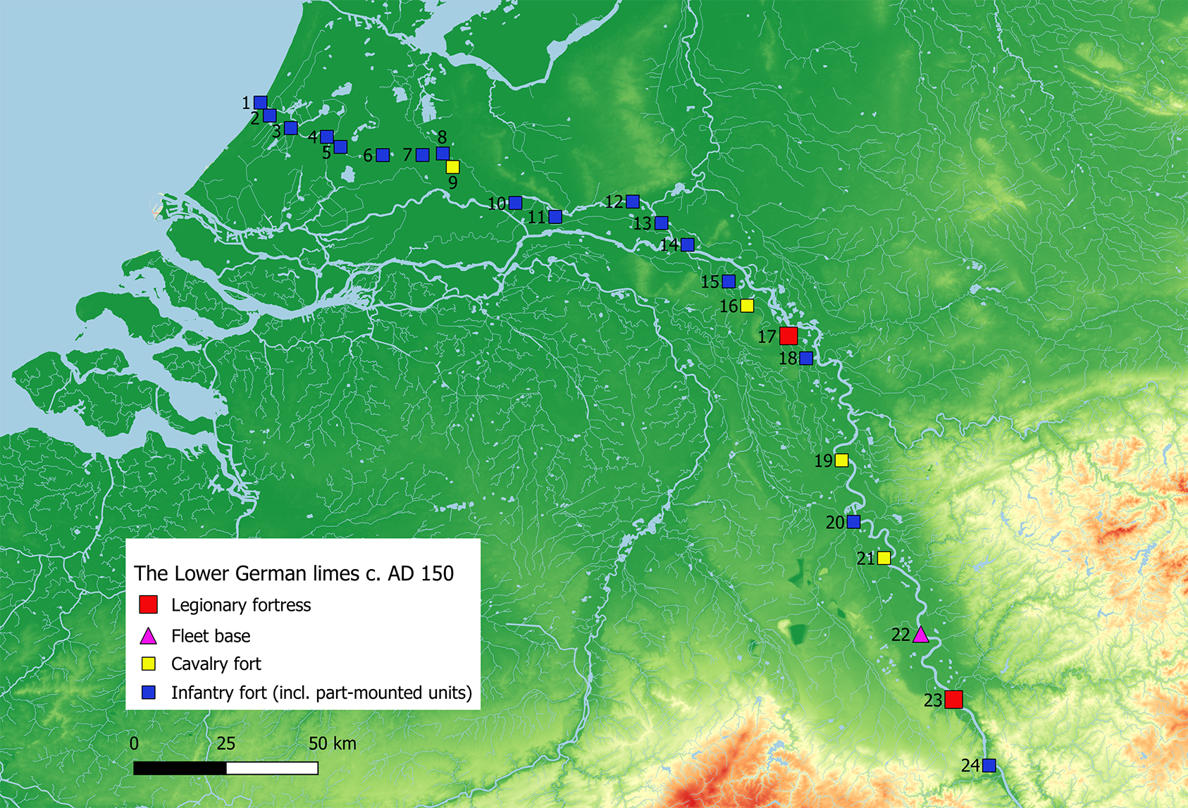
Strobel makes a strong case for 84 as the year in which the two German provinces were instituted, heralded by the Germania capta coin issues which started later in that year.120 In Upper Germany, the new lines of forts and fortlets that unfolded from c. 85/90 largely prefigured the later provincial contour, taking in several pockets of land with good agricultural potential.121 In the Wetterau, the line from Hanau-Salisberg to Heldenbergen, including a running ditch-and-rampart guarded by fortlets, can now be dated to the early Domitianic period, showing the concept of artificial preclusive frontiers to be in development by then.122 In Lower Germany, the existing disposition was basically retained, but not without consideration. The old Augustan installation at Moers-Asberg was abandoned and a new ala fort planted at Dormagen, filling up one of the last remaining gaps in the Rhineland, perhaps suggesting that a spacing norm had by now become de rigueur. Interestingly, the earliest dendrochronological date connected with the limes road in the Rhine delta is 89,123 or perhaps 86/87.124 In the Utrecht area, it appears that the road did not develop out of earlier trackways, but was a new creation, by-passing the two local forts that lay somewhat tucked away in northward river bends, thus forming the shortest possible horizontal baseline for swift movement conceived on a supra-local level.125
The Rhine: frontier barrier, operational axis, logistic lifeline
It has often been stated that rivers are not good as frontiers, their natural role being to connect rather than divide peoples. In the Roman context, we hear that communities on both sides of the Rhine and Danube often had more in common between them than with the centre of the Empire.126 This may all be true, but it is an observed fact that, throughout history, rivers have often been proclaimed as ‘natural’ boundaries by states and empires.127 One of the reasons is that many rivers—and this certainly includes the Rhine and Danube for most of their length—are formidable obstacles for armies and war bands alike, and therefore perform excellently as part of military defence systems. In his military handbook, Vegetius devoted a chapter to the difficulties and dangers of crossing a river with an army column.128 For a raiding band, crossing a 0.5-1 km wide river in substantial numbers required serious preparation, including the collection of vessels. Such a transfer took time and made any party vulnerable. In the case of raiding, the intruders, if sensible, would need to leave behind part of their force in order to guard the vessels.129 There is a good reason why there were no bridges over the rivers Rhine and Danube where these served as the boundary of the Roman Empire.130 When the Upper German-Raetian limes was abandoned in the later 3rd century, the new frontier line was rerouted to follow the rivers Danube, Iller and Rhine,131 in spite of this creating a re-entrant into Roman territory.
Roman military planning authorities appear to have been aware of the security benefits of major rivers like the Rhine and Danube. In general, excluding ‘fortified transport corridors’, distances between forts along those rivers were appreciably longer than on contemporary artificial frontiers. In the Rhineland, the average distance between the fortifications between Remagen and Till-Steincheshof in the 2nd century was about 17 km; on the busy stretch of the ripa Pannonica in Hungary between Budapest and Altinum it was c. 15 km; in Moesia Inferior, between Novae and Carsium, where the Danube in many places was over 1 km wide, the average interval increased to 26 km.132 On Hadrian’s Wall, in contrast, spacing was much closer at 11 km for the primary forts, and 8 km in the final disposition (excluding Vindolanda); on the Vordere Limes between Miltenberg and Lorch it was 13 km; on the exposed the Wetterau-Limes from Großkrotzenburg to the Saalburg a mere 8.5 km. Our picture of watchtowers along river frontiers is admittedly lacunose, partly because there is no artificial barrier to guide us to their remains, partly because their sites are naturally prone to erosion. But the general impression is that river frontiers could do with much fewer towers. In the Rhineland, a well-placed watchtower could easily oversee 3-5 km of the river (their surface is much easier to monitor than land covered with scrubs and vegetation), whereas artificial frontiers had towers every c. 0.5-1 km.
Finally, the Romans were well aware of the value of rivers as logistic axes and operational baselines in campaign conditions.133 Strabo casually mentions “the Danube, on which the Romans used to convey their equipment for war”.134 In the Rhine delta, Drusus constructed “canals with prodigious labour”,135 in anticipation of one of his waterborne campaigns. Before launching his first Dacian war in 101, Trajan had taken two years for improving the towpath and other infrastructure of the Iron Gate, which included a harbour basin at Prahovo (Aquae) and a 3.2 km long canal.136 During the Marcomannic wars, M. Valerius Maximianus was charged with “the conveyance, by way of the Danube, of the goods that were shipped for the supply of Pannonia and both of its armies”.137
It is not just in wartime that the Rhine and Danube functioned as logistic lifelines. We’ve touched upon this aspect earlier, but it is worth specifying what we are talking about. Feeding the army of the Germanies was a serious challenge, certainly in the pre-provincial period, when there were eight legions to cater for and villa-based surplus production of grain had barely started in the immediate hinterland. For Lower Germany alone we’re talking about some 40,000 troops.138 About 2,000 shiploads of grain were needed to feed the pre-Flavian Rhine garrison.139 Over and above that came quantities of wine, oil, fish sauce, beer, and non-food items like timber, stone, leather and metals. Heinrich Konen has pointed out the crucial importance of the Rhine and Danube as supply lines in the 1st century, their tributaries and overseas connections opening up remote areas. The pre-Flavian army in Lower Moesia was supplied by regions as far away as Gaul, northern Italy and Asia Minor.140 At the beginning of the 2nd century, the Cohors I Hispanorum Veterana stationed at Scupi in northern Macedonia had some of its men procuring cloths as far away as Gaul.141 So dependent were pre-Flavian Lower Germany (and Britain) on supplies from the wider Gaulish and Mediterranean hinterlands that plans were made around 58 to construct a canal between the headwaters of the Saône and the Moselle.142 Building materials were another matter. The oak piles for Hadrian’s limes road in the Rhine delta were sourced some 150 km upstream—and conveyed over water.143 Most military stone construction in Lower Germany was carried out in tufa which was quarried in the Brohl valley in the Eifel, just outside the province. It was also thanks to river transport that the brickworks at Nijmegen-Holdeurn could supply the whole Dutch frontier sector with ceramic building materials.
Rome’s first frontier
The foregoing survey of Lower Germany, with occasional forays beyond, lends little support to the view that Roman frontiers gradually fossilised because the imperial system favoured ‘complacency, even apathy’.144 The British experience, in particular, may suggest that Roman advance repeatedly came to a halt on the threshold of military overstretch.145 But more typically the locality of Roman frontiers was the result of imperial decision-making, with campaigns, and intended conquests, often planned two or three years in advance.146 It was the same with the abandonment of territory. This was usually not the result of a gradual crumbling away of the Roman position, but the ordered outcome of central decision-making—vide Germany in 16, Frisia in 47, Scotland c. 86 and c. 105, trans-Danubian Raetia in 254, Dacia around 270, and trans-Rhenish Upper Germany later in the 3rd century.147 It bears underlining that such decisions of advance or retreat were not within the authority of provincial governors, but normally required special imperial mandata.148 We have the Lower German example of Corbulo to illustrate the point.
Lower Germany also exemplifies the magnetic effect of Europe’s main rivers. The scale of the Rhine and Danube, in terms of width, depth, and length, enhanced their riparian utility as the markers of Roman territorial claims, operational axes, logistic lifelines, and security barriers. The Rhine in particular provided a connection, also via the Rhône, Saône and Moselle, between the Mediterranean world and the southern coasts of the North Sea. If Rome was to rule Gaul, control of the Rhine’s left bank was essential. Because of these benefits, especially in the sphere of supply traffic, the Rhine and Danube tended to distort the expected patterns of military deployment, inviting an early jump forward at a point in time where the occupying forces still had much unfinished business at their back. For the interior of the Rhine provinces, we have a dense track record of unrest and uprising occurring at least in 12 BC, AD 9, 21, 28 and 69.
We have seen that the Lower German limes, in its final, late 1st-century state, was the result of a long and complex development. All the named functions of Rome’s frontier rivers are reflected in the installations that successively, and incrementally, landed on the left bank of the Rhine. In the foregoing we have discussed Rome’s early bulwark in the far north, Nijmegen, the winter bases of Drusus’ campaigns, the concentrated striking forces of the Julio-Claudian period, the ‘fortified transport corridor’ between Vechten and Valkenburg of the early 40s, the ring of fortifications around the Batavians of the early 70s, and a few adjustments in the mid-80s. By the time the Rhine provinces were instituted and the first steps towards preclusive artificial frontiers were made in Upper Germany, a dense and continuous chain of installations had come about on the Lower Rhine. Before long, auxiliary forts started to emerge in greater density along the Danube from Noricum to Lower Moesia. In that sense, Lower Germany was home to Rome’s first frontier.
Domitian claimed to have settled the old German problem for good. His equestrian statue in Rome showed his horse trampling a personification of the captive river Rhine, as the epitome of Germany.149 There is certainly some truth in Domitian’s claim. With the military disposition as it solidified from the mid-80s onwards, Rome for several generations achieved effective control of trans-Rhenine Germany without occupation. There was no reason for further forward action. And there was a powerful factor that kept things as they were: the river Rhine—connector and barrier at the same time. There are good reasons why the rivers Rhine, Danube, Euphrates, Jordan (until 106) and Elbe (under Augustus) were proclaimed, and maintained, as the boundaries of Roman-controlled territory.150 Tacitus called Rome’s frontier rivers “the old defences of the Empire”.151 Perhaps more importantly, they were the lifelines of supply. David Breeze has plausibly suggested that the Rhine and Danube “became too convenient to abandon especially for a people so wedded to bureaucracy and so organised when it came to supplying their troops as the Romans were”.152
Between c. 250 and 300, Rome stepwise abandoned the territories it had held beyond the Rhine and Danube for one and a half centuries or more. Somewhere in that same period, most forts in the Rhine delta were vacated (with scant evidence for structural occupation in the following century), and the sandy soils of the Maas-Demer-Scheldt area in the southern Netherlands and northern Belgium depopulated, in a forced manner, it would appear, as part of a reorganisation of the Lower German frontier.153 But the old military bulwark on the Rhine, between Bonn and Nijmegen, was largely kept in place, replicating the pattern of the early Roman period. While Roman governors continued to reside in Cologne until 456, gold payments to Frankish war-band leaders, both inside and outside the old province, went on for a few more years,154 keeping up the 500-year-old claim that Rome ruled the Rhine.