
Introduction
The River Rhine demarcated the border of the Later Roman Empire in continental north-western Europe.1 It had done so, at least on the Lower Rhine, already in the High Empire.2 Along the course of the river many military installations of varied types existed on both banks. Fortifications were also erected in the hinterland, especially along the arterial roads leading into inner Gaul. Roman activities—not only military operations, but also measures of a diplomatic, political, and economic nature3—extended into and influenced the territories outside the Empire. It is therefore not only a border, but a ‘frontier’ of the Empire, a zone and ‘distinct landscape’.4 This is reflected by the use of the term limes in the written sources. Whereas limes is generally used by modern scholars for the demarcated border of the High Empire, as in ‘Lower German limes’ and ‘Upper German-Raetian limes’, in the written sources from the 4th century onwards it described a zone: a designated frontier district under the command of a dux.5 The Rhine frontier remained more or less stable until the end of the Western Roman Empire,6 even if it did undergo adjustments and transformations and even “brief periods of collapse”.7
This paper sets out to present a summary of the state of archaeological research on the late Roman Rhine frontier (Fig. 1): the military installations on the Rhine, fortifications and settlement development in the hinterland and in the barbarian regions immediately outside the Empire.8 The timespan considered starts at the beginning of the 4th century and reaches up to the middle of the 5th century, when in the Rhine region and northern Gaul the transition to the early Middle Ages was well on its way. An issue for archaeological research in this specific field is the large-scale erosion caused by the meandering of the Rhine in its floodplains in post-Roman centuries. Sites were completely destroyed by the force of the river. This led to an almost total loss of data for whole sections of the floodplain.9 Finds from these lost sites were displaced vertically by the meander erosion, but not transported downstream. They are now embedded in the gravel several metres below surface level and are sometimes dredged up during gravel extraction.10 They can provide a glimpse of what was lost, but rarely more. Any reconstruction of military defence systems or settlement patterns is therefore difficult.
Figure 1: Late Antique Fortifications along the Rhine from Lake Constance to Nijmegen. Note that the Hochrhein-Limes with its many small fortifications is not fully mapped (see Hächler et alii 2020).
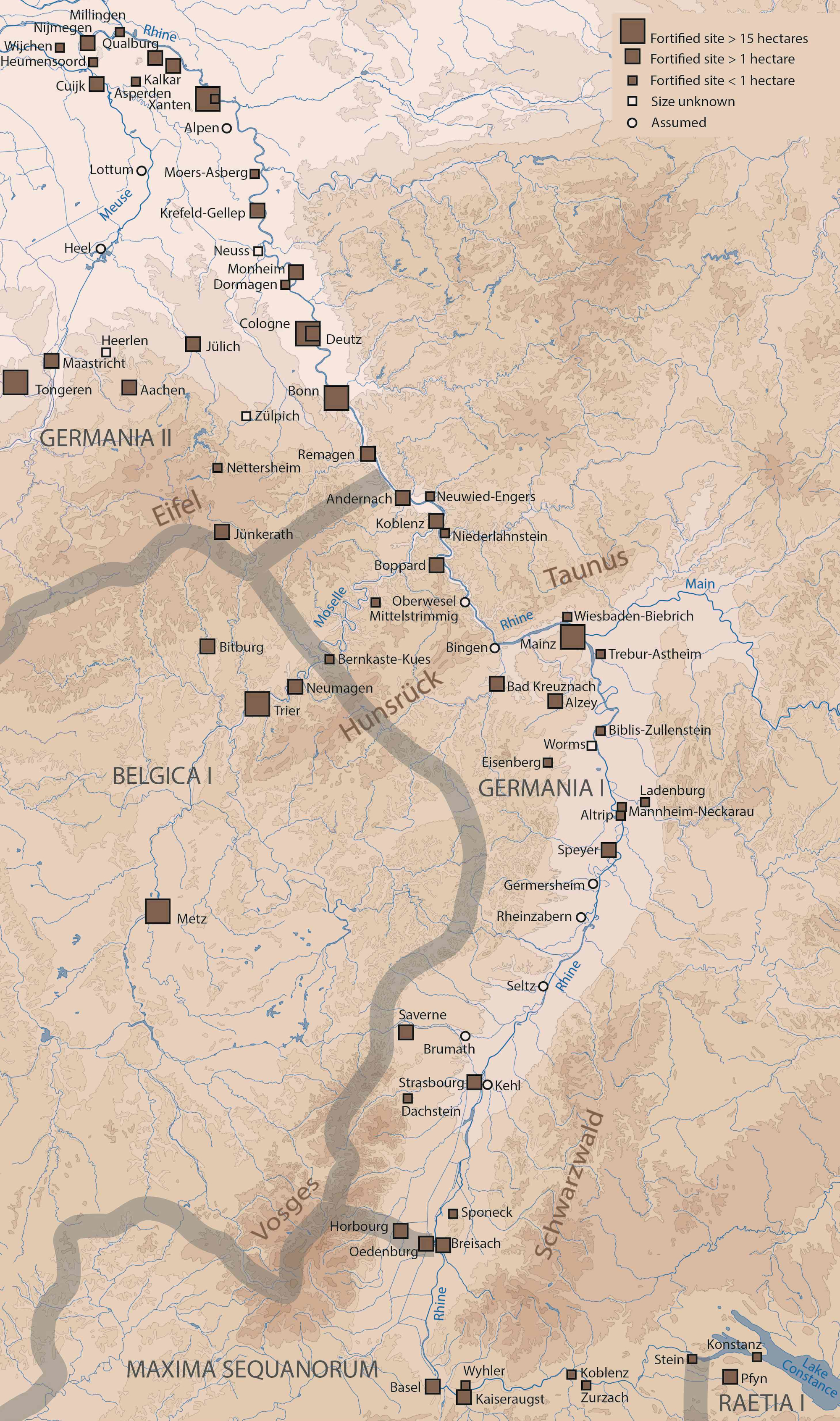
Credits/sources: Marion Brüggler with data from BoDeOn (LVR-database), Brulet 2017, Heimerl 2021 and Hächler et alii 2020. Basic map Christoph Duntze, LVR-LandesMuseum Bonn.
What and where was the Rhine?
With its length of more than 1,200 km from the Alps to the North Sea the river flows through four provinces from south to north: Raetia I, Maxima Sequanorum, Germania I, and Germania II. The Rhine passes through many distinct landscapes and thus posed different challenges for military use. After leaving the Alpine regions of its source in the Swiss Alps the river crosses Lake Constance. It continues its westward course, the ‘Hochrhein’ (High Rhine), and turns north at Basel. It then flows through the broad floodplain of the Upper Rhine Valley. Shortly beyond Mainz the river enters the low mountain ranges of the Middle Rhine. At Bonn it enters the Lower Rhine Plain and just beyond the modern German-Dutch border east of Nijmegen it bifurcates into Waal and Nederrijn and enters the Rhine Delta.11
While the river was stable in its bed in the mountainous sections, in the floodplains of the Upper Rhine Valley and the Lower Rhine Plain it changed its course especially before and after the Roman era (Fig. 2). Here the river had a very different character than it does today, after being fixed in its bed by the severe river regulations of modern times. The Roman Rhine was not a single broad, meandering river, but rather had a main channel, side channels, and oxbow lakes as well as islands. All in all, it was wider, considerably shallower, and more braided.12
These widely different topographical conditions affected the defence of the border in different ways. The navigability of the watercourse is important for patrolling or crossing the river. A problem for both actions was not so much high currents but rather too little water.13 Low water levels hindered waterborne traffic and allowed attacks across the Rhine into the Empire—they also allowed forward-defensive actions by the Roman army into enemy territory, for that matter. The topography of the riverbanks dictated the location of forts and fortlets. The terrain also affected the visibility of the forefield; it was restricted in the mountainous areas, whereas in the floodplains side channels and alluvial woods posed a challenge to visibility and the options for defence.
Figure 2: The Lower Rhine downstream of Krefeld-Gellep, with sites of the Lower German limes.
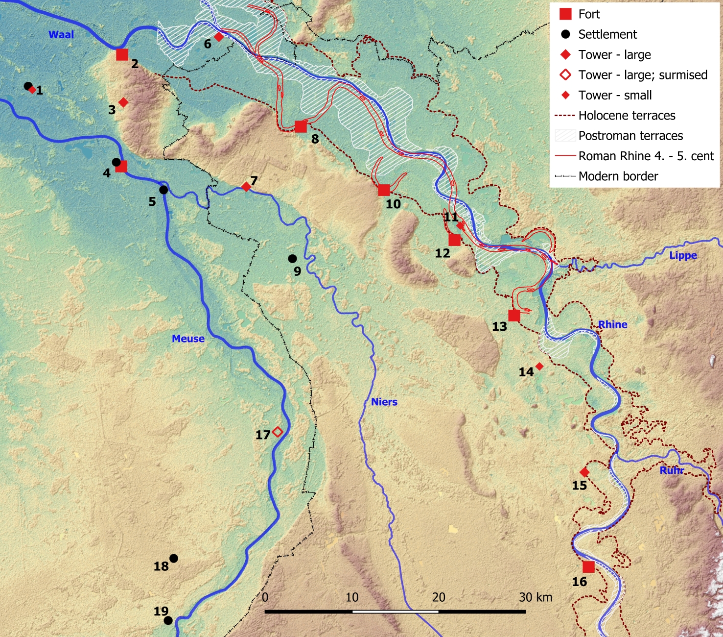
1 Wijchen, 2 Nijmegen-Valkhof, 3 Malden-Heumensoord, 4 Cuijk, 5 Gennep, 6 Millingen, 7 Goch-Asperden, 8 Qualburg, 9 Weeze-Knappheide, 10 Kalkar, 11 Xanten-Lüttingen, 12 Xanten, 13 Alpen-Drüpt, 14 Rheinberg, 15 Moers, 16 Krefeld-Gellep, 17 Lottum, 18 Helden-Schrames, 19 Neer-Wijnaerden.
Credits/sources: Johannes Tieke, LVR-Amt für Bodendenkmalpflege im Rheinland (LVR-ABR). Holocene floodplain terraces, GIS: Irmela Herzog, Reiner Lubberich, and Renate Gerlach LVR-ABR, Grid: SRTM (executed at 30 × 30 m grid).
Within the project “Harbours from the Roman Period to the Middle Ages”, that was financed by the German Research Foundation (DFG) between 2012 and 2018, the subproject “The Rhine as a European transportation route” took harbour sites on the Roman Rhine into view. To this end, in some sections where it had not been previously clarified, the Roman riverbed itself first had to be located. This happened parallel to the Dutch-German initiative from 2005 to 2021 to apply for the Lower German limes to be inscribed as UNESCO World Heritage.14 For a better understanding of the fluvial landscape that was the Lower German limes, the natural conditions were analysed. Combined data from excavations, bore holes, pollen analysis, and electrical resistivity tomography (ERT) profiles and calculations of former water levels greatly increased our understanding of the Roman river.15 In some cases, the Roman riverbed was located for the first time, proving that Roman military sites were actually situated on the undercut bank of the main channel. It had previously been thought that they were built on side channels or even oxbow lakes to avoid danger of erosion.16
As a major river the Rhine was affected by climatic developments, which in turn also had effects on the defence of the border. From the 3rd century onwards, the climate became less stable than in the three centuries before. At the beginning of the 4th century a warming set in.17 The Rhine maintained its run-off deficit, implying that rainfall had not increased significantly.18 From the second half of the 4th century, wet summers were more frequent in the north-western provinces. From AD 400 indicators point to a wetter and colder climate.19 Reports of freezing increased already over the 4th century, with incidents in AD 304, 356, 363, 367, and 378.20 A frozen river provides easy crossing, and it was even possible to ride across on horseback.21 In the opposite case of more extreme warm weather, barbarians used low water levels to cross the Rhine.22 That is to say that in both colder and wetter conditions as well as warmer drier conditions, the Rhine was a less effective barrier to movement from one bank to the opposite side.
At some point in the late Roman era or in the Early Middle Ages, the Rhine began to meander again more strongly than it had in the High Empire. It had previously been argued that the cause for this increasing meandering activity was the mentioned climatic change with its higher rainfall. However, another factor may have played a more crucial role: Bank protection measures and other hydraulic engineering activities, which were maintained in the High Empire and held the river in its bed, were neglected during or after the late Roman era.23 As yet, there is no proof of hydraulic engineering activities for the Lower Rhine in this period. The Roman army was definitely organisationally and technically able to conduct large-scale hydraulic operations.24 Ammianus reports for AD 369 that the Neckar posed a threat to a fort at the confluence of the Neckar and the Upper Rhine, and that hydraulic engineering measures had to be taken to redirect the course of the Neckar to protect the fort.25
Military Installations along the Rhine
Whereas the Lower Rhine formed the border already before the turbulent second half of the 3rd century, the line of the Upper German-Raetian limes was given up and a new border created, the Rhine-Iller-Danube limes.26 This meant that the whole military infrastructure on this new line had to be built anew, apart from the legionary fortresses of Strasbourg and Mainz that had previously lain in the hinterland of the Upper German-Raetian limes; this shift meant that Strasbourg and Mainz were now more closely located to the military frontlines.27
The reorganisation of the Roman army under Diocletian and Constantine I had an obvious impact on military fortifications. A mobile field army, the comitatenses, was stationed in the interior of the provinces, while the ripenses, later limitanei, were stationed along the borders to take care of road security and control movement across the border. They were expected to manage local defence and stood under the command of a dux limitis.28 Apart from this differentiation of unit types, the units were also greatly reduced in size: a legion now probably only consisted of 1,000 men.29 Accordingly, Late Antique fortifications differ from those of the High Empire.30 There was a range of different types of military installations: large fortresses, forts, fortified towns, fortlets, and watchtowers (burgi, turres), hilltop-forts and fortified landing sites for ships.31 The layouts of the fortresses of the High Empire with their long enclosing walls were given up. Late Antique defensive structures now laid emphasis on strong fortifications and were smaller in size. However, the enclosing walls of the legionary fortresses of Strasbourg, Mainz, and Bonn were strengthened by setting up a new wall immediately in front of the older one, without a reduction in size.32 Due to the complete destruction of the legionary fortress at Xanten, Vetera II, by a medieval meander of the Rhine, nothing is known for this site. Vetera II may have been given up as a legionary fortress altogether and the legion transferred to a new fort within the perimeter of the Colonia Ulpia Traiana nearby.33 Also, in some auxiliary forts of the High Empire the perimeter walls were strengthened, as is the case in Remagen and Kalkar-Burginatium.34
Military installations existed not only along the Rhine, but reached far into the interior of Gaul along a network of roads. Large and small fortified towns, hilltop fortifications, and protected farms now also contributed to the defence of the frontier.35 This network of defensive structures that was not only organised along a defended line but reached into the hinterland has previously been interpreted as “Defence in Depth Grand Strategy”.36 Today, the term “Defence of the Interior” is favoured as there was no “Grand Strategy” over the course of the late Roman era. Different strategies coexisted and were sometimes in operation at the same time: maintaining border defence, using mobile troops to defend the interior provinces, attacking the enemy in their own territories. Measures were taken according to different initiatives and did not coexist, which they would have to if they were part of a grand strategy.37
In the course of the 4th century all Roman rulers engaged in frontier defence. Under Constantine I (AD 306-337) a stone bridge across the Rhine at Cologne and a fortress on its eastern end were built (Fig. 3). The building of the bridge was begun in AD 307-309 and completed in AD 315.38 The erection of a castellum of this size—it could accommodate 1,000 men—and a stone bridge as well as the personal visit of Emperor Constantine underline the strategic importance of Cologne and its bridgehead for the defence of the Rhine.39 Likewise, the fort Monheim-Haus Bürgel was of Constantinian date, probably also the fortress within the perimeter of the Colonia Ulpia Traiana (Xanten) and the Valkhof fortification in Nijmegen.40 The older fortresses of Mainz and Strasbourg and the fort in Remagen were strengthened and secondary towns like Zülpich and Aachen were surrounded by walls.41 At Koblenz, at the confluence of Rhine and Moselle the pre-existing vicus was fortified with strong walls. It secured the confluence and, together with the forts of Boppard, Remagen, and Andernach, the course of the Middle Rhine.42 On the Hochrhein a strong fortress of 3.5 hectares in size was erected at Kaiseraugst, the castrum Rauracense, with a bridgehead on the opposite bank across from the fortress; several other fortifications in this section of the Rhine were reinforced during the Tetrarchy or Constantine’s reign.43
Figure 3: Layout of the Constantinian fortification Divitia in Cologne-Deutz on the modern street map.
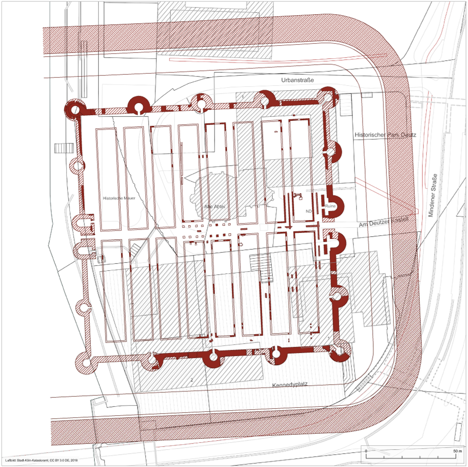
Credits/sources: Stadt Köln/graphic design U. Hermanns Ausstellung Medien Transfer GmbH. Courtesy of Alfred Schäfer, Römisch-Germanisches Museum Köln, after (Schäfer 2021) fig. 1.
Under Constantine’s sons (AD 337-360) a wooden fortification was erected at Goch-Asperden in Germania II, at the same time as the Meuse bridge at Cuijk only a few kilometres to its west.44 Repairs of the Rhine bridge at Cologne seem to have been made.45 Further towns were surrounded by strong walls, maybe in a planned building programme in the 330s and 340s.46
Written sources indicate that Julian played an important role for the Rhine frontier. After being made Caesar in AD 355, he took actions to regain and stabilise the Germanic provinces after the usurpation of Magnentius. Cologne had been besieged and taken by Franks in AD 355, around 45 towns and smaller settlements along the Rhine and in Gaul had been destroyed.47 Julian reconquered these, repaired at least three forts on the Meuse, and secured the grain supply from Britannia.48 Archaeologically, however, it is hard to determine his achievements in strengthening the fortifications along the Rhine.49
Preeminent for securing the Rhine was Valentinian I (AD 364-375). According to Ammianus, he built large forts and towers from Raetia to the Channel coast,50 his account is supported by archaeological evidence.51 In Germania II the bridges across the Rhine at Cologne and the Meuse at Cuijk were repaired, the castellum there as well as the burgus of Asperden rebuilt in stone; the burgus at Moers, very similar to that at Asperden, was erected.52 In Dormagen a burgus was built in the second half of the 4th century in a corner of the older auxiliary fort.53 In Germania I the forts at Alzey, Bad Kreuznach, and Altrip as well as numerous burgi and a row of landing-burgi were erected.54 According to dendrochronological dates, the bridge across the Main at Ginsheim-Gustavsburg near the confluence of the Rhine and the Main was built in AD 374.55 Also, in Maxima Sequanorum the border on the Hochrhein was strengthened with the important fortifications at Biesheim-Oedenburg, Breisach, and Sponeck in the Kaiserstuhl region.56 For the bridge at Zurzach, dendrochronology dates its building to AD 368 and repair works to AD 376. Apart from the stone bridges, pontoon or ship bridges were laid across the Rhine whenever necessary, but these did not find their way into the archaeological record.57 All in all, Valentinian’s measures are considered fruitful, as rural and suburban settlements in northern Switzerland or the construction of a prestigious memorial building outside the perimeter of the city walls in Cologne at St. Gereon show.58
Building and repair works during the reigns of Valentinian’s successors are documented more rarely: Around AD 393 ±5 the Meuse-bridge at Cuijk was repaired, in the last quarter of the 4th century the Rhine-bridge at Cologne.59 A building inscription in Cologne commemorates the rebuilding of an unknown, dilapidated building—probably the praetorium—under magister militum Arbogast in AD 392-394.60 Maybe in the 380s two towers were added to the fort at Krefeld-Gellep (Fig. 4).61 Also on the Middle Rhine building activities are documented for the 390s, namely the bridge at Ginsheim-Gustavsburg.62
Figure 4: Castellum at Krefeld-Gellep at the end of the 4th century.
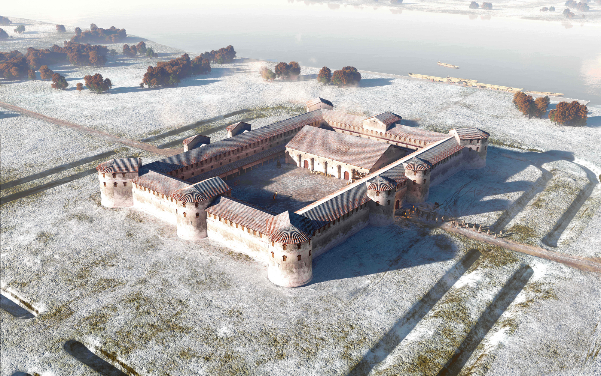
Credits/sources: Mikko Kriek for LVR-Archäologischer Park Xanten (LVR-APX). Courtesy of Christoph Eger, LVR-APX, after (Eger and Ristow 2021) fig. 2.
The fleet
Being a fluvial border, ships must have played a crucial role in the defence of the Rhine. The written evidence, however, is sparse. Constantine I is lauded for furnishing the whole length of the Rhine with soldiers and fleets.63 When Constantius II ordered the building of a ship-bridge at Kaiseraugst, vessels must have been available, whereas Julian in AD 359 had only 40 ships at his disposal.64 The Notitia dignitatum, a text apparently edited from administrative records, most probably in the 420s or the 430s for the western part of the Empire,65 lists the fleet of Lake Constance. This was commanded by the dux Raetiae and probably covered the waterways from the mouth of the river Aare to Bregenz.66 Under Stilicho, ships of the Rhine fleet were ordered to North Africa.67 More generally, it is thought that the conditions on the Rhine can be compared to those on the Danube, which is far better documented.68
The ships themselves have left few archaeological traces. In Mainz five ships and fragments of a dugout boat have been excavated,69 but a fleet bases are not easily identified. The former station of the classis germanica at Cologne-Alteburg had been given up in the late 3rd century, though it is argued that Cologne will have served as fleet base during the 4th century.70 On the Heumarkt in Cologne, a 120 m long building could have served the Rhine fleet.71 Mainz and Strasbourg may have served as fleet bases on the Upper Rhine—of course, any kind of fortification along the river will have been used for the stationing of ships and their crews.72
On the Upper Rhine a certain type of fortification is associated with the operation of the fleet. It is a combination of a fortlet and a secured landing site that was built on the mouths of tributary rivers from east of the Rhine at tactically favourable locations (“Schiffslände-Burgus” or “Lände-Burgus” i.e. landing burgus).73 These fortlets are thought to have been stations for ship patrols and at the same time for surveying the eastern shore of the Rhine.74 They were probably linked by a road on the eastern side of the Rhine, as the bridge across the Main near its mouth at Ginsheim-Gustavsburg points to.75 Interestingly, this type of fortification was only built within the district of the dux Moguntiacensis.76 This, among other things, also speaks against a “Grand Strategy”. Recently, Roland Prien questioned the ascription of several of the sites as landing places: Installations for landing the ships are lacking. Often the waterfront of the forts is not preserved, so the wing-walls that are assumed to extend into the river have not been verified. In some cases extremely steep slopes forbid the landing of ships altogether. Also, an open waterfront with only wing-walls, as is supposedly typical for this kind of fortification, is problematic for the defence of these structures. Ronald Bockius, however, retains the older hypothesis of these sites as fleet stations and watchtowers, and underlines their tactical importance.77 It is a question not yet resolved.
Behind and in front of the border
As stated in the introduction the late Roman frontier along the Rhine was a broad zone that reached far into the hinterland and also affected the regions outside the Empire bordering the Rhine to its east and north. The past two decades have seen several regional studies of rural settlement patterns, which show similarities in settlement developments but also regional differences.78
The linear defence of the High Empire was remodelled into a more mobile and adaptable defence. This is also mirrored in the troops that were now divided into mobile forces, the comitatenses, and border troops, the limitanei (see above). Military installations were now not only erected along the border but also along the major roads that connected the Rhine to the interior of Gaul, which were needed to secure the march routes and supply lines of the army.79
Towns
Along the major roads, secondary agglomerations of the High Empire that lie in between the larger towns were fortified with town walls.80 Along the arterial road from Cologne to Bavay the towns of Jülich, Heerlen, Maastricht, and Tongeren received strong walls, as well as Aachen a bit to the south of that road.81 On the major road from Cologne to Lyon numerous fortified towns can be named: Zülpich, Jünkerath, Bitburg, Trier, Metz or Toul.82 It is a matter of debate whether the building of these fortifications was instigated by the central government or the towns themselves. In view of the similarities in style and dimensions of the buildings, Ferdinand Heimerl argues for an organised programme by the military.83 It is also not clear whether the fortified towns were defended by a local militia or regular military units. Another question is to what extent civilians and military personnel dwelt together within the strong walls, as barracks are rarely recognised.84
These developments apply to towns in the southern part of Germania II and further south. In northern Germania II the situation is different.85 Here, in the late 3rd century a serious urban decline set in. The civitas centres at Voorburg and Nijmegen-Waterkwartier were abandoned. At Nijmegen, a fortification was built at the Valkhof, and at Xanten a castellum was built within the former town.86 The name Tricensima probably applied to this castellum, referring to the 30th legion. This legion had been stationed in the Vetera II fortress in a few kilometres distance during the 2nd and 3rd centuries. This also points to a loss of function of the former colony as urban centre.87
Hilltop settlements
In the Rhine provinces hilltop settlements are known from the mountain ranges of the Eifel, the Hunsrück, the Palatinate, and the Vosges. This phenomenon starts in the second half of the 3rd century. This starting date is often derived from uncontextualised coins of the Gallic Empire (AD 260-274). However, these were used well into the 4th century, with implications for the dating of the hilltop sites.88 The function of these sites is controversially debated. Even though over a hundred sites have been identified, archaeological investigations are very limited.89 Often, a site is only identified due to the remains of the fortifications that are still more or less visible in the landscape and from surface finds. Because of stray finds of military fittings, they are interpreted as connected to the military,90 especially those in the Moselle valley that are seen as part of a Tetrarchic defensive network for Trier.91 However, many of the hilltop sites are not located along roads or waterways, making surveillance and protection of marching routes and supply lines difficult. The fortifications are also rather simple, therefore the interpretation as refuges for a rural population prevails.92
Rural settlements in the Roman provinces
The development of rural settlement in the hinterland varies greatly for the different regions bordering the Rhine.
In northern Germania II, together with the above-mentioned urban decline, a large-scale abandonment of rural settlements by the end of the 3rd century can be perceived. The rural areas seem to be completely devoid of agrarian settlements.93 Stijn Heeren suggested a forced deportation of the population into the interior of Gaul by the Roman authorities.94 Several civitates were dispensed with as tax-paying administrative units.95 By the end of the 4th century, new settlers appear that obviously came from beyond the Rhine, outside of the Empire.96 The abandonment (forced or not) and resettlement of the area does not, however, imply that the territory was no longer seen as being part of the Roman Empire, as the ongoing activities at the military sites along the Rhine document.97
Conditions are different in southern Germania II: On the more fertile soils of the loess zone agrarian production continued, while on the less fertile lands woodlands developed.98 In the early 4th century, glassmakers settled on the sites of former villae rusticae and established workshops, using the new woodlands for fuelling their furnaces. Farming in other villae rusticae continued, but not unchanged. Several villae are now protected by fortifications.99 These protected farms are not restricted to the loess area near Cologne. They are known in northern and eastern Gallia Belgica and Germania II, but are totally absent in Gallia Lugdunensis and Germania I.100 Often the defences are difficult to date, but it is thought that they were erected during the Gallic Empire or shortly after, and used until around AD 370.101 Since they are often documented at villae rusticae that did not lie in the vicinity of major roads and their layouts are very varied, they are most likely not part of a centralised defensive building programme, but are rather private fortifications to fend off marauders.102
In the vicinity of Trier most villae were still used until the middle of the 4th century. After that there is a marked decline but no abrupt end. A few villae even continued into the Merovingian era.103 In the western Eifel marginal lands were abandoned between the end of the 3rd century and the 360s. Here as well, there is no abrupt end after the beginning or even the middle of the 5th century, but rather a thinning out.104
On the Upper Rhine, in the civitates Vangionum and Nemetum some farmsteads were abandoned after the middle of the 4th century but broadly speaking the settlement system stayed intact until around the middle of the 5th century and even later. It is, however, not clear from the archaeological record who dwelled there—a continued population or new settlers.105 Similar developments can be discerned in Maxima Sequanorum, even though beech pollen increases from the early 4th century onwards, indicating a decline in agrarian production in the hinterland of Augusta Raurica; the villa landscape as such seems to have persisted.106
Settlements on the eastern/northern banks of the Rhine
The zone immediately outside the Empire will have felt the influence of the nearby border. Distribution maps of archaeological objects sometimes give the impression of material culture being rather similar on both sides of the river and in fact over large areas extending from northern France, Belgium, the Netherlands, and north-western Germany.107 The conclusion that all of this area hosted a common frontier society both within and outside of the Empire is, however, not appropriate. Michael Schmauder correctly points out that conditions on the left banks of the Rhine with urbanisation, infrastructural achievements, and a general lifestyle influenced by the Mediterranean greatly differ from those in the barbarian regions on the right (east) banks of the Rhine.108 What these distribution patterns do show is that people had access to Roman goods. They show a permeability of the border.109
On the Lower Rhine, a recent study on Roman finds from the eastern bank of the Rhine has proven that in the late Roman period settlements focused more on fertile soils than in the High Empire. This development is in line with settlement developments within the Empire, as stated above. Clive Bridger connects this with a climatic deterioration that forced people to farm only the productive lands.110 Focusing on the more fertile soils is also a sign of a reduced population density in these areas. Those people that had tilled the marginal soils before are gone. They could have migrated to other regions.
In the northern Upper Rhine region, the territories to the east of the Rhine had been part of the Empire until the Upper German-Raetian limes was given up.111 Settlements along the southern Upper Rhine were occupied until about AD 280, after that there is an interruption.112 Marcus Zagermann and Lars Blöck support the idea of a state directive and suggest that Breisach was founded as a new settlement to accommodate the inhabitants of vici and villae in the area.113 After the middle of the 4th century, the southern parts of the Upper Rhine were probably uninhabited. They were afterwards resettled by new settlers and a new hierarchy developed with hilltop settlements as centres.114 Besides these, agrarian settlements existed.115 On the Ostalb, the new settlers arrived already in Tetrarchic times. Their material culture suggests an origin from the Elbe.116 Colluvia covering sites from the time of the High Empire points to an open landscape in this period, and therefore an agrarian use.117
As a general trend, rural settlements on either side of the Rhine, i.e. within the Roman Empire as well as the adjacent barbarian territories, show a reduction in density and a concentration on more fertile soils over the course of the 4th and 5th century. The rural areas of the Lower Rhine, however, seem to be completely devoid of habitation. New settlers arrive—in different regions at different stages—whose material culture points to a migration from areas outside of the Empire, further evidenced by strontium isotope analyses.118 The scale of these migrations has yet to be determined. So far, it is thought of as a trickling-in of small groups, but written sources describe the large-scale land-taking by Franks and Burgundians in the first decades of the 5th century.119 Strontium isotope analyses of human bone or geochemical and petrographical analyses of handmade pottery120 can reveal the geographical origin of migrants and may yield more insight into the future.
Why sustain the Rhine as a frontier?
Loss of territory was problematic for the Empire, because it meant a decrease in taxes, which paid for the army.121 Loss of agricultural land endangered the provisioning of the army and civilians, and made grain imports from other provinces necessary.122 Therefore, agrarian land was not abandoned lightly.123 Both civilian centres and the rural hinterland in northern Germania II were apparently uninhabited from the late 3rd century onwards and no longer yielded tax returns. In fact, there are so far no known military sites between the Channel coast and Nijmegen that were still in use apart from the fortifications of the litus saxonicum.124 Upstream from Nijmegen, however, along the Lower Rhine, military installations were still occupied. Stijn Heeren rightly asks what these fortifications were for.125
Two purposes can be given: trade and defence. The Rhine was an important transport route, connecting not only the settlements along its course, but also linking the north-western provinces to the Mediterranean through the rivers of Gaul, especially the Rhône-Sâone-Moselle corridor, as well as the Alpine passes.126 Finds in the frontier zone originating from as far as the Eastern Mediterranean show an intact long-distance trading network up to at least AD 400.127 Trade along the river itself also continued. Up until the middle of the 5th century, late Roman finewares can be found in most of the fortifications.128 The link to Britain is of course also important. Southern Britain in the 4th century is very prosperous, and during the mid-4th century it became the “granary” of northern Gaul as shown by a passage in Ammianus, in which Julian built new granaries in cities along the Rhine, in order to store grain imported from Britain.129 The connection between the Rhineland and the south-east of Britain in Julian’s efforts for supplying the army with grain is supported by a higher proportion of coinage from the years AD 348-364 that was minted in Trier and found in British ports. After AD 364 the numismatic evidence no longer supports a close connection between south-east Britain and the Rhineland. The mints at Lyon and later Arles became the main suppliers of coin, and the Rhine decreased in importance connecting Britain to Central and Southern Europe.130
The main reason for the upkeep of the Rhine frontier, however, was as a security buffer for habitation in central Gaul, the safeguarding of which was a central aim of the Empire.131 If the limes on the Lower Rhine downstream of Cologne was given up, a new border would have to be established. There is no other natural border in northern Gaul that was as suitable as the Rhine. The arterial road from Cologne to Bavay and further west is hardly suitable as a new border, even if it has been labelled Limes Belgicus.132 With the same justification, one could call the arterial road from Cologne to Lyon a limes.133 The problem here is the gap in defensive structures between Nijmegen and Katwijk and the coastal defences of the Litus Saxonicum, noted above. Either these have yet to be found,134 or the defence was organised in other ways. The settlement of barbarians as foederati to fend off enemies in return for land is one possibility. In fact, Raymond Brulet localises “Toxandria” in this gap, where Caesar Julian is reported to have settled foederati.135
The definitive end of the Rhine frontier?
Rome’s activities on the Rhine frontier are well documented through archaeological research and written sources up to the time of Emperor Valentinian I. It is harder to identify building activities in military installations after Valentinian. The latest proven construction works on the Lower Rhine date to the last decade of the 4th century at Cologne and Cuijk.136
In AD 401 Stilicho withdrew troops from the Rhine and ordered ships of the Rhine-fleet to North Africa.137 On New Year’s Eve of AD 406 Germanic groups crossed the Rhine and advanced deep into Gaul. This incursion took place on several sections of the Rhine, the northernmost probably near Koblenz. The Lower Rhine does not seem to have been affected by it. Until AD 411, military support for the Lower Rhine came from Britain with the usurper Constantine III (AD 407-411). This ceased with the defeat of Constantine III by Emperor Honorius’ forces, and the permanent loss of Britain for the Empire. The frontier on the Lower Rhine then became part of the usurper Iovinus’ (AD 411-413) dominion until 413, when he was executed.138
More than a decade later, magister militum Flavius Aëtius was engaged with securing Gaul and the Rhine. In his campaign against rebellious Franks from AD 428 he reinstated the Rhine frontier. His policy of pacification of the frontier was not only based on military campaigns, but often on treaties.139 The harbour in Mainz was still in use, with one of the ships now dated to 431 ±10 years; previously it was assumed the harbour had been destroyed in 406.140 This dating is further supported by finds of roller-stamped Argonne ware as well as a dugout dating to the middle of the 5th century.141 Late Roman finewares, especially roller-stamped Argonne ware, still reach most of the fortifications along the Rhine until around the middle of the 5th century. The northernmost fortification where this date is secured is Moers-Asberg on the Lower Rhine, while the latest finds at Goch-Asperden are dated earlier, to AD 420/430. After the middle of the 5th century, no further late Roman finewares have been found in the fortifications.142
Were these sites still occupied by regular units (border troops? field army?) or manned by federate barbarians who settled in and around military sites with their families?143 This is not an easy question to answer. Werner Eck believes that the Rhine frontier was by then abandoned by regular troops, while groups of federate Germans “held out” in some of the fortifications.144 The Notitia dignitatum is incomplete for Germania I, and even more so for Germania II.145 It may well be that this latter never existed, which would point in the direction of the Lower German forts not being manned by regular units. Finds from the military sites are mostly inconclusive in this regard. In some instances, quantities of handmade pottery fragments highlight the presence of barbarian soldiers in the fortifications, as at Niederlahnstein and Zullenstein. Here, the handmade pottery can be connected to Elb-Germanic traditions. Wheel-thrown finewares and coarsewares also occur, so the use of handmade pottery would not have been necessary due to lack of access to these goods, but more likely indicates a barbarian origin of the occupants.146 Often, however, the only small finds from a site are parts of military equipment, which give no clue as to the cultural identity, status, or origin of the troops. Recent developments in isotope studies may shed more light on geographical origin of the garrisons.147
Regular troops or not, barbarians fighting for the Empire played an important role. Solidus finds in “Barbaricum” to the north and north-east of the Rhine reflect imperial policy. Gold reached these areas to keep barbarians peaceful (Stillhaltegelder), as payments for soldiers having served within the army, or in the context of foedera. Several horizons of solidus finds can be discerned, that represent not a continuous influx, but rather phases of more intense payments: peaks can be observed in AD 350-353 under usurper Magnentius; around AD 370 under Emperor Valentinian I; between AD 395 and 408 under magister militum Stilicho; and in the second quarter of the 5th century under Valentinian III and magister militum Flavius Aëtius. The peaks reflect phases of concentrated recruitment of barbarians.148
These payments by authorities or usurpers to allies (foederati) in exchange for military support to uphold the frontier are thought to mark the collapse of effective state authority in the Lower Rhine region.149 It is not, however, a sign of an end of the efforts to uphold the Rhine frontier. A continued policy of gold payments to barbarians shows that the Empire was still interested in sustaining a stable frontier. A Roman civil governor, the consularis Germaniae secundae150 probably resided in Cologne in the 420s. While Eck thinks that he hardly had any authority since almost all of the land was in Frankish hands,151 his presence can also be interpreted as a sign of a will to maintain the frontier. The campaigns of Aëtius on the Rhine between AD 428 and 432 certainly point in this direction.
In the middle of the 5th century, the shift in power was fluid: warlords or chieftains who affiliated themselves with the Roman government “gradually parlayed their roles as reliable providers of auxiliary troops into increasingly direct control over actual territory.”152 Through the mid and later 5th century, these territories were consolidated under rulers that identified themselves as Frankish, and for which the Rhine itself was no longer at the periphery of these new kingdoms but fully incorporated into them. When the River Rhine itself was no longer held in its bed by hydro-engineering measures and was able to regain its more natural morphodynamic behaviour, “renewed meander shifts changed the landscape drastically and the former main course of the Rhine and thus the Roman frontier literally dissolved.”153 But when this happened, the lands along the Rhine had already lost their importance as a frontier of the Roman Empire.