
David Breeze, Edinburgh, kindly corrected our English and commented on the archaeological details.
The “Limesfall” – A short history of research
The so-called Limesfall, the Germanic invasions of the hinterland of the Upper German-Raetian limes (ORL) and the subsequent abandonment of the territory between the rivers Rhine and Danube, the so-called agri Decumates (Fig. 1), has become a well-established narrative in archaeological literature since 1823.1 This presumed cataclysmic event has been most commonly dated around AD 259/260 (Fig. 2).
Figure 1: The limes area in Germania Superior and Raetia with adjacent Roman frontier in Noricum around 240 AD.
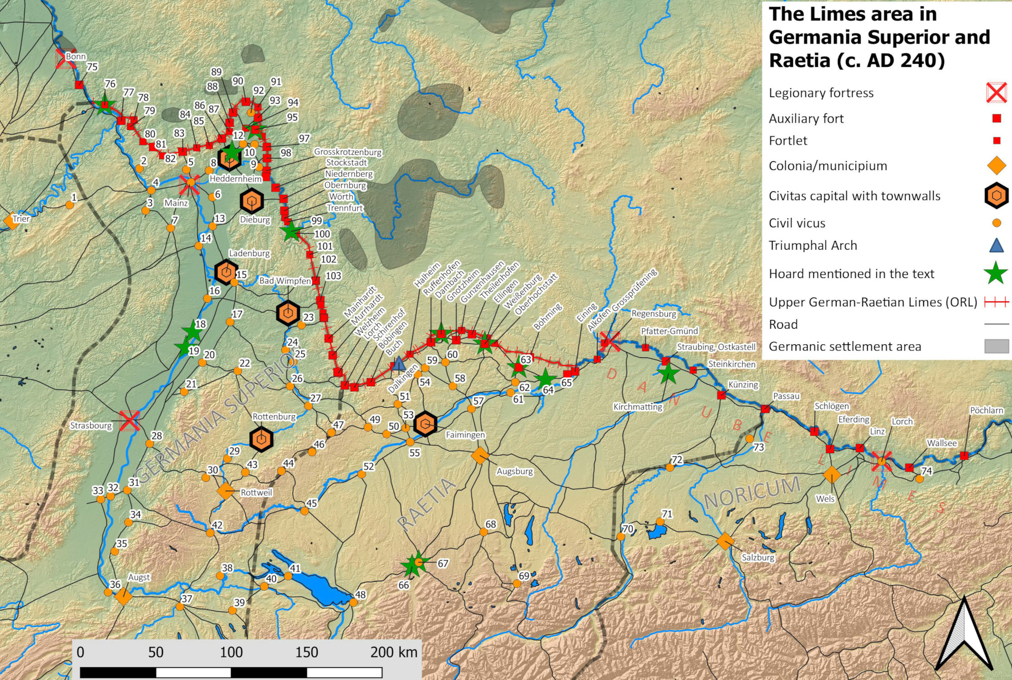
Civil Settlements: 1. Wederath; 2. Lorch; 3. Bad Kreuznach; 4. Bingen; 5. Wiesbaden; 6. Gross-Gerau; 7. Alzey; 8. Hofheim; 9. Hanau-Steinheim; 10. Heldenbergen; 11. Seligenstadt; 12. Karben; 13. Gernsheim; 14. Worms; 15. Heidelberg-Neuenheim; 16. Speyer; 17. Stettfeld; 18. Neupotz (only hoard); 19. Hagenbach (only hoard); 20. Durlach; 21. Baden-Baden; 22. Pforzheim; 23. Neuenstadt; 24. Walheim; 25. Benningen; 26. Stuttgart; Bad Cannstatt; 27. Köngen; 28. Offenburg; 29. Sulz; 30. Schramberg-Waldmössingen; 31. Riegel; 32. Breisach; 33. Oedenburg; 34. Bad Krozingen; 35. Badenweiler; 36. Basel; 37. Windisch; 38. Schleitheim; 39. Oberwinterthur; 40. Pfyn; 41. Konstanz; 42. Hüfingen; 43. Geislingen-Häsenbühl; 44. Burladingen; 45. Mengen; 46. Gomadingen; 47. Donnstetten; 48. Bregenz; 49. Urspring; 50. Langenau; 51. Heidenheim; 52. Risstissen; 53. Sontheim; 54. Oberdorf am Ipf; 55. Günzburg; 56. Faimingen; 57. Burghöfe; 58. Großsorheim; 59. Nördlingen; 60. Munningen; 61. Neuburg/Donau; 62. Nassenfels; 63. Pfünz; 64. Kösching; 65. Pförring; 66. Wiggensbach (only hoard); 67. Kempten; 68. Epfach; 69. Füssen; 70. Pfaffenhofen am Inn; 71. Seebruck; 72. Töging; 73. Pocking; 74. Mauer an der Url. Military Sites: 75. Remagen; 76. Niederbieber; 77. Niederberg Koblenz; 78. Arzbach; 79. Ems; 80. Hunzel; 81. Holzhausen; 82. Kemel; 83. Zugmantel; 84. Heftrich; 85. Feldberg; 86. Saalburg; 87. Kapersburg; 88. Langenhain; 89. Butzbach; 90. Arnsburg; 91. Inheiden; 92. Münzenberg; 93. Echzell; 94. Friedberg; 95. Oberflorstadt; 96. Altenstadt; 97. Marköbel; 98. Rückingen; 99. Kleinheubach (only hoard); 100. Miltenberg; 101. Walldürn; 102. Osterburken; 103. Jagsthausen; 104. Westernbach; 105. Öhringen.
Credits/sources: Ildikó Bősze, Günther Moosbauer (Gäubodenmuseum Straubing), Frederic Auth (Goethe-Universität Frankfurt am Main).
Figure 2: “Suevic tribes storming a fort on the limes”.
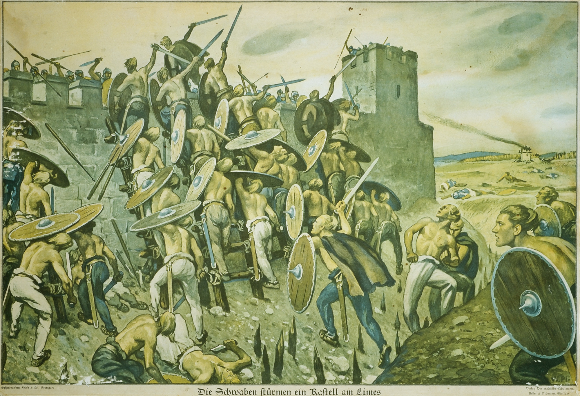
After a drawing by W. Plank, re-edited 1939 by W. Frenzel for the „Reichsbund für deutsche Vor- und Frühgeschichte“ (union for German Pre- and Protohistoric Archaeology of the Reich) for use in schools (Verlag Der praktische Schulmann Nr. 257), Archaeological State Collection, Munich (ASM).
Credits/sources: Manfred Eberlein, Munich.
The historical evolution of the ill-coined denomination “Limesfall”, which implies one or several disastrous attacks by Germanic tribes (Fig. 2) as a monocausal explanation for the Limesfall, was set out in detail by Marcus Reuter2 and Stijn Heeren.3 It is only in the late 20th-century that the Limesfall-theory was questioned more critically, mainly due to the discovery of the Augsburg Victory altar in 1993, attesting a Roman victory over the Germanic tribe of the Iuthungi or Semnones in AD 260.4 More importantly, the Augsburg inscription also attested that the province of Raetia was part of the Gallic Empire of Postumus at the time the altar was set up and was later reconquered by Gallienus. This fact led to discussions on whether the well-known archaeological destruction horizons in Roman forts along the ORL, especially at Niederbieber (Germania Superior), may actually be the result of the civil war between the two rivals for the throne. However, the presumptive undermining of the southern tower at the west gate of Niederbieber cannot be interpreted as evidence for an intra-Roman siege of this fort during the civil war between Postumus and Gallienus or during a Germanic attack.5 From the late 1990s onwards, after Nuber (1990) had defined the end of the Upper German-Raetian limes as a challenge for further research, it became clear that the end of the limes in both provinces, Upper Germany and Raetia, did not occur simultaneously and must be seen in the background of the Empire-wide political, military, and economic crisis.6 Kos aptly pointed out that there is no numismatic evidence for a broad Germanic devastation of Raetia around AD 259/260.7 Marcus Reuter,8 on the basis of the numismatic and archaeological evidence, concluded that the destruction of the Raetian limes was most likely to be dated around AD 254.
In his groundbreaking article Christian Witschel (2020) established a methodology for proving Germanic incursions in the Rhine-Danube provinces, by combining the few literary and epigraphic sources with the archaeological and epigraphic evidence, without getting caught in the trap of circular reasoning. The most recent summary of the status quo of research can be found in Moosbauer (2022), whereas Hartmann (2022) provides a concise summary of the Empire-wide military and political crisis in the 3rd century AD.
From the Severan boom to dwelling in ruins
In the 3rd century, the limes region underwent a rapid development in every respect: between its heyday in the early 3rd century and the final abandonment of the Roman provincial territories east of the Rhine and north of the Danube, there were only two generations. This did not happen in isolation from Empire-wide developments,9 but hardly any other region of the Roman Empire can be said to have experienced such a vicious cycle which may have been driven by the disastrous interactions of civil wars, external threats (Germanic tribes, troop withdrawals), economic crisis and changes in population and society. During the long-simmering civil war between the “Central Empire” and the so-called Gallic Empire AD 260-274, the limes region became a buffer zone between the power blocs, without either gaining the upper hand. Rather, the latter tried to appropriate the remaining resources from the no-man’s land.10 Despite various studies with comprehensive critical assessment of sources,11 not all processes and phenomena are understood today. Several new excavations are only accessible in preliminary reports. In the following, a brief overview of the last phase of the Upper German-Raetian limes will be given highlighting significant phenomena.
The Severan boom
Septimius Severus was the undisputed victor of the civil war of AD 193-197. However, the victory came with a heavy burden: the military, especially the powerful frontier armies, had finally become the mainstay of imperial power. Severus relied on military strength: the urban troops were doubled, new troops were raised, the pay was doubled in AD 197 and increased again by 50 % in AD 212 by Caracalla.12 In this way, he sent signals of deterrence to potential external enemies and was able to act domestically as a guarantor of security and stability as well as the divinely ordained protector of the orbis terrarum and Romanitas (Fig. 3).13
Figure 3: Rome, area of the Porticus Octaviae: Severan marble relief with (most probably) the frontiers of the Roman Empire surrounding the Imperial eagle sceptre.
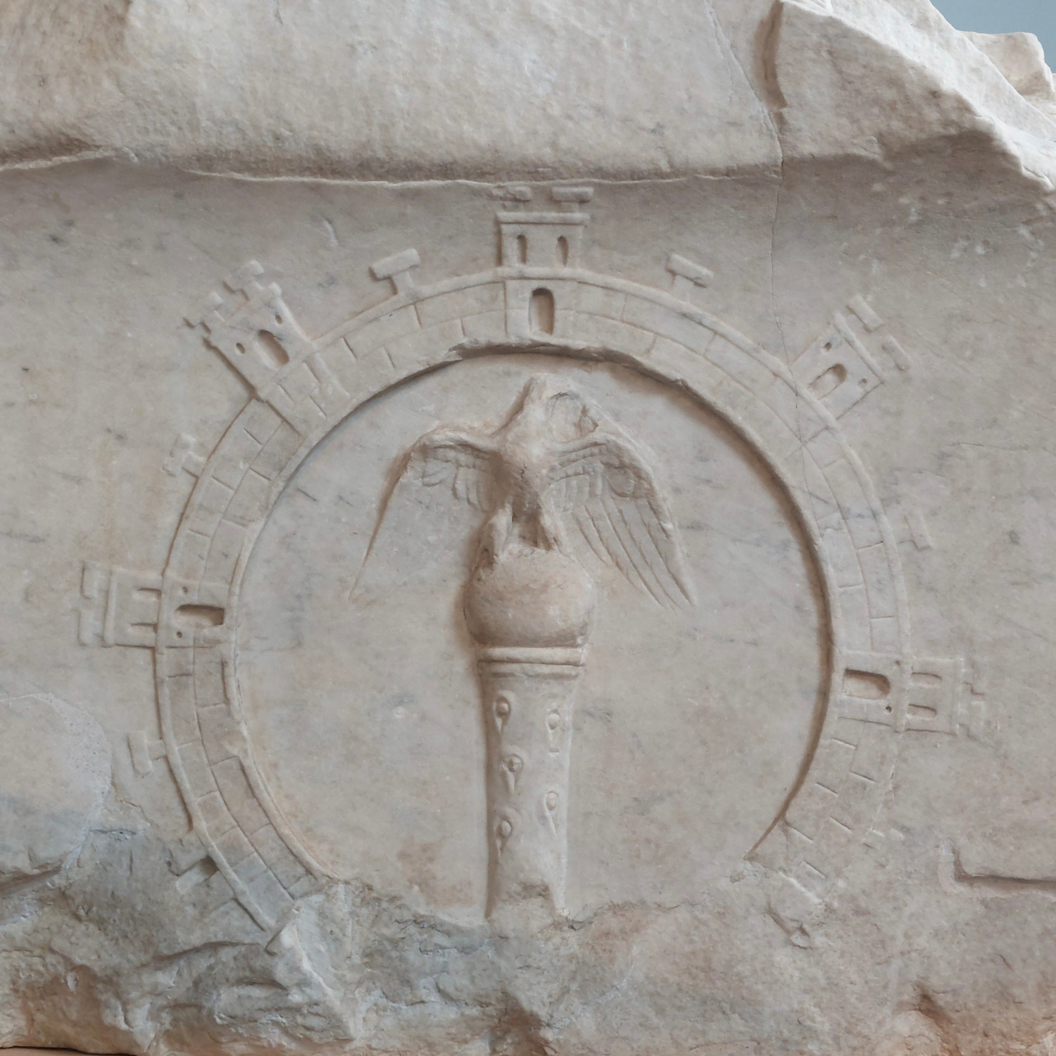
Credits/sources: Christof Flügel, Munich. Museo Centrale Montemartini Rome, Inv. TM 2172.
The Severan reinforcement of the border fortifications across the empire can be easily traced at the Upper German-Raetian limes. New research shows that the limes was by no means as successively and uniformly developed as previously assumed by archaeologists. Rather, for a long time it seems to have been more of a patchwork of regional sections with different structural implementations of the barrier and surveillance installations.14 Nevertheless, the Severan investments in the border fortifications are clearly reflected in the archaeological and epigraphic evidence. From the winter of AD 206/207 onwards, the Raetian wall was erected, while in Upper Germany the most recent, largely continuous expansion phase with ditch and rampart can only be roughly dated to the first third of the 3rd century. While the renovation of the forts and the replacement of their ramparts with stone walls in Raetia was largely realised under Commodus (as a consequence of the Marcomannic Wars), it was carried out in Germania Superior under the Severans (Fig. 4). At the northern Upper German limes, the forts of Niederbieber and Holzhausen were established. The Niederbieber building inscription of AD 193/194 and its position near the provincial border to Germania inferior points more to potential rivalry between the two provinces than to any Germanic threat (Germanic settlements are far away from this region, at least according to current state of research). The garrison of Niederbieber was the 1000-strong numerus Germanicianorum Divitiensium, a mobile deployment of the type of force that later operated throughout the empire. Several forts were significantly enlarged in the course of the stone-building phase to accommodate troop reinforcements (Arzbach, Bad Ems?, Hunzel, Kemel, Heftrich, Kapersburg, Inheiden? and Altenstadt). To what extent this also applies to the exterior limes in today’s south-western Germany is still unclear, since the chronology of the forts at Westernbach as well as Öhringen West and East have not been clarified, for example. In Raetia, discussions continue about the date of the foundation of the forts of Halheim and Mögglingen around AD 200.15
Figure 4: Distribution of building inscriptions of a/ Commodus (AD 180-191) and b/ Septimius Severus (AD 193-211) on the limes between Germania superior and Pannonia inferior.
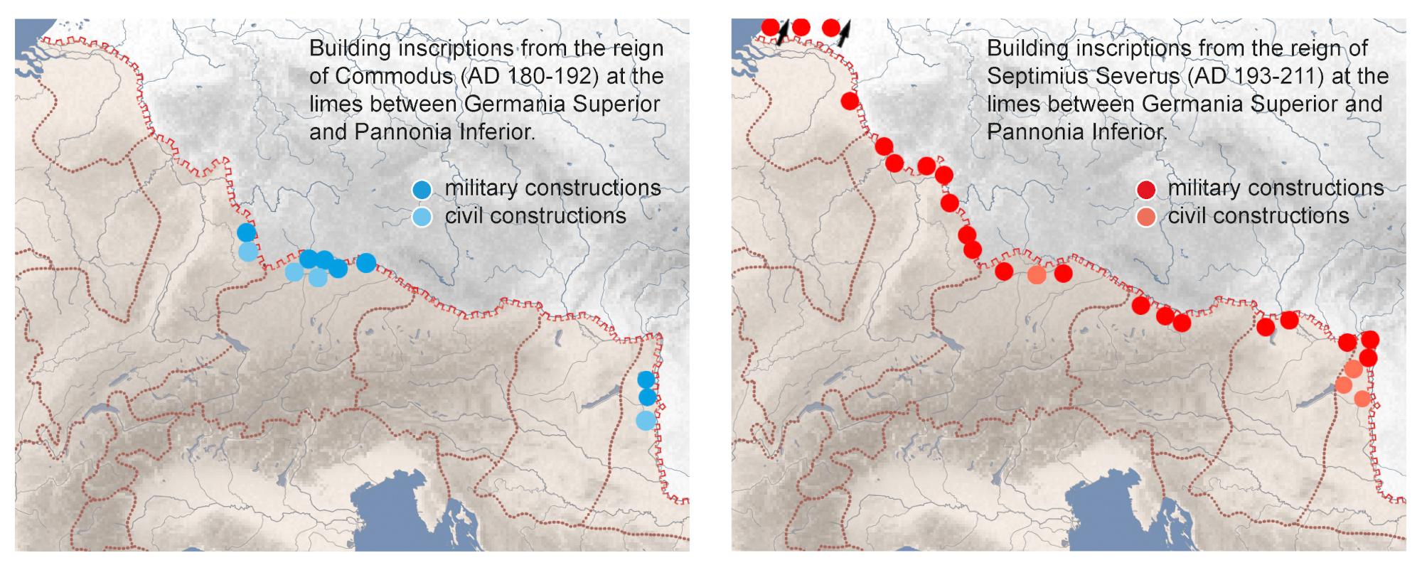
Credits/sources: M. Scholz, K. Engemann, Goethe-Universität Frankfurt am Main, database EDCS.
In Severan times, the limes probably meant more than “merely the visible component of Rome’s power-political and administrative expansion”,16 rather as the resolute military protection of the provincial territory and the exclusion of the barbarians. Series of milestones attest to the renovation of the road network, first in AD 195, 201 and 212 in Raetia, between AD 202 and AD 209 finally in Germania Superior. All these measures brought an economic boom to the border zone in Germania Superior and Raetia. However, this so-called Severan prosperity unfolded unevenly.17 For example, money flowed into religious votive dedications, especially into Jupiter columns18 and altars, the latter also as an endowment privately financed by the soldiers in the forts.19 Neither in the hinterland of Germania Superior nor in Raetia is this trend so clearly reflected. In Raetia—as in eastern Gaul, but again unlike in the Upper German limes area—richer people tended to invest in (modest) grave monuments. Several auxiliary vici—based on those investigated in the peripheral areas of the two frontiers—reached their greatest extent, but did not all experience significant stone building phases as a sign of prosperity.20 In contrast, the development of other hinterland vici stagnated or collapsed, as at Walheim, Lahr-Dinglingen, Güglingen, Heidenheim an der Brenz and even the colonia Augusta Raurica/Augst.21 Representative stone buildings of this period were mainly built in the cities and civitas-capitals. In the countryside, the picture is ambiguous: on the one hand, some magnificent conversions and extensions of larger villas took place, but on the other hand, practically no new dwellings were founded, which may be due to stagnation of economic vitality or population.22
The expeditio Germanica of Caracalla AD 213
The extent to which there were building measures or even a building programme in the context of Caracalla’s Germanic campaign remains debatable. According to Cassius Dio,23 Caracalla himself repeatedly ordered during the campaign: “here a fort is to be built, there a city”. The expeditio (“special military operation”) Germanica was the first (attested) military confrontation in the forefront of the limes for about 40 years, since P. Helvius Pertinax cleansed Raetia from barbarian invaders in AD 171/72 during the Marcomannic Wars. Caracalla’s motives have not been handed down, but are today seen more in terms of domestic political goals than in a pre-emptive strike against a real threat from Germanic tribes. A short, victorious summer campaign beyond the Raetian and Upper German limes was to bring the prestigious victorious title of Germanicus and contribute to the consolidation of imperial power. A call for help from allied Germanic tribes on the middle course of the river Main may have served as a pretext.24 In any case, the expeditio Germanica was lauded in epigraphic propaganda.25
The routes of the expeditionary corps of at least 10,000 men, which included vexillationes from Germania Superior and the Danubian provinces, are unknown. In the Raetian deployment area, at most two 5-6 ha undated marching camps near Lauingen on the Danube and Ohmenheim on the Swabian Alb can be considered in this context. In Germania Superior, as well as between the limes and the presumed battlefield at the so-called Maindreieck near the Main ford of Ochsenfurt (Alamannos … prope Moenum amnem devicit),26 any evidence of a marching camp or battlefield is so far lacking, although several advance routes, possibly used by different marching columns, can be taken into account.27 Although a significant number of honours and dedication inscriptions reflect the campaign, only a milestone series on the road along the northern bank of the Danube AD 212 specifically refers to the improvement of the infrastructure. Gilded bronze letters known from numerous sites along the Upper German and Raetian limes have long been interpreted as inscriptions to welcome the emperor, whether he actually visited the sites or they were affixed prophylactically in anticipation of a ruler’s visit. To what extent they testify to an inspection tour of the border regions accompanying the campaign remains questionable.28 Conversely, it is also conceivable that these inscriptions of honour were only mounted after Caracalla’s victory.29 This also applies to the multiphase gate complex in the limes at Rainau-Dalkingen, the most plausible place where Caracalla himself may have advanced with his guard per limitem Raetiae.30 The triumphal arch façade, which was subsequently placed in front of the border station and oriented towards a meeting place corresponding with a sacred area (temenos), points to the conversion of the border crossing into a memorial (of the imperial cult).31 The comes Augusti Caius Octavius Appius Suetrius Sabinus, whom Caracalla had promoted to governor of Raetia in AD 213, is a possible initiator.32 Caracalla most probably stayed in Faimingen. Its city walls together with the extension of the Apollo Grannus sanctuary in the early 3rd century are the only known archaeological structures that match the above-mentioned passage in Cassius Dio concerning the order to build cities. Since the emperor was devoted to Apollo (Grannus) something similar is also considered for the presumed civitas capital Neuenstadt am Kocher,33 which he could have visited on his return route to the Rhine. The inscription of another monument ob victoriam Germanicam near Brackenheim-Meimsheim (near Heilbronn) fits this route.34
The Germanic invasion AD 233
The following 20 years of peaceful prosperity ended abruptly. In AD 233, Emperor Severus Alexander in Antioch (Syria) received disturbing news from the governors of Illyricum (here probably an unspecific term for the north-western provinces): Germanic tribes were crossing the Rhine and Danube and devastating forts, towns and villages in large numbers. Even Italy was in danger.35 It is possible that for his Sassanian campaign, the emperor had withdrawn troops from the limes in AD 231 and thus weakened it. The flourishing border areas may have attracted plunderers, but were there more to it than that? Had Caracalla’s successors, overestimating their own strength, neglected their Germanic policy and refused subsidy payments in return for security (as was otherwise customary)? Severus Alexander felt compelled to break off the campaign against the Sassanids. The cries for help may sound somewhat exaggerated, but archaeology can now outline the extent of the incursions quite well.36 Widespread destruction with fire debris can be attested above all in the northern and eastern Wetterau and along the main limes, for example in Butzbach, Langenhain, Echzell, Oberflorstadt, Altenstadt, Heldenbergen, Hanau-Steinheim, Seligenstadt, Obernburg and Miltenberg-Ost and possibly at Saalburg.37 The southernmost known affected location was Walldürn. In accordance with Herodian’s text, traces of destruction are found both in forts (at least 2 alae-, 3 cohort- and 2 numerus-forts) and in vici and villas, and probably even in Heddernheim, the capital of the civitas Taunensium (see below). In contrast to the northern Wetterau, the inhabitants further south were apparently able to bring their belongings to safety in time. Each of the burnt layers in question is methodologically difficult to date, but together, a dense chain of evidence for a destruction horizon emerges.38 The post quos dates of the partially burnt coins are all before AD 232/233. There are no dendrochronological dates at present. Besides traces of violence, the interlocking of material spectra is crucial, e.g. the presence or absence of certain types of kitchen pottery (“weißtonige Ware” versus so-called Urmitzer Ware), with regional differences to be considered. The explanation for the change is seen in a partial collapse of regional pottery, which gave way to imports.39 Whether coin hoards (denarii hoards) reflect barbarian invasion routes or a certain horizon of fear is critically evaluated today.40 A geographical concentration of denarius hoards in western Raetia in the Kempten area remains conspicuous and could possibly indicate an incursion route.
Rome’s counter-attack, which was launched from Mainz in AD 235/236, penetrated deeper into Germania than had been thought before the discovery of the battlefield at the Harzhorn (Lower Saxony).41 Reconstruction began immediately, but in some places only on a reduced scale. Thus, although the fort Echzell was rebuilt, parts of the vicus were not. The vicus Hanau-Salisberg seems to have been abandoned.42 The vicus Heldenbergen apparently remained a ruin site, in which the bones of horses and about 60 unburied men (Germanic warriors?) were left littering the ground, whose skulls indicate weapon impacts.43 Was the battlefield tabooed as a desecrated site? All these features are surprising in view of the previously supposedly prosperous borderland. The shock must have been correspondingly deep. Was there a net decrease in population due to fatalities and emigration after the conflict? As the inscriptions for Maximinus Thrax indicate, reconstruction concentrated on the state infrastructure. The rural villas also seem to have continued to exist in the main. Despite the lack of building inscriptions, archaeological evidence proves that the main civitas capitals received city walls during this period.44 In Dieburg,45 Ladenburg and Heddernheim,46 they cut the foundations of demolished buildings, contain spolia, and/or exclude peripheral vicus-areas from the enclosed space. Even if, as in Heddernheim, an external aesthetic effect by means of red painted joints was used, one can no longer speak of prestige buildings. The situation in Wiesbaden is unclear, but a 3rd century date for the first fortifications cannot be excluded.47 Normally, the municipalities had to bear the construction costs, which many apparently did not succeed in achieving, namely Baden-Baden, Riegel, Neuenstadt am Kocher, Bad Cannstatt, Schleitheim and not even the municipium Arae Flaviae/Rottweil. The exposed fort-vicus of Arnsburg seems to have been protected by a provisional(?) ditch-rampart defence according to results of the magnetometry.48 In Raetia only the municipium of Aelia Augusta/Augsburg49 and Faimingen (see above) received city walls. That economic life inside the newly built city walls recovered, is confirmed by the circulation rate of coins, which after AD 233 collapsed much less in fortified than in unfortified settlements.50 Although the impact of AD 233 was geographically limited, it did initiate a negative development that was initially gradual and inconsistent in its phenomena, then accelerated from the 250s onwards. Therefore, AD 233 is widely recognised as the beginning of the end of the limes area.51 In the following discussion the major archaeological factors are presented that contributed individually and in combination to the downward spiral of the limes. A linkage with historical events is only exceptionally possible and fails primarily due to methodological dating problems: the decline of inscriptions; and upheavals in coinage, such as the lack of fresh monetary supply and changes in treasure hiding practices. Closely related to this is the lack of precision in dating the material culture c. AD 260-300 (see below, Last Signs of Life).
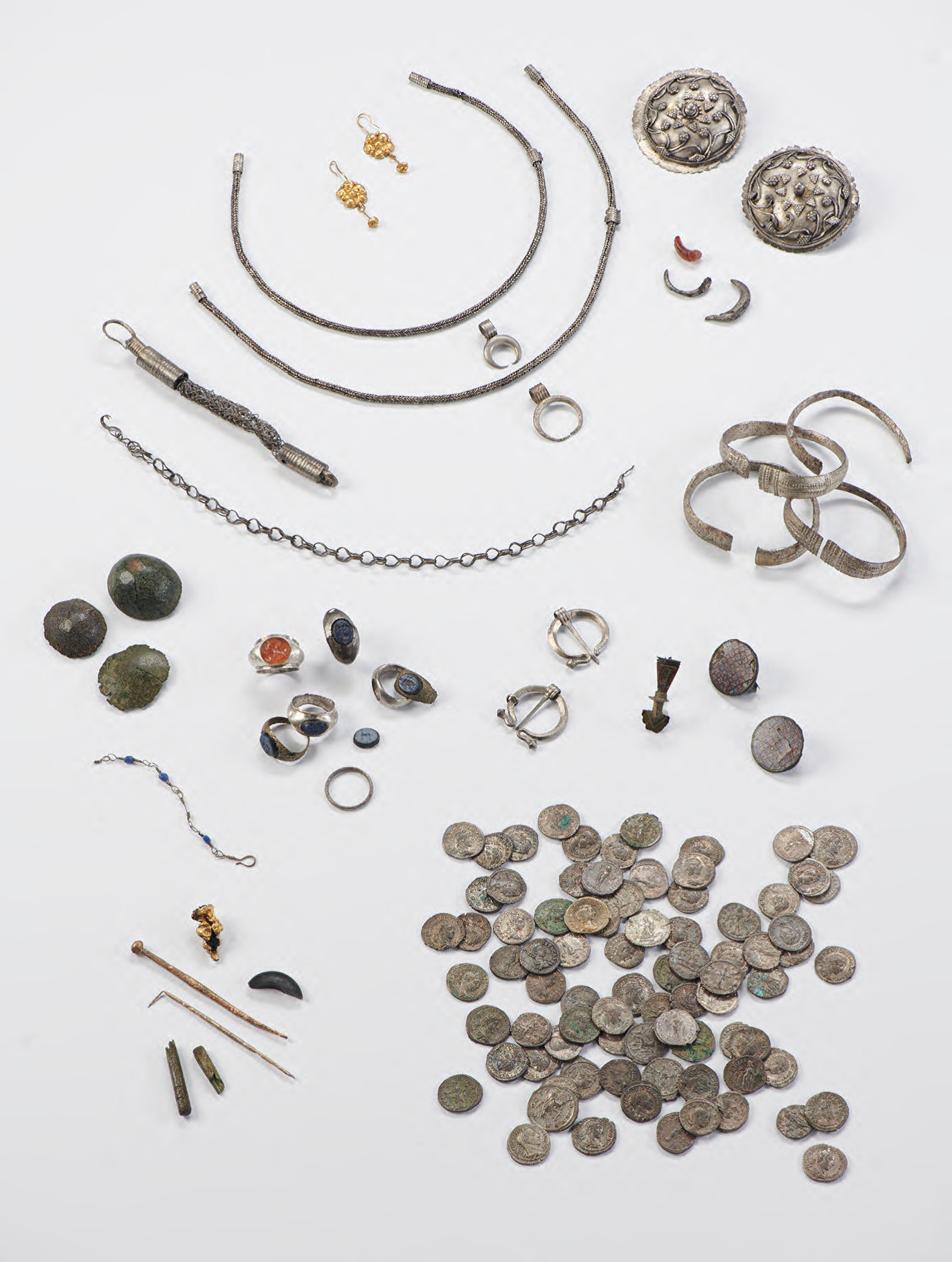
The extent of the Germanic incursions into Raetia around AD 23352 remains under discussion. On the basis of coin hoards, it seems that the regions east of the river Lech and at the Bavarian Alpine rim were especially affected. An outstanding example of a hoard attributed to this period is the treasure of Wiggensbach near Cambodunum-Kempten in southern Bavaria (Fig. 5).53 This hoard, besides women’s jewellery and silver fibulae, contained 407 silver coins, indicating a date of deposit around AD 233. The Wiggensbach hoard is a good example of an Angsthort, hidden with the intention of saving objects of personal wealth for a better future in times of political and military crisis.
Figure 5: Wiggensbach near Cambodunum-Kempten: Hoard of jewellery and coins, dated AD 233.
Credits/sources: Stadtarchäologie Kempten i. A.
The composition of a contemporary metal hoard from Kempten,54 containing fragments of 18 bronze vessels as well as 43 metal objects, due to the wide chronological range of the vessels, dating from the 1st to the beginning of the 3rd century AD, was interpreted as a Roman scrap metal depot hidden during the AD 233 Germanic incursions. It was found in a cellar of an insula, destroyed by fire in the first half of the 3rd century AD.
Battlefields and combat
In the limes area, there are few features in the correct sense of battlefield archaeology, but there are various traces of combat. Niederbieber was the only limes fort to perish in battle and to be abandoned along with its vicus without the battlefield being cleared.55 On the basis of four coin hoards with final issues of AD 254-259 and the coin series, the armed conflict is dated to AD 260. As the fort is located on the provincial border between Germania Superior and Germania Inferior, it has been historically associated with the usurpation of Postumus in Cologne.56 The objection that the hoards could also have been hidden on the occasion of a troop withdrawal in AD 26057 does not have to apply to all hoards. Among other things, the lack of coins of Postumus in Niederbieber speaks against destruction as late as around AD 274 or 280/281.
In addition to the above-mentioned vicus of Heldenbergen, weapon fragments in combination with human bones and burnt debris in the area of a pottery on the northern edge of Heddernheim are also associated with the warfare of AD 233.58 Similar evidence applies to Pforzheim and a road station at the mouth of the Kinzig near Hanau-Steinheim.59 In front of the southern tower of the annex fort at Osterburken, early 20th century excavations revealed numerous human bones and over 120 projectile points, mainly of Germanic origin. They show impact traces and testify to an attack on the fort after AD 244/249.60 The mixture of skeletal remains, weapon parts, and final burnt layer suggests fighting, e.g. at Mainz-Kastel61 and in the vicus of Weißenburg i. Bay.62 Traces of combat have also been observed along the Raetian limes,63 for example at Pfünz, where a chained prisoner in the principia met his death during the final destruction of the fort after AD 242/244, also attested by human remains in the south-eastern tower.
The destruction of the Raetian limes in AD 254
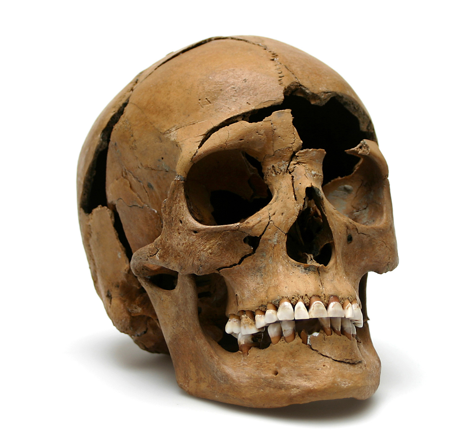
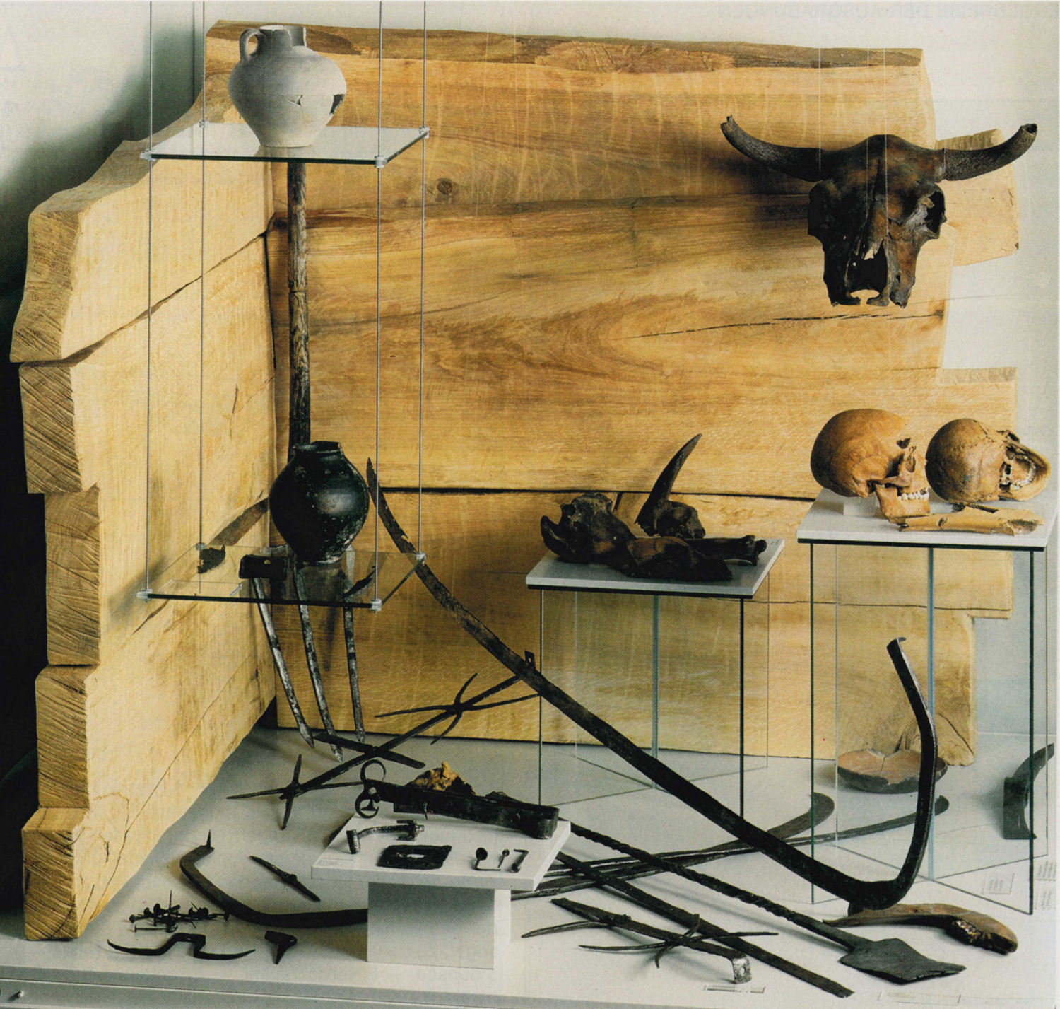
Extensive destructions, dating around AD 254, have been archaeologically documented in nearly all of the forts of the northern Danubian Raetian limes between Schirenhof and Pförring.64 However, these Germanic incursions were not limited to northern Danubian parts of the Raetian limes area, but also affected the adjacent Raetian Danube limes between Eining and Passau.65 The backfill of two wells in the villa rustica of Regensburg-Harting (6 km south-east of the legionary fortress of Regensburg) offered a glimpse into the brutal past in eastern Raetia during the uncertain times of the mid-3rd century AD.66 They contained skeletal remains of 13 adult individuals (well I: 9 persons; well II: 4 persons). The skulls show predominantly fatal blow traumas on the front (Fig. 6). Anthropological analysis proved that the bodies were already partly decayed, before being disposed of into the wells. Some skulls additionally demonstrated traces of scalping, which was interpreted as evidence for the ritual killing of some individuals. The backfill of the wells also contained deposits of agricultural and domestic iron objects, as well as construction iron, all items being found below the aforesaid skeleton strata (Fig. 7; reconstructed backfill of well). This is clear stratigraphic evidence for a two-phased deposition process with different responsible actors. Whereas the deposit of iron tools, coming from different spheres of daily life, is most likely to be attributed to Germanic looters immediately after the raid, hiding the booty with the aim of recovering it later, the corpses of the murdered inhabitants of the villa rustica appear to have been thrown into the wells by Romans cleaning up the massacre crime scene at some time later. It appears that wells were often used to dispose of non-articulated dead bodies; a similar example is known from well 32 in the vicus of Weißenburg with parts of three individuals.67
Figure 6: Regensburg-Harting, skull with deadly blow on the forehead from a well in the villa rustica.
Credits/sources: Manfred Preischl, Museen der Stadt Regensburg.
Figure 7: Regensburg-Harting, reconstruction of the backfill of a well in the villa rustica in the former BMW-Museum Regensburg.
Credits/sources: Manfred Preischl, Museen der Stadt Regensburg.
The massacre of Regensburg-Harting must be seen in context with large-scale destructions in the auxiliary fort of Regensburg-Großprüfening as well as in the legionary fortress and the canabae legionis of Regensburg68 and in eastern Raetia in the mid-3rd century AD. During these Germanic incursions, numerous settlements were destroyed, including the auxiliary fort of Straubing-Ostkastell III, home of the Syrian cohors I Flavia Canathenorum milliaria sagittariorum, and other forts on the Raetian Danube limes, like Künzing, and settlements in the hinterland, like the vicus of Pocking.69
A similar clean-up scenario as in Regensburg-Harting was observed at the vicus of Rainau-Buch at the western end of the Raetian limes.70 Three wooden wells, dated to AD 203 (well 13) and 229 respectively (wells 7 and 9), contained wooden elements felled in winter 253/254 and yielded three hoards with large amounts of bronze vessels, bronze and wooden figures from lararia and Roman militaria as well as iron tools. The three hoards on the well bottoms were sealed with a thick stratum of debris, evidence that the vicus had been cleaned up after its extensive destruction in AD 254.
Population and society in the Upper German limes area during the 3rd century
The material culture is dominated by late La Tène elements with (Elbe-)Germanic influences. Scholars assume a rather thin settlement of heterogeneous and rather poor groups. Traces of the indigenous pre-Roman population are even more difficult to find in the later limes period. Similar methodological dating problems arise for the second half of the 1st century BC as for the second half of the 3rd century AD. On both sides of the Rhine lived a mixed population that can hardly be separated archaeologically into “Germanic” and “Celtic”, especially after the resettlements of the Ubii, Nemeti, Vangiones, Triboci and possibly Mattiaci.71 Along the eastern Upper-Rhine valley, militant groups of Elbe-Germanic character were settled from the first half of the 1st century AD onwards, to which the name of the civitas Sueborum Nicrensium (“Neckarsueben”) was given. Clearly identifiable is the immigration from (eastern) Gaul from Flavian times onwards, mentioned by Tacitus.72 Both the permanent deployment of auxiliary troops on the limes since about AD 110 and the predominantly local recruitment practised from this time onwards promoted the emergence of a border society that was originally multi-ethnic, but now focused on the army and the state. Structurally and economically, it was largely oriented towards the military and its needs. Contacts in Germania were part of this society, including labour migration (possibly seasonal harvest workers).
Severan politics brought changes. Raises of soldiers’ pay and legal privileges at first consolidated the frontier society (see above, Severan boom). In AD 197, Septimius Severus is said to have allowed soldiers to live together with their partners outside the camp, even if not in legal marriage.73 From the early 3rd century onwards, even active soldiers were allowed to acquire land.74 The epigraphic habit of endowing votive monuments in suo, literally translating as “on own soil”, attested for the first time in AD 201 and mainly in the northern limes area and in the surroundings of Mainz, reflects these privileges.75 The general granting of citizenship to all freeborn inhabitants of the empire in AD 212 (Constitutio Antoniniana) yielded ambivalent consequences.76 On the one hand, it created legal certainty and forced the internal integration of the empire and a lasting identification with the Romanitas by formally levelling the legal status differences between cives Romani and peregrini (freeborn inhabitants of the provinces without Roman citizenship). On the other hand, it thereby eliminated the previously effective incentive to earn citizenship through endowments and social commitment (local elites) or 25 years of service in auxiliary troops. This stifled an engine of social dynamism and increased government expenditure. Heising77 notes a general retreat into privacy in the early 3rd century. The Constitutio Antoniniana entailed tax increases that exacerbated social discrepancies between old and new citizens. Indicators of farm abandonment and the formation of large estates in rural settlements point to a widening social gap.78 Among the beneficiaries were financially strong veterans and “crisis profiteers” of the political purges after the civil war of AD 197. These had mainly affected the elites of Gaul, but perhaps also some in the limes region.79 Such concentration processes could have intensified after the impact of AD 233 and possibly led to social tensions. Traces of vandalism on cult monuments and other symbols of power do not necessarily have to be attributed to looting Germanic tribes, but could also be traced back to angry mobs.
The influx of new groups and foreign trends changed society. After the civil war, the Rhine army was replenished with troops loyal to Severus from the Danubian and Balkan provinces to compensate for losses with loyal Severan followers.80 At the same time, cultic and cultural influences from the Orient increased, possibly favoured by the Syrian origin of the imperial family. The interdependence of these external influences with the Constitutio Antoniniana favoured a new phenomenon: the differentiation and articulation of regional identities, sometimes referred to as the “Celtic Renaissance”.81
The military society, in which state subsidies (pay, privileges) played a significant part in holding it together, must have been shocked by the Germanic invasion in AD 233 and the collapse of the Severan dynasty. Even more, the repeated troop withdrawals may have destabilised the economic and social fabric. From inscriptions in Mainz in the 3rd century, which were donated by members of military units and officials (ordo decurionum) on the eastern bank of the Rhine, we can assume a steady movement of the elites away from the frontier regions.82 They might have used their regional network to bring family members to safety as a precautionary measure.83 At the very least, the exodus of capital and investors is to be expected. However, there are also counter-examples. In Nida, stone sarcophagi only appeared in the second third of the 3rd century. Burial customs and grave goods in the densely occupied inhumation cemetery at Frankfurt a. M.-Praunheim attest to a wealthy social class in Nida in the second half of the 3rd century, which participated in the current trends on the left bank of the Rhine.84
In Germania, too, momentous changes loomed from about AD 200 onwards. In Main Franconia in particular, there was an increase in the density of Elbe-Germanic settlements. The immigration, possibly triggered by a worsening of the climate in northern Central Europe, probably increased the pressure on the Germanic tribes living in front of the limes and created new political groupings, or constellations of previously discrete groups.85 The fact that these turned out to be capricious from the Roman point of view may also be attributed to an ambivalent Germanic policy: on the one hand, military strength and demonstrative exclusion of the barbarians were relied on, on the other hand, increasingly federated Germanic tribes were recruited into the limes units.86 The increase in troops, a possible reduction in the attractiveness of service in the auxiliary troops as a result of the Constitutio Antoniniana (new citizens were allowed to join the legions) as well as a possible stagnation in birth rates87 may have necessitated the immigration of “skilled workers”. This development seems to have intensified after the troop withdrawals and population losses from the mid-3rd century onwards. Even before that, an increasing number of finds of (Elbe-)Germanic provenance can be found in Roman settlement contexts, both in forts and in civilian settlements.88 A mid 3rd century fashion to name persons after wild animals (e.g. Aper, Lupus, Ursus) corresponds with the simultaneous occurrence of Elbe-Germanic animal-shaped brooches. If there is a connection, it would indicate processes of integration in action.89 Presumably, the immigrants were able to build on existing contacts with groups of Germanic origin already resident in the limes area.90 Changed dietary practices left traces in the pottery: bowl and cup shapes dominate, traces of use increase, even in vessel types that were not actually intended for this purpose. Are these traces of impoverishment or a new (Germanic?) table culture? Conversely, ethnic conflicts are also conceivable.91
When the limes area became a no-man’s land between the civil war fronts in the 260s, Postumus seems to have extended the influx of Germanic foederati as a buffer into the northern limes area.92 The settlements followed a Germanic tradition distinguished by houses with integrated stables (“Wohnstallhäuser”) and sunken pits. They developed in the vicinity of Roman settlements, continuing to use springs, fields and raw materials.93 Roman ruins, however, were rarely reused for Germanic settlements, as for example in Wurmlingen,94 perhaps because the technical skills were lacking, the will to reoccupy ruins, or both. From the late 3rd century onwards, new tribal names such as the Burgundiones emerge under the leadership of reges or reguli as actors vis-à-vis Rome. Whether the first mention of the Alamban(n)oi (Alamanni?) as a new self-designation of an anti-Roman coalition in AD 213 in Cassius Dio95 is authentic or not remains controversial. Currently, the ethnogenesis of the Alamanni from Germanic groups in the former Roman provincial territory at the end of the 3rd century is assumed.96
One can speak of a certain continuity of the settlement, but not necessarily the population. After AD 260, provincial Roman culture becomes practically invisible to archaeology. The explanations for this are multi-causal: migration and evacuation; death by violence and epidemics;97 impoverishment and declining life expectancy;98 and kidnapping by Germanic raiders.99 The fact that the settlements on the western side of the Rhine shrank contradicts the idea of larger waves of refugees from the abandoned limes area.100 However, archaeology generally faces methodological difficulties in making poverty visible, for example in the case of favela-like settlements, if such existed. This overall situation provides a reason to discuss the possibility of the assimilation of remnants of the Roman population into a now Germanic-dominated society.101 However, the complete abandonment of the Roman way of life within one generation seems difficult to imagine. There is a significant break with tradition concerning the way pottery was made and its typology.102 The evaluation of post-limes period coins remains controversial as an indicator of residual Roman or partially Romanised Germanic people. They often originate from Germanic settlements and only partly reflect small change circulation in low quantities on the western bank of the Rhine.103 At least in the Wetterau, partially Romanised Germanic tribes of the limes period are possible tradition-bearers, who copied barbarised small change (so-called minimi radiati) and possibly used Roman “cultural markers” such as mortaria and nails.104 So far, Roman settlers can only be verified in the area of Wiesbaden and until AD 280/290 in the southern Upper Rhine Valley.105 The influx (still controlled by Rome?) continued from east to west in the 4th century.106 In 2020, a Germanic cemetery of the late 3rd to 5th century with 215 cremations and 43 inhumations was excavated at Rockenberg. The poor, shallowly buried cremations were preserved here by chance under a colluvium.107 They highlight what was probably lost elsewhere.108 A new elite is only revealed by inhumations and hilltop settlements from the late 4th century onwards.109
Population and society in Raetia
Overarching studies of the population in Raetia have recently become a research focus in Bavaria, starting with the question of assimilation and acculturation of the Celtic inhabitants immediately before and after the occupation in 15 BC.110 The first- and second-century Roman population of the province was the subject of a large-scale research project of the Deutsche Forschungsgemeinschaft (German National Research Council), published in 2022,111 using the cemetery of Günzburg as a reference group for extensive archaeological, anthropological and bioarchaeological analyses. This endeavour was completed by the analysis of the late Roman cemetery of Günzburg in comparison with late antique graves from the province of Raetia Secunda.112 However, comparable large-scale analyses of the population are still missing for the 3rd century AD in Raetia. Therefore, as this province and especially the limes area is generally poor in inscriptions,113 we basically have to rely on inscriptions of the capital of Augsburg to gain insight into the Roman society in Raetia in the 2nd and 3rd centuries AD.114 However, we have to bear in mind that the demographic situation at Augsburg as the capital115 and the seat of the provincial governor116 was certainly different from that in the rest of the province. The commercial life at Aelia Augusta is for example attested by an ex-member of the imperial guard, who started a second professional career as a textile trader after his retirement, a pork dealer and member of the city council and traders in ceramics and wine. These professionals were supplemented by people associated with the governor’s office like an advocatus fisci or an attorney at law. It seems that Augsburg reached a heyday in the Severan era, judging by huge building projects. This fits the general picture of large public investments in infrastructure in Raetia under the Severan dynasty.117
Reduction, improvisation and conversion
In both the military and civilian sectors, one repeatedly notices conversions that had the effect of reducing or repurposing buildings.118 The background is to be found in population decline, dwindling economic power and resources, but also in adapted efficiency. The substitution of expensive Spanish olive oil with locally produced plant oils for fuelling oil lamps may be due to increased prices for imported Spanish oil in times of reduced economic possibilities of the population in Upper Germany.119 In the southern limes area, an earthquake in the 240s seems to have further aggravated the situation.120 The abandonment of facilities is evident in a variety of ways, e.g. improvised workshops in former supply buildings as in Aalen,121 walled-up gates or dumping in fort ditches.122 In the numerus-forts of Kapersburg, Miltenberg-Ost, and Wörth(?), there was probably the installation of fortlet-like internal fortifications in one corner while retaining the fort walls. All these measures indicate a considerable reduction in troop strength. Their dating causes difficulties. In Miltenberg-Ost, the conversion probably took place immediately after the destruction of AD 233, all other measures can only be roughly dated to the 2nd third of the 3rd century. Therefore, it remains unclear whether there was a building programme behind them or whether they were improvised local measures. These interventions in the fort structure were far-reaching and never reversed. The decision to make these changes must have been made when a return to former conditions and thus to the original personnel strength was not feasible. According to one hypothesis, this could have been the case from Gordian III onwards, when, after repeated troop withdrawals, soldiers no longer returned or returned only in part to their former bases.123 A heterogeneous picture emerges of how attempts were made to adapt the surveillance system to the shortages. Significantly, in the north-western Taunus limes, which was probably considered less endangered and the last to have been reinforced in Severan times, the traces of reduction are most evident. No site of numerus-size or larger was apparently abandoned, but this is partly the case with watchtowers and fortlets.124 At the Wetterau-Limes, on the other hand, numerous fortlets seem to have offered an adequate operational size.125 Possibly they increasingly served as bases for cavalry patrols. In parallel, isolated burgus-like new buildings were erected, e.g. at Kapersburg126 and at Glashütten in the high Taunus; the latter contained a tetradrachm minted in AD 268/269, one of the latest coins found in situ on the limes.127
The withdrawn troops must not only have been incorporated into expeditionary armies, but could also have been partially stationed as mobile intervention reserves in the hinterland (horsemen). A few late gravestones of cavalry soldiers suggest this hypothesis, whereas finds of militaria are of little value in helping us resolve this issue.128 The 5 ha stone fort at the Danube ford of Faimingen, which was partly built from spolia of the temple of Apollo and probably never completed, may have been designed as the last fort of ala II Flavia p. f. milliaria.129 On the eastern Raetian limes, the lack of personnel may have led to the shortening of the surveillance line between Weißenburg and Eining.130 In Miltenberg-Ost, a small bath was built over levelled barracks. In conjunction with female-specific finds, e.g. at the centuria fort of Haselburg, it can be assumed that the free space in the forts offered protection to civilians.131
Deconstructions and improvised repairs affected both military and civilian bath buildings. The tendency suggests that at first the lukewarm and sauna rooms (tepidaria and sudatoria) were abandoned, but with the frigidaria and caldaria the basic operation was maintained.132 Repairs to hypocausts with building rubble and even with limestone instead of bricks are frequently observed. The conversion of individual baths into workshops or modest dwellings could represent a final stage, e.g. Zugmantel, Saalburg, Kapersburg, Weißenburg, and Lauffen am Neckar. The various deconstruction techniques can be impressively traced in the baths of Schleitheim. Even representative administrative buildings fell into disrepair or were converted, such as the so-called monumental building of Heidenheim (Fig. 8),133 administrative buildings in Baden-Baden,134 or the Riegel basilica.135
Figure 8: Heidenheim an der Brenz (Raetia), praetorium (so-called Monumentalbau), 3rd c. reduction-phase.
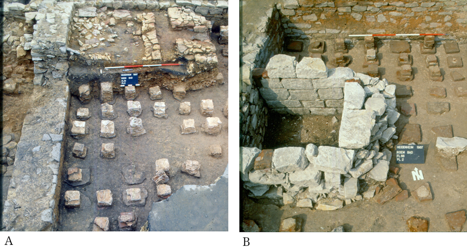
A/ The hypocaust heating of a reception room was levelled and a grain drying kiln erected above in a corner of the room (on top). B/ A small cellar was cut into the levelled hypocaust-heating using spolia.
Credits/sources: Landesamt für Denkmalpflege Baden-Württemberg, Esslingen.
In some vici, uninhabited former residential areas or the abandonment of (peripheral) quarters is noticeable, e.g. in Heddernheim and Riegel.136 In the fort-vicus Echzell, even strip houses in lucrative locations in front of the main gate of the ala fort fell into disuse after AD 233 (creation of an extended glacis?). The Saalburg-vicus apparently shrank considerably.137 Elsewhere, selective activities are recorded in rubble sites, e.g. the former beneficiarii station of Obernburg, Augst, or Baden CH.138 It is often difficult to decide whether these are squatter occupation or simply litter pollution, if, for example, there are no dateable hearths. However, certain tendencies toward neglect and slumming cannot be ignored. Vital infrastructure was partly incorporated into the walled vici. For example, a magazine building was built in Heddernheim, and in Bad Wimpfen an urban dwelling was converted into a farm.139 The abrupt spread in the 3rd century of economical canal heating instead of hypocausts as well as of grain drying kilns seems to be reactions to firewood shortages and climatic changes.140 Harper141 points out that the greatly reduced solar radiation since the 240s led to a noticeable drop in temperature. The coin hoard of Prutting-Mühltal near Rosenheim (Bavaria) at the border between the provinces of Raetia and Noricum contained 1,289 silver coins, lost in a catastrophic flood-water event after AD 238/239.142
Public order and internal security
In many places there are features that indicate unstable conditions. Skeletons of victims of violence are found increasingly in the 3rd century in the limes area.143 Many come from the backfill of wells, cellars, and ditches, quite a few show traces of violence (excesses) or animal scavenging, indicating a longer period of lying in the open (Fig. 9).144 Whether they were casualties, assault victims or crime victims remains to be determined on a case-by-case basis.145 As an example, in Heddernheim there is evidence for the violent assault of three civilians which resulted in their deaths.146 Corpses, animal carcasses, and stable manure were also suitable for wanton well poisoning.147 Hoards are said to indicate unsafe conditions.
Figure 9: Nida/Frankfurt am Main-Heddernheim (Germania Superior), sacred well in the central sanctuary filled with building material including roof slate and several bronze votive objects.
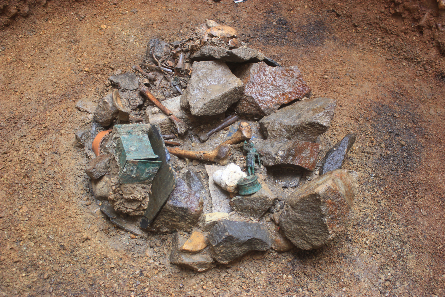
The bronze base of a Mercury-statuette bears an inscription dated to 9th September AD 246. In between lie the bones of a c. 40- to 50-year-old woman. At the very bottom an Antoninianus of Traianus Decius was found post-dating the filling to AD 249.
Credits/sources: Denkmalamt der Stadt Frankfurt am Main 2017.
Interpretation models of 3rd-century hoards
Coin hoards148 as well as bronze vessel deposits149 or scrap metal hoards are main sources to reconstruct Germanic incursions and raids of the 3rd century AD150 and are most commonly divided into “Angsthorte” (hoards concealed in times of danger to hide valuable objects from potential plunderers) and looters’ hoards, which are characterised by a “mixed composition” of objects of value and everyday life and which are interpreted as a result of the acquisition of booty after hostile raids. Altmetalldepots (scrap metal deposits) are quite common along the Upper German-Raetian limes in the third century and have often been attributed to Germanic looters in search of iron for reuse. The booty hoards of Neupotz151 and Hagenbach (Rhineland-Palatinate)152 bear witness to Germanic incursions deep into Roman Gaul and contain predominantly all imaginable types of reusable iron. On their way home, Germanic plunderers seem to have been attacked by ships of the Roman Rhine fleet, resulting in a complete loss of their booty.
Following a reassessment of the so-called Weißenburg temple treasure, which had been interpreted as a looter’s hoard,153 Bernd Steidl in 2021 suggested a new insight on this outstanding mixed assemblage of small bronze statuettes from lararia, silver votives, as well as iron household items.154 They most likely are to be seen against the background of instability and lack of internal security in the province of Raetia, following the withdrawal of various troops (including the ala I Hispanorum of Weißenburg) to support Emperor Valerian’s claim for power and his imminent Persian campaign. Germanic tribes took advantage of this situation and attacked the limes region as early as the summer of AD 254. The Weißenburg hoard is to be interpreted as the result of an individual’s “anti-social behaviour”, taking advantage of the afore mentioned lack of internal security to secure his future in the face of missing personal prospects. The criminal intention in assembling the Weißenburg hoard is best proved by the fact that the hoard contained various objects coming from temples or domestic sanctuaries. The question of who was responsible for putting together this remarkable collection of objects in the Weißenburg treasure, remains open, but on the basis of the outlined social and cultural explanatory model a Roman provincial inhabitant of the Weißenburg military vicus seems to be most likely while Germanic plunderers can be ruled out.
Steidl’s new interpretation model can easily be applied to other hoards in the ORL region, for example the bronze vessel hoard from Dambach,155 one of the neighbouring forts of Weißenburg on the Raetian limes. This hoard, which had been unearthed as long ago as 1852, contained, besides a frying pan and a hot-water jar, a set of two jugs and two beaker-like smaller vessels of the so-called type “Dambach”156 which are believed to have been used in the context of Roman cauponae. Besides the bronze vessels, the Dambach hoard also contained two small bronze spoons (ligulae) as well as a handle, which may have belonged to a wooden chest used for hiding these objects. All vessels show heavy traces of use and multiple ancient repairs. It may be that these vessels were removed from a Roman tavern in the eastern vicus of Dambach (although the standard publication in the ORL cites them as coming from the fort, but the first publication of 1855 shows that the vicus cannot be ruled out). Some of the closest parallels for the Dambach vessels occur in the Weißenburg hoard, linking both hoards to the “Limesfall” crisis of AD 254.
Examples of 3rd-century hoards in the limes area
The composition of the numerous hoards of denarii must be carefully considered, taking into account general collection and accumulation practices, the change to an irregular largely interrupted money supply in the mid-3rd century AD and the circulation of old and barbarised (improvisational) money as a result of the decreasing silver content of new coinage.157 In addition, however, there are material hoards that can be explained by the hasty concealment of household goods or artisan materials, e.g. in Pforzheim,158 Rainau-Buch and Heidenheim.159 The dredged finds from the Rhine gravel near Hagenbach and Neupotz are considered prime examples of Germanic looters’ booty.160 In the turmoil of Germanic invasions and civil wars, some provincials might have enriched themselves, as Gregor Thaumatourgos describes for a Gothic invasion in AD 256.161 A revision of the heterogeneously composed Weißenburg treasure, which also includes material from a temple, points to a vicus inhabitant as a looter who had survived the AD 254 catastrophe.162 Deposits of non-ferrous scrap metal testify to the plundering of settlements, which did not even spare monuments. The crushing of imperial statues and parade armour for melting down even in limes forts may testify to poverty, personal gain and anarchy or at least to a lack of new metal supplies and limited economic networks.163 In conjunction with shattered or desecrated images of the gods, however, the question of a profound change in mentality arises. Had the numerous damnationes and civil wars contributed to the loss of respect for state representatives and gods? Two neighbouring hoards in Frankfurt a. M.-Niedereschbach support the assumption that this phenomenon was rampant in the final phase of the limes area.164 Could the exploitation of ruins be regarded as robbery? The omnipresent residues of metal recycling by improvised workshops that nested in all sorts of buildings fit the scrap collection.165 Iron depots that also contained building materials likely testify to forge supplies or plundered ruins. It is possible that some were only gathered in the post-limes period.166
As a result of both the increased power and the utilisation of the military, abuse of authority, soldiery, and desertion increased in the 3rd century, even if concrete evidence from the limes area is lacking.167 On the other hand, the finds from civilian settlements show tendencies towards (self-)armament.168
Last signs of life
In AD 253 Valerian usurped in Raetia and went into civil war with the bulk of the limes forces - with fatal consequences. Archaeology reveals that the Raetian limes and its hinterland were destroyed and abandoned as a result of a widespread Germanic invasion in AD 254.169 In contrast, the Upper German limes area saw a gradual decline in the second third of the 3rd century, accompanied by regional outbreaks of fighting. In contrast to the Raetian limes area, where with the exception of the problematic Gallienus building inscription from Hausen ob Lontal170 no post-Severian inscription is available, a successive retreat of state organs into the Rhine Valley can be perceived in the Upper German limes area on the basis of the dated inscriptions (Fig. 10; maps inscriptions 235-176). Perhaps the highways were maintained the longest if milestones are not regarded as mere statements of loyalty. The latest inscription was made by the civitas Taunensium at Friedberg.171 The construction of the Mainz city wall from AD 253 (felling dates of the pile foundation) probably may have been an immediate reaction to the destruction of the Raetian limes, even if a direct link cannot be proved.172 As a result of (modern) destruction and erosion, the most recent traces of a settlement are often no longer preserved or are difficult to recognize and interpret—poverty often eludes archaeology. Especially in the cities, however, a peculiar phenomenon looms. The final backfilling of numerous cellars and wells was carried out intentionally and often quite carefully, usually after the ruins and their debris had been searched for usable material.173 In the course of this, stone votive monuments were (ritually?) buried, partly after being vandalised, especially Jupiter (giant) columns.174 Likewise, human remains were disposed of in the process, often after a certain period of decay in the open air, and without apparent reverence (Fig. 9).175 In Heddernheim, even the foundations of the central sanctuary were dragged out thoroughly, leaving their trenches systematically filled with chipped mortar and wall plaster—a feature that differs significantly from all post-Roman stone robbing activities.176 The strong impression is that the estates in question were to be prepared for new constructions, which never took place. When this levelling and debris removal took place and who initiated it remains questionable. Does this indicate an attempt at a new beginning that was cut off by a final evacuation order? In Neuenstadt am Kocher, an unworn antoninianus of Tacitus (AD 276) came to light in situ in the intentional rubble filling of a spring basin in the Apollo Grannus sanctuary.177 Is this a feature of the temporarily successful reconquest attempt under Emperor Probus AD 277-278?178
Figure 10: Dated inscriptions AD 235-276 in Germania Superior and Raetia.
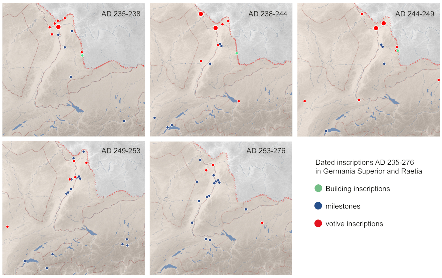
The concentration of milestones on the Neckar-mouth is due to milestone deposits in Heidelberg and Ladenburg. These milestones obviously belonged to the eastern Rhine valley road. Moreover, they may indicate the significance of the Neckar river as well as the road connection between the Rhine and the Danube near the ford of Gontia/Günzburg (transitus Guntiensis) until the last days of the Agri Decumates.
Credits/sources: M. Scholz, K. Engemann, Goethe-Univ. Frankfurt a. M., database EDCS.
Due to the revision of old finds as well as stratified new finds, in total enough coins of the minting period AD 260-276 are known,179 so that—unlike in Raetia (the final coins from Roman contexts in the limes area were minted in AD 253)—it is no longer possible to maintain the stereotype of “Limesfall” AD 260. The ceramic type spectrum of the Niederbieber-horizon can be extended at least to the time around AD 290/300.180 Innovative types of this period are mainly represented in regional nigra vessels.181
A final abandonment of the Upper German limes area under Aurelian or Probus is still under discussion.182 The possibility of a short-term (restricted?) reoccupation of the limes or continued occupation of individual sites into the 4th century is also considered mainly on the basis of a few but consistently found small metal finds but rarely of ceramics.183 There is no evidence for a real continuity of settlements on the right bank of the Rhine, with the exception of Wiesbaden.
Danube-Iller-Rhine limes
The loss of northern Raetia and its frontier region in AD 254 would have exposed the eastern flank of Germania Superior, but there are no archaeological indications that steps were taken to close this gap. The end of the Raetian limes, as well as the contemporary construction of the Mainz city wall, may have caused or led to an increase in the flow of refugees from the abandoned territory into Upper Germany. During the civil war of AD 260-275, each side extracted resources from the limes territory for the last time. Germanic settlers may have moved in to occupy this abandoned land, as seems to have been the case at Wurmlingen184 and in the Wetterau. Late milestones from the confluence of the Neckar and the Rhine together with late (but imprecisely dated) cavalry tombstones point to some military activity at the Rhine fords, including Worms, and in the hinterland of the Upper German limes. In Raetia the Hausen ob Lonetal inscription, together with the late (and unfinished) fort at Faimingen, indicate protection of important Danube fords. Systematic protection of the upper Rhine valley and the upper Danube is not attested before c. AD 280/290.
In this period new fortification measures can be traced along the southern Rhine. A fragmented building inscription from Vindonissa mentions in AD 260 a murum [--- manu] militari restitue[runt …].185 In Augst the Kastelen-plateau next to the abandoned Forum was fortified with a c. 10 m high wall using spolia.186 Similar walled enclosures were built on both the Münsterhügel of Basel and the Münsterberg of Breisach, the latter being at that time an island in the Rhine.187 The murus Vitudurensis at Oberwinterthur188 was in AD 294 probably the last to follow in this new group of fortified settlements on the Upper Germanic side of the newly established Danube-Iller-Rhine limes. The further development in the 4th to 5th century has recently been summarised.189 The situation further north is not (yet) that obvious. Strasbourg and Mainz remained legionary bases.190
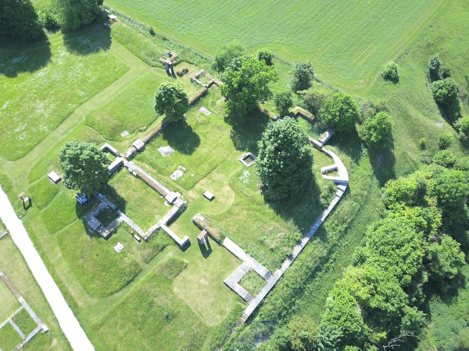
Marcus Reuter191 pointed out that there is no evidence for Roman or Germanic settlements in the northern Danubian parts of the Raetian limes immediately after the 254 destruction. It appears that Raetia was merely an area through which Germanic raiders passed through en route to Italy. The civil population retreated into fortified hilltop settlements, like the Moosberg near Murnau, south of Munich, or temporarily the Rinkenburg hill near Ravensburg (Hansen et alii 2023, p. 203). It appears that some groups took temporary refuge in caves, for example in the Swabian Alb or in the Kampenwand near Aschau (unpublished). After further Germanic incursions in the 270s and 280s AD in eastern Raetia, for example at Regensburg and surroundings,192 the systematic reorganisation and sustainable fortification of the Raetian frontier to compensate for the loss of the agri decumates did not occur until around AD 300, notwithstanding some minor military installations already constructed under the Emperors Probus and Aurelian, for example at Isny-Bettmauer as well as Burghöfe, where the Via Claudia Augusta as the main connecting route between Italy and Raetia reached the Danube. The post-“Limesfall” military history of Raetia from AD 300 onwards has been summarised by Mackensen (2018) and for this reason need not be repeated here in detail. The newly aligned Diocletianic frontier, which followed the course of the main rivers and excluded the former Raetian territory north of the Danube, was named the “Danube-Iller-Rhine limes” by Jochen Garbsch. The new Tetrarchic frontier followed the southern shore of Lake Constance193 and the road connecting Bregenz and Kempten, hence south of the River Argen, from where it followed the River Iller (with the fort of Caelius Mons-Kellmünz) downstream to the Upper Danube.194 It then turned eastwards, following the Danube. The new frontier consisted either of newly built forts, like at Kellmünz195 or Günzburg196 or made use of previous military structures: At Abusina-Eining, a small fortification was set into the north-western corner of the middle imperial auxiliary fort (Fig. 11). The new Danube-Iller-Rhine limes protected the hinterland of the province of Raetia Secunda. Contemporary with the first Diocletianic fortresses along the new defensive line are the first Germanic settlements in the former Roman territory north of the Danube. This phenomenon can probably be explained by a new Roman security concept in front of the new frontier.197
The Danube-Iller-Rhine frontier was subsequently strengthened, especially in the course of a large military building programme under Emperor Valentinian I, which also comprised fortifications far away from the actual frontier line, like the quadrangular fortification with protruding square towers at Aying near Munich, which is thought to have had the function of a military supply base, probably not finished in Late Antiquity.198
Figure 11: Neustadt a. d. Donau-Eining: Drone photograph of the late Roman reduction fort in the north-western corner of the mid-imperial auxiliary fort of Abusina.
Credits/sources: Erik Dobat, Edufilm und Medien GmbH, Bad Bleiberg (Austria).