
Introduction
The world of Roman borderlands offers a series of unparalleled features to explore the interaction between communities, economy and state authority. The impact of Rome at the edge of its Empire varies abundantly, and this peculiarity generates complex scenarios, which differ through time and space. Studies carried out on the German and other northern limites have highlighted how the imperial strategy of Rome was adapted and—in cases—converted and modified to fit into the particular socio-economic and cultural texture of these liminal zones.1 Regional variability and different urbanisation patterns impacted abundantly on the economic landscapes of Roman borderland areas, and datasets for the Rhine limes or northern England have enabled historians and archaeologists to draw extremely interesting conclusions about population growth, economic impact and settlement dynamics.2
As a negative counterbalance to this (relative) abundance of records, data from the eastern frontier of the Empire are very limited and show a low degree of comparability. Survey data collected between the 1980s and the early 2000s in North Mesopotamia focused only marginally on the Roman period—there was a major interest in the Bronze and Iron Ages—and with little or no systematic data processing attached. This has inevitably resulted in the disproportion of available evidence between the pre-Classical and the Classical world for a very important region for Roman political, military, and economic activities with notable global and trans-imperial connections.3
In Syria, where most efforts were directed toward the construction of military architecture and infrastructure, as well as into the establishment of an urban administrative and taxation system through coloniae, the structures of empire—administrative, economic and military control—were in place, and where soldiers were attested, evidence of Roman official presence (public buildings, baths, Latin inscriptions, etc.) is also documented. This is not the case of Roman Mesopotamia, where the archaeological visibility of the Roman Empire and its impact—both militarily and economically—is more nuanced, and not easily discernible. For this reason, this study aims to reconsider the economic and political role of North Mesopotamia in the period between the 2nd and the 4th c. AD in this paper. Detailed analysis of the establishment or collapse of Roman imperial control of this frontier region is not feasible at present due to the state of evidence. Rather, the impact of major centres on the economic landscape of the imperial borderland will be explored, as well as the peculiar social milieu of the communities living and exploiting the territory, and the role of the route network as a means to increase mobility and economic activity, also enhancing the relationship between cities and villages (also including nomadic communities).
Setting the stage: borderlands and the geography of Roman Mesopotamia
Borderland areas present a perfect framework for the exploration of phenomena of interaction and engagement between different groups and communities. Often, in such zones, there are established examples of bilateral interplays and mutual approaches. Modern scholars have discussed borderlands as areas where no major power imposes a solid political and economic dominion.4 Equal processes are recognizable in several peripheral areas of the ancient world, where the elusiveness of the imperial central power gave birth to the non-mediation of the authority, which outsourced the control of such areas to local elites. Borderlands are indeed particular spaces of communication, cooperation, and negotiation, that can take the form of military confrontation, economic and state dependence/collaboration, and religious conflicts/hybridisation. In the complex panorama of the Roman Empire and its related expansion in the Near East, these specific borderland phenomena assumed a particular role, and one that needs a fuller attention. The idea itself of a limes in North Mesopotamia and trans-Euphratene region is challenging and its interpretation—if any—relates to what Isaac pointedly highlighted some decades ago.5 He claimed that the term limes never indicated structures like walls, forts, and camps (i.e. Hadrian’s Wall is never referred to as a limes), but rather, and especially from the 1st to the 3rd century CE, it is simply employed to define a border area with no reference to military organisation or physical boundaries (i.e. rivers, mountains, etc.). With the worsening of the frontier policy in the later Roman Empire, and the increase of the building activities to secure the borderland areas, the physical aspects of the limes regained a prominent role. And yet, the absence of a real physical barrier and the lack of a systematic defensive system are the main features of Roman Mesopotamia. Until and after the Augustan period the Euphrates was seen as the demarcated border between the Roman and the Parthian Empire. With the military advancement towards the eastern steppe under Trajan and more substantially in the Severan Age (late 2nd-early 3rd century AD), the physical aspect of the barrier became more transitory, fluctuating in a wider buffer zone between the Upper Khabur River in Syria and the western bank of the Tigris in northern Iraq. Here cities with long pre-Roman tradition, Aramaic-speaking communities, and non-sedentary groups negotiated space and society among themselves and with the newly arrived Roman military units. The management of the fragile landscape of North Mesopotamia, its geography and space, was a key aspect for the coexistence of diverse communities in this area, where social and cultural overlaps occurred on a daily basis both at the urban and regional levels.
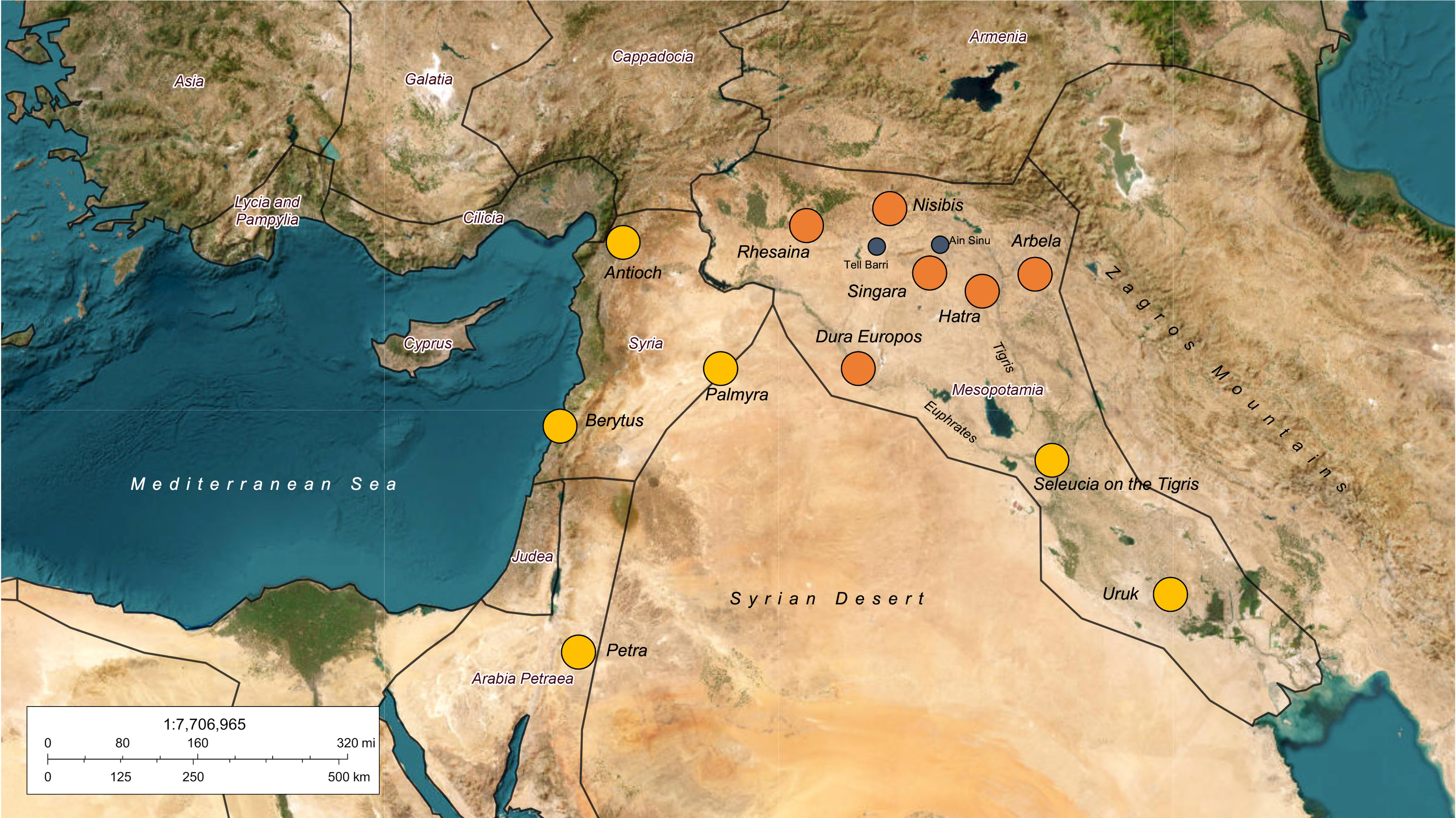
Before proceeding to the analysis of the economic and social landscape of the easternmost territory of the Roman Empire, it is therefore necessary to briefly set the spatial stage properly. With Northern Mesopotamia, we refer here to the region currently comprised between north-eastern Syria, north-western Iraq, and part of south-eastern Turkey. Defining its limits is not straightforward, but it can be understood in general terms as the land located between the area east of the upper courses of the Euphrates and the Tigris rivers below the Anatolian plateau, together with the northern margins of the Syrian Desert between Syria and Iraq (Fig. 1). At certain points in the Roman period, this large area encompassed part of the province of Coele Syria, a part of the territory under the control of the kingdoms of Osrhoene and Armenia (to the west and north, respectively) and part of the kingdom of Adiabene to the east.6 This political fragmentation was probably the result of a later accommodation of pre-Roman polities dominating their own territory, co-opted by the Romans for the control of the steppe lands beyond the Euphrates, throughout the whole period of Roman presence, with varying success (Fig. 1).7 The area that became a province under Septimius Severus is roughly defined by the limits of this geographic shelf which also correspond to the 200-mm rainfall line, below which agriculture is possible only with artificial irrigation and labour investments. All major settlements (Rhesaina, Nisibis, Singara) lie above this line, and within the northern, extended, basin of the Khabur River, the major tributary of the Euphrates in the region (the other, shorter and with a more seasonal character is the Balikh to the west).8
Figure 1: Part of South-West Asia and Greater Mesopotamia with the indication of sites mentioned in the text.
Credits/sources: Rocco Palermo.
Urban economy: cities on the fringe
Major studies on the Roman presence in the steppe-lands of North Mesopotamia have mostly concentrated on the historical and literary evidence, with the archaeological record only minimally included in the discussion.9 This is partly due to the fact that an effective set of archaeologically reliable data is indeed missing, but also to the scholarly tradition that has generally relegated the study of the Roman easternmost frontier within the larger discussions on the Roman Near East, with Mesopotamia being de facto a small and very much peripheral area of the vast Roman Eastern Mediterranean. The evolution of settlement patterns in the Roman period and Late Antiquity has been rarely explored for the broad region and, with the sole exception of the exploration carried out by David Oates in the 1950s at Ain Sinu and Singara, detailed urban landscape studies have been only recently applied to the Roman (and Parthian) period.10
Survey projects carried out in north-eastern Syria and north-western Iraq since the 1980s have had limited success in demonstrating the transformation of the landscape of settlements in the Hellenistic, Roman and later periods. On the one hand, this was due to the limited interest of many projects in the so-called post-Assyrian periods (roughly from the 6th century BC to the rise of Islam), while the scanty available records to be used in a comparative perspective with surface-collected evidence further discouraged those interested in the reconstruction of the Seleucid and Roman involvement in the urbanisation/ruralisation processes in the region. This difficulty in examining and analysing data has also generated confusion in regard to the terminology employed for the period covering the early centuries of the 1st millennium AD. Terms like Parthian-Roman, Hellenistic-Roman, or even 1st millennium AD [sic!] were widely used in publications and field reports, creating undiscernible groupings of archaeological material that cannot be differentiated.11 This lack of interest for the Classical Age in Mesopotamia has resulted in an absence of reliable datasets, limiting our understanding of historical and archaeological dynamics, resulting too often in a confused patchwork of information that requires time and too much speculation to achieve a sense of comprehension. This scientific impasse has dominated for so long that new projects operating in the greater area of North Mesopotamia are revolutionizing our perception of the extended eastern borderland of the Roman Empire and its role as a zone of interaction between multiple imperial agents.12
It is a truism, however, that the definition itself of Roman settlement in the region is challenging. With this caveat accepted, the available evidence for the rural and urban settlement of Roman Mesopotamia is presented, with a particular focus on the economic phenomena as retrieved from textual and archaeological data.
The starting point is the definition of main and minor, as well as urban and rural, as it can be applied to the contested landscape of Roman Mesopotamia. A main centre, usually an urban site, can be defined as a relatively large city that almost certainly played a significant role in military, economic, and social processes, represented by the concentration of trading activities, different craftsmen, and by its predominant role in the regional and trans-regional route network. According to these categories, there are three major centres: Nisibis, Rhesaina, and Singara.
Besides these urban centres, small villages, hamlets, isolated farms, and other rural communities also populated the Mesopotamian landscape, along with seasonal camps of non-sedentary groups. All these categories must have interacted—on a rather mutual level—with large cities, and yet the social and economic dependencies of these sites need further explanation. Did these rural communities occasionally interact among themselves by somehow bypassing the major centre(s)? The answer is probably positive as many rural communities in antiquity acted along a double channel sustaining, at the very same time, both the major centre(s) and themselves. On the other hand, supplies coming and going from a rural area did not all reach the urban centres, and in the same way not all goods available in the community arrived from cities. Thus, the exploitation of the rural landscape functioned relatively equally as a major benefit for the smaller communities within the political and economic orbit of the largest and most important cities.
In terms of social stratification, major cities tended to be populated by “globally” oriented societies that defined themselves through broader value systems, created market exchanges, and managed the majority of the economic processes at both the local and regional spheres. The countryside’s response to the market-oriented major centres generated a series of economic specialisations that fostered the importance of the rural zones in relation to the major urban areas.
Unfortunately, in North Mesopotamia there is not sufficient evidence to suggest precisely what kind of social milieu was dominant in the major centres, but some suggestions can be made nevertheless. Was Nisibis, for example, once it had become a colonia, a “Rome-oriented” centre? To what extent was the administration of Nisibis influenced by political interests along the limes? At what level was the impact of Rome recognised by local communities, and traceable in the available evidence from the major centres?
Urban areas, although limited in number compared to other eastern regions, constituted the core of the consensus within the limits of the eastern borderland. This is displayed in the adoption of certain values of external origin in terms of religion, architecture, economy, and administration that mingled well with the local substrate and persistent local traditions to create the socio-cultural panorama of Roman Mesopotamia. The negotiation of these values shaped the social and physical features of each city; taking place at different levels, this particular mediation is visible through major categories of evidence such as environmental factors, politics, strategic relevance, and the economy.
All three major centres, Nisibis, Rhesaina, and Singara, lie in a steppe land area that covers a substantial part of North Mesopotamia, and therefore they share a common geographical setting that includes the presence of waterway(s), springs, and arable lands in the immediate proximity. The common ecological features are reflected in their rather similar importance in terms of political control. Rome’s influence in the Mesopotamian borderland was particularly visible in this roughly triangular area whose vertices were the major urban centres. These acted as key loci for the maintenance of imperial control, and their role as trading points and commercial hubs also affected the economic landscape on a regional scale.
After the peace treaty of 292 AD between Narsai and Diocletian, for example, only Nisibis was granted the permission to establish trade exchanges with Persia (and beyond), a fact that reflects both the relevance of the city itself and the particular role that the urban hubs had in the developing economy of Roman Mesopotamia.13 Prior to this phase, Nisibis and Rhesaina, not too distant from each other, interacted in terms of economic interests, territorial control, and strategy within the political context of Rome’s influence in the area.
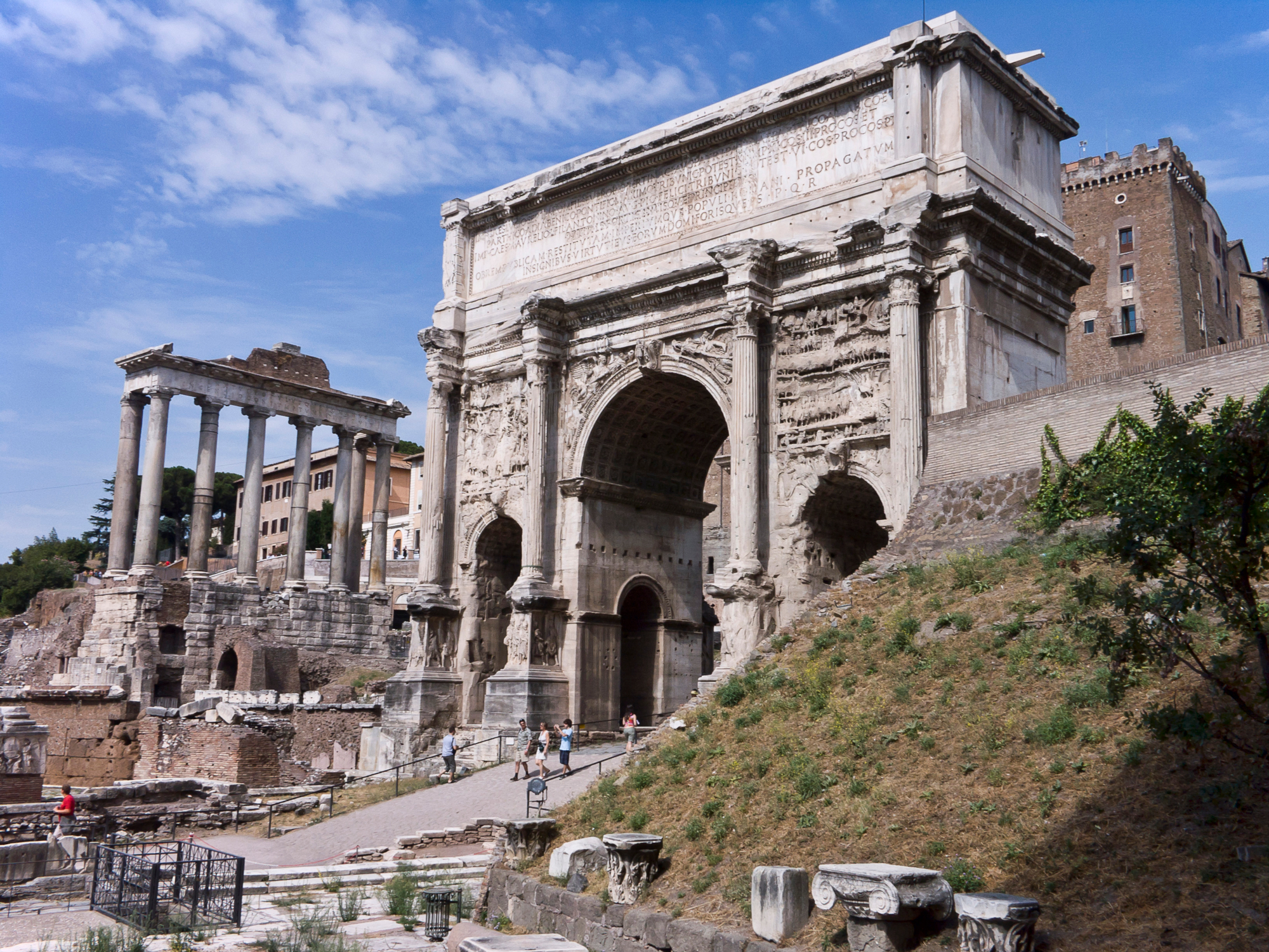
In terms of the impact of empire, expressed, for example, through the presence of substantial architectural features, major cities of the region acted differently from other cities of the Roman Near East. We can assume that, and perhaps because of the particular political scenario of the region, they must have looked like fortified cities. Indeed, among the large cities of the region, only at Nisibis is there no clear trace of its massive defensive walls, but one can certainly infer their existence; they are depicted on the Arch of Septimius Severus in Rome (Fig. 2). The fortress of Nisibis and its defensive walls are also mentioned by Ammianus Marcellinus (History, XXV, 7, 9) among some of the most important strongholds of Mesopotamia. The imposition on the supposed ancient site of the modern centres of al-Qāmishlī (Syria) and Nusaybin (Turkey) has certainly contributed to the obliteration of the majority of the archaeological remains.14 Fortified citadels, reinforced gates, and military quarters also characterised the Mesopotamian cities of this period, as well as hydraulic engineering works that contributed to the water supply for their population (see the case of the late Roman/Byzantine cisterns at Dara, not far from Nisibis)15. However, unlike cities in western Syria which were also adorned with temples, palaces, public squares, and rich private dwellings, a planned architectural programme is not visible in Roman Mesopotamia. At Nisibis, the provincial capital from the Severan times until the mid-4th century AD, there are few archaeological remains dated to the Roman period. Corinthian columns are still visible in the no man’s land between Syria and Turkey and they have been interpreted in association with a very fragmented Latin inscription as part of a possible circus located south of the city centre,16 or—less likely—as part of the forum.17 The city started to host a vibrant Christian community from the 4th century AD onwards, and the remains of the baptistery of Mar Yaqub in the modern city centre of Nusaybin (on the Turkish side of the border) bear witness to this phase. Thanks to a very detailed inscription it is possible to date the monument to 359 AD, a mere 4 years before the peace treaty of 363 that marked the end of the Roman presence in the region.18
Figure 2: The Arch of Septimius Severus in the Roman Forum.
Credits/sources: Jean-Christophe Benoist, CC BY 3.0, Wikimedia Commons.
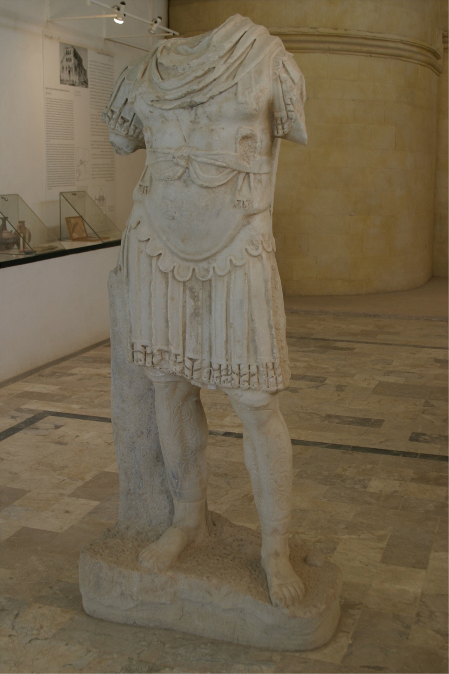
West of Nisibis, the favourable position of Rhesaina on the road that connects the Euphrates region to the Khabur valley, and hence to the Tigris (via Nisibis), was extremely important to the strategic purposes of the Roman rule in Mesopotamia. Its location in a fertile land, rich in water and springs, contributed to the development of the civilian settlement and served to support the military fortress. The elevation of the city to the status of colonia reflects its relevance in terms of territorial control, but it also mirrors the politics of the Severan period, which aimed to make the Roman presence in the region official in consequence of the new territorial acquisition. Rhesaina, like Nisibis, Singara, and Edessa, became a civic mint in the area, thereby directly increasing its own economic impact on the region. Military personnel stationed in the city forced the reconfiguration of the urban space. Part of the Roman period city walls has been unearthed in the modern city of Ras el-Ain (Syria),19 and the incredible finding of a cuirassed statue—dated probably to the end of the 2nd century AD—confirms the enormous political relevance of the city (Fig. 3).20
Singara, corresponding to the modern Iraqi city of Sinjar (or Beled Sinjar, Kurdish: Shingal) has preserved large sections of its late Roman period city walls with U-shaped towers and monumental gates. Excavations and studies carried out by D. Oates in the late 1950s demonstrated a much clearer sense of the ancient urban space and the extent of the fortified town and its supposed citadel.21
Considering this evidence, and taking into account that a significant military presence was attested in these centres on various occasions, one can postulate that despite the absence of significant archaeological or textual evidence, it would be reasonable to suggest that the dynamics of military/civilian interactions observed and evidenced at Dura Europos were probably similar in Rhesaina, Nisibis, and Singara.
Figure 3: The cuirassed statue unearthed at Rhesaina/Ras el-Ain.
Credits/sources: Courtesy of Peter Bartl.
Demography and the agricultural economy in Roman Mesopotamia
An interesting element to determine the economic impact of a colonia at the very end of the Roman Empire is to potentially reconstruct the demographic pressure that the city applied to itself and the surrounding territory. As many of the ancient economic processes were largely dictated by agricultural revenues, the ratio between demography and a city’s potential catchment area is a useful way to assess the spatial (and socio-economic) impact on the landscape.
Several studies have focused on the calculation of demographics and urban demographics, with a substantial number of them dedicated to the Roman world.22 Research conducted within the framework of the Oxford Roman Economy Project shows that an estimated population for nucleated settlements (villages) ranged between 150 and 250 persons per hectare.23 It has also been observed that in Bronze Age Mesopotamia, for example, this range could have varied between 100 and 200 persons per hectare.24 This is largely based on comparative observations of modern rural communities, where building techniques (such as adobe) and household components (enlarged families) have not changed significantly from ancient times.25 Eventually, by combining a Mediterranean with the Near Eastern model, one can assume that a range of 100-200 persons/ha can be also applied to later periods of Mesopotamian history. And yet, the space within a city was not entirely occupied by private dwellings (public buildings, roads, market squares, and open areas were all part of the urban layout), and for this reason, a lower figure would be much more realistic in determining demographic quantities.26
As said, Nisibis, Rhesaina, and Singara were primarily civilian settlements that were adapted to host military quarters, and the case of Dura Europos provides a useful archaeological comparison.27 In this sense, a precise estimation of the settled area is affected by the fact that part of the internal space of the cities was occupied by military structures that might have increased the average in terms of the persons-per-space ratio. The military quarter at Dura Europos, for example, occupied c. 1/3 of the walled space in the northern part of the city, covering an area of approximately 20 hectares. Population figures for the military quarter have been estimated by Simon James at 3,000-6,000 units.28 If compared to the general numbers hypothesised for the civilian part of the city (10,000-15,000),29 this evidence suggests a considerable presence of Roman soldiers (and associated families) at Dura. It is not a surprise then that the involvement of Roman officials in economic transactions and social interactions with local and regional communities was particularly intense.
Turning to Roman Mesopotamia proper, a similar methodology to assess population figures and catchment areas will briefly be used. We will thus focus on Singara as the test case here, as its archaeological remains can be used to suggestively determine the size of the ancient city, in a better and more complete way than Nisibis or Rhesaina. The walled area of Singara covers an approximate area of 17 hectares, which means that, considering the low range test parameters, it could have hosted approximately 1,700 inhabitants, a number that seems relatively low for a “city”; whereas if one assumes the highest parameter, the population of Singara might rise to c. 3,400, which fits particularly well—proportionally—with the calculation already proposed for Dura Europos. Starting from the very end of the 2nd century AD, Singara became the headquarters of the I Parthica, one of the two legions deployed in Mesopotamia by Septimius Severus.30 This evidence suggests that the population could have increased by at least 4,000 units—but higher numbers are more likely. Considering that there is no evidence of an external fort/camp at Singara, one must think that Roman soldiers were hosted within the city walls, following the model that we have already illustrated for Dura Europos. At this point, Singara would have a potential population of c. 6,000-7,500 people. These figures are very well within the scale of a mid-to-large settlement in pre-industrial societies, as rightly pointed out by A. Bowman and A. Wilson.31
Eventually, this increase in population was necessarily tied to a stronger pressure on the potential agricultural catchment area, whose effective exploitability must have represented a great impact on the general economic life of the city.
Indeed, demography—and particularly demography in the ancient world—is considered a key element for understanding of multiple and complex economic processes.32 Usually, significant intensifications in economic activities during the classical/late antique period in Mesopotamia can be directly correlated with an increase in the size of settlements.33 And indeed, archaeological surveys carried out in the large area from the Upper Khabur basin to the Tigris have demonstrated that the “Age of the Territorial Empires” (the Assyrians, Seleucids, Romans, Parthians, and Sasanians) went hand in hand with a steady intensification of urban and non-urban settlements, despite the natural curves and the inevitable periods of political instability.34
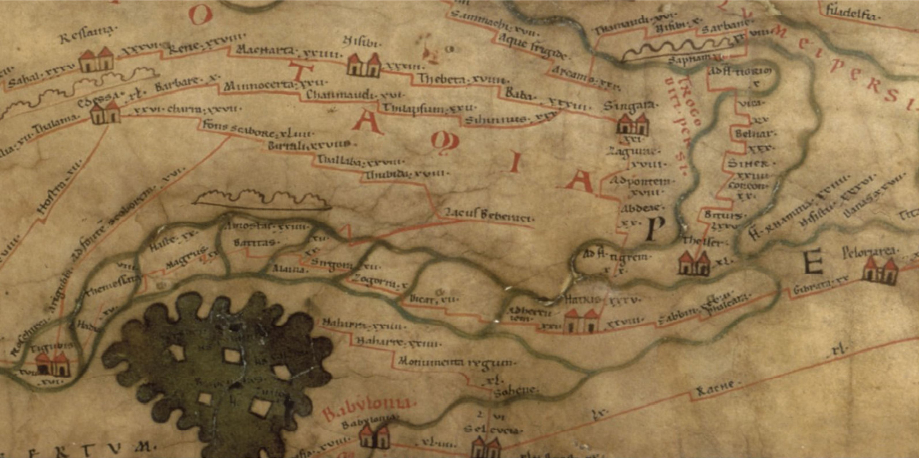
Naturally, each major centre of the ancient world was not isolated or detached from its own regional landscape, and assuming that the parameters used to estimate the supposed population of the large centres of Roman Mesopotamia are valid, the next step is to define their possible catchment areas. These zones represent the expendable agricultural potential of each city. A model to calculate the extension of a city’s agricultural sustaining area in the fragile landscape of North Mesopotamia has been formulated by the late T. Wilkinson.35 This is based on the assumption that a single person eats approximately one hectare’s worth of grain or cereals per year (on the basis of a fallowing regime, which can be adapted to the particular ecological context of North Mesopotamia).36 According to these figures, the catchment area of Singara, for example, could have extended—at least—for as far as 17 km2, if one considers a low estimate for its population, or 34 km2 if using the highest parameters (Fig. 4). The additional military population raises these numbers considerably. Unfortunately, no systematic survey has been carried out in close proximity to Singara, and one cannot fully establish to what extent a potential overlapping of catchment areas between the city and the surrounding villages in the countryside might have affected the agricultural and economic scenario. It is, however, reasonable to believe that—as in the case of early imperial Italy37—the landscape of settlements around major cities of Roman Mesopotamia acted within an integrated market economy, rather than being independent and economically isolated.38 Small and rural sites indeed participated actively in the continuous transaction between agricultural surplus and manufactured goods, which defined the urban-rural relationship. There is no apparent reason to believe that this process was not in place also at the very edge of the Roman territory, and particularly when the region was firmly in Roman hands, between the end of the 2nd century and the mid-4th century AD.
Figure 4: Segment X of the Peutinger Map with the depiction of Mesopotamia.
Credits/sources: Data after Talbert 2010.
If a demographic analysis can be tentatively suggested for the urban centres, the rural population does not fall into the discussion so easily. Survey data for the Roman, Parthian, and early Sasanian periods are too scant, and occasionally imprecise (see above). Projects carried out in the 1990s and early 2000s in north-eastern Syria have somewhat failed to draw conclusive data on this period, and the lack of reliable stratigraphic evidence to compare surface collections with hinders further consideration. However, a partial discussion can be based on data such as site numbers and distribution, as they were identified by small- or large-scale surveys across north-eastern Syria and north-western Iraq. These data have been discussed elsewhere,39 and here we want to propose some summarised and preliminary observations with regard to the landscape of villages and secondary centres in Roman period Mesopotamia. It is almost certain that a slow, but consistent, growth is observed from the Hellenistic period onwards, which somewhat contrasts with the troubled political scenario of the region. Some areas seem to have been more densely populated than others. A clearly visible alignment of sites along a NW-SE axis from Nisibis towards the Jebel Sinjar (and from there to the Tigris) might indicate the existence of a commercial route between two of the major cities of Roman Mesopotamia (Nisibis and Singara) and the upper Tigris basin, whose western bank was in Roman hands—although with alternating fortunes—until the mid-4th century AD, and perhaps the economically strategic city of Hatra. The sites recorded are usually small, and often ranging between <1 and 3 hectares, undoubtedly indicating the rural character of the region. Surface material reflects perhaps a local imprint and the persistence of a regional material culture, with strong roots in the pre-Roman period. Arretine ware, sigillata and other Roman ceramics have been seldom collected, whereas the relative abundance of the so-called “Brittle Ware” might indeed indicate extra-regional connections with western Syria and the Upper Euphrates.40 The absence of objects of long-distance origin may be connected to the incomplete record derived from surface materials, but it may point to the overwhelming economic role of major centres as trade and commercial hubs, as well as places where cultural integration and exchanges took place. Contrary to Roman period Mesopotamia, recently analysed datasets from the Upper Tigris basin in northern Iraq have demonstrated that the Parthian period (roughly from the late 2nd century BC to the early 3rd century AD) was a phase of intense population growth in the area, which was only barely impacted by military operations.41 It was postulated elsewhere that such growth might have derived from the close proximity of the area to the core of the Adiabene region, whose rulers perhaps put in place a policy of regional economic support.42
Rural economies: villages and mobility
Our understanding of the economic and social dynamics of Roman Mesopotamia is, as seen above, limited and is not easy to tackle, unlike cities of western Syria, the Levant, and Palmyra. The evidence described so far reflects a common model for the northern Mesopotamian landscape of settlements in the classical age: on the one hand the very small number of sizable cities, generally defined by their prominent role in both regional and wider contexts, mirrors the troubled situation of the region, in which walled centres offered security and socio-political relevance. On the other hand, however, the persistence of a long-standing tradition of a rurally-oriented region dotted with small communities orbiting around those very same large cities is clear. In such critically balanced relationship, the social component of this interaction (urban vs rural communities) came to play a decisive role.
Major cities hosted a mixed population of soldiers and local peoples, whose level of integration and mutual cooperation must have been a common trait throughout the entire area. Small settlements and isolated villages most likely retained their local traditions, with large groups of Aramaic-speaking communities exploiting the surrounding land while economically—at least partly—tied to major centres. Members of external élites (i.e. Roman officials) occasionally resided and dealt with trading and economic activities in the villages. This social (and spatial) relationship between cities and villages is therefore a key factor in understanding of these very same activities and social connections in such a borderland area. Particularly, these phenomena are very well witnessed in the textual evidence (graffiti and papyri) from Dura Europos as well as in the corpus of the so-called papyri of the Euphrates.
These documents bear witness to multiple transactions, agricultural activities and the involvement of Roman officials in the economic scenario of the eastern borderland. The deployment of Roman soldiers in the region contributed to bringing another type of agency in the economic life of Dura and the Middle Euphrates, but there is also reason to believe that most likely the economic structures that were in place prior to the arrival of Rome did not undergo such a radical transformation. Graffiti from Dura Europos indicates the involvement of local “non-Roman” élites in commerce and trading between the urban centre and the surrounding medium- to small-sized settlements located mostly upstream along the Khabur River—perhaps in a territory that was much more controlled and secure for the movement of people and goods.43 Other documents, and in particular, data from the House of the Archives at Dura Europos (or Archive of Nebuchelos) are also particularly useful for reconstructing the economic life of the city.44 Nebuchelos was most likely a member of the Durene élite who must have gained Roman citizenship after the 212 AD reform. In the transactions preserved in his archive—sales of lands, vineyards, orchards—both the local population and Roman soldiers were actively involved, underscoring a strong level of mutual interests and collaboration. Roman soldiers (mostly veterans) stationed in the region became landowners in the proximity of Dura, perhaps in the fertile Euphrates floodplain. For example, in P.Dura 26 a certain Iulius Demetrius (from Cohors III Augusta Thracum) is recorded as being the purchaser of a “land with trees” from a local man (Otarnaeus) in 227 AD. The land was located in a village c. 25 kms upstream along the Khabur. The purchasing act was witnessed by five other individuals, and we know of another Roman soldier, Aurelius Salmanes, who signed on behalf of the local vendor, presumably because he was an illiterate man.45
This level of interaction is also visible outside the urban context of Dura, in the so-called documents from the Middle Euphrates. These sets of 21 texts (papyri and parchments), written mostly in Greek (with the exception of 2 in Aramaic), were all probably part of the same household archive from the village of Beth Phurin, tentatively located along the Lower Khabur River, not far from the Euphrates confluence, in the district of Appadana (in the region of Sphoracene), which might have encompassed the area between the modern city of al-Ḥasakah and the Euphrates-Khabur confluence, in eastern Syria, around Circesium (mod. al-Buṣayrah) (Fig. 5). Out of the 21 texts, 19 of them were judged as readable—and hence publishable—by the editors.46 The majority of the documents have been dated to the period between 232 and 252. The last document thus pre-dates the Sasanian attacks on Dura Europos and the military campaigns of Shapur I in the area, which most certainly overturned the economic importance of the region.
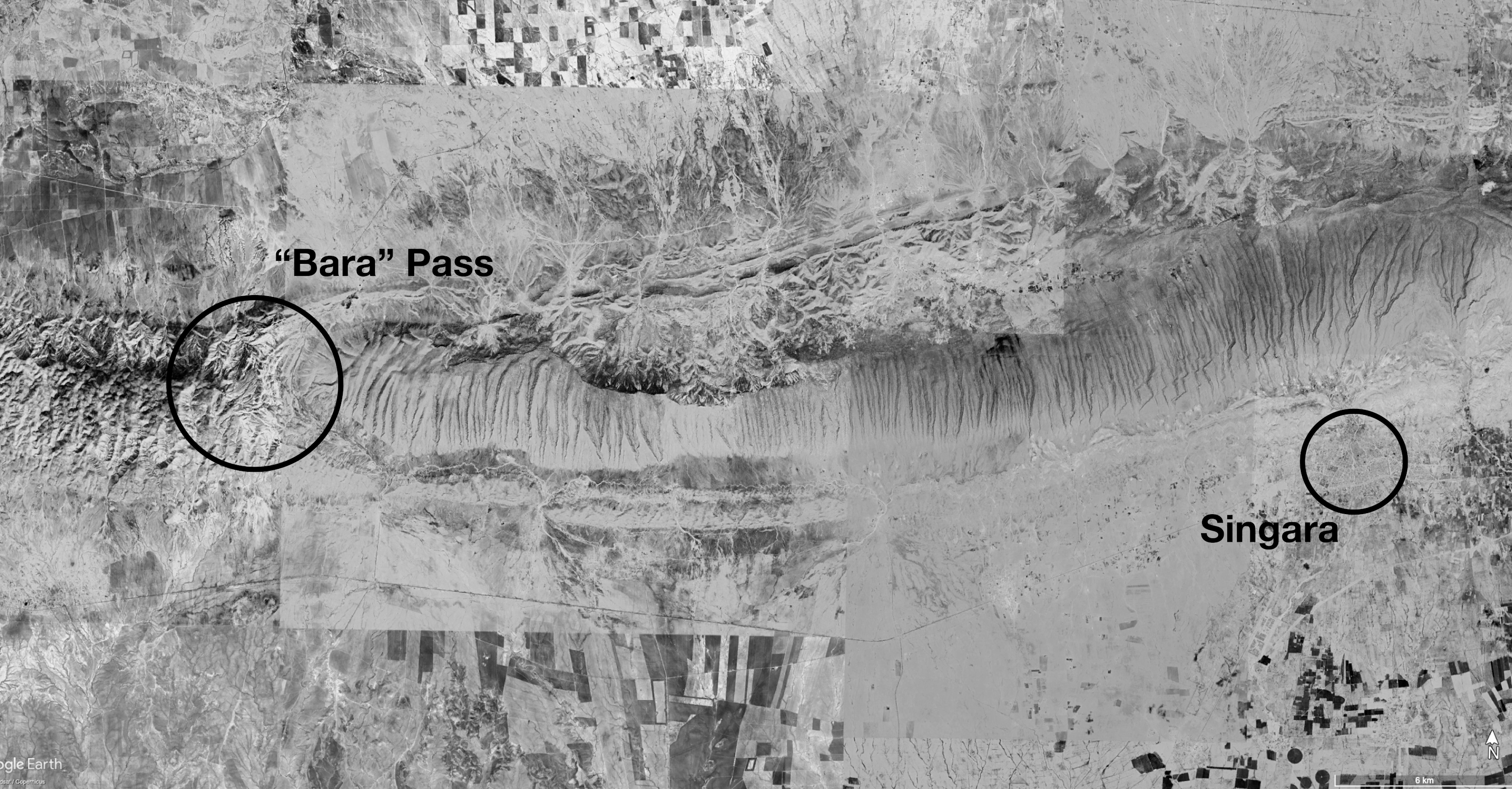
Figure 5: Composite satellite image with the location of the “Bara” pass and the modern-day city of Sinjar (Roman period Singara).
Credits/sources: ESRI/GeoEye, modified by the author.
The analysis of texts highlights a well-integrated economic scenario, which contributed to fostering regional mobility (this will be discussed later) as well as good levels of interaction between different social groups and economic agents. An interesting example of this comes from P.Euphrates 9, a sale contract from the town of Beth Phurin in which a certain Aurelios Oualeg [-] is mentioned as a centurion of the I Parthica in 252 CE (οίκουσα δέέν Νεσιβειν, συνπαρόωτος αύτη Αυρ(ηλίου) Ουαλεγ(εώνος) α Π(αρθικής) (έκατοντάρχου) πριμοπίλουάνδρος αύτής). Aurelios is listed as the husband of a woman who was the owner of a slave that the document reports as being sold in Nisibis. A similar transaction is also mentioned in P.Euphrates 8. In both texts, individuals from different villages of the Sphoracene establish economic activities at Nisibis (here defined as Septimia and Metropolis). The involvement of a Roman centurion in these economic transactions is an additional sign of the role Roman officials had in the social and administrative panorama of Mesopotamia. We can agree with T. Gnoli who rightly claims that there is no doubt that Aurelios was in charge of some administrative task in the provincial capital and that is wife was also somewhat involved in the urban economy.47 In addition, the date of the document—252—fits perfectly well with the apex of Roman control at Nisibis and the in trans-Euphratene in general, right before the mid-3rd century AD Sasanian invasion that caused, among others, the sack of Dura, and a long period of instability in the area. Data from Dura Europos and the Middle Euphrates region highlight how the Roman presence—through the agency of veterans and soldiers—profoundly modified the economic scenario of the region. People from Dura and the Euphrates valley participated in a well-integrated network of long-distance and regional trade, also indicating the relevance—for the Roman Empires—of controlling the Khabur River valley, a crucial region that connected Dura with Nisibis to the north.
Mobility and trade routes: Singara as a crossroad
P.Euphrates 8 and 9—as in many other cases from either the Middle Euphrates or Dura’s corpus—also denote the high degree of mobility of people, traders, and intermediaries that were implicated in commercial activities. People travelled for economic reasons from villages to regional centres and to capitals—both close ones like Nisibis, or more distant like Antioch.
Indeed, mobility was a key feature of the Classical Eastern Mediterranean, and the movements of people and goods were highly incentivised by local and wider economic opportunities. In addition, a common marker of the economic interaction along and beyond the borders of the Roman Empire is the central role the route network had in its success. Initially built to sustain the movement of large numbers of troops while advancing from place to place, the complex network of roman roads at the edge of the Empire ended up assuming a relevant position in multiple economic processes. In fact, in the Roman Near East, the correlation between economic hubs and routes—many of which pre-dated the Roman presence in the region—is evident and assumes a central role when discussing the economic potential of such a borderland zone. Most famous cases, in this regard, are the Via Traiana Nova and the Strata Diocletiana, respectively in Jordan and Syria.48 Although—and perhaps at an initial stage—differently conceived, these roads connected crucial areas of eastern provinces, assuring the double role of military and economic links. Both roads, however, exploited pre-Roman caravan routes, but became important backbones of the Roman expansion and territorial control in the Near East. Thus, the spatial distribution of these routes, and the related organisation of urban and military settlements along, is a central aspect for the understanding of mobility on the fringes of the Roman Empire.
In such a context, the Tabula Peutingeriana or Peutinger Map is an incredibly helpful tool, despite the issues that the document poses.49 The map is a parchment roll (6.94 m × 0.33 m) depicting the whole known world from Britannia to Sri Lanka, covering c. 70,000 miles of Roman roads. It is known by the name of the humanist Konrad Peutinger who first possessed the document in the 16th century AD. On the basis of palaeographic analysis, the current document is usually dated to the 13th century AD, and was possibly a copy redacted in Swabia, the southern region of Germany that borders Switzerland, and possibly inspired by a 4th century AD archetype, relying itself on a 1st century map.50 The chronology is largely based on the figurative prominence (walled and towered representations) of certain cities that assumed a certain relevance in the period between the 4th and the 5th century AD (i.e. Aquileia and Ravenna in northern Italy, or Ancyra and Nicomedia in Anatolia).51 Recently, R. Talbert has dedicated an enormously important work to the Peutinger Map (one that adds up to his previous literature to the topic), also enriching with redrawn digital maps and online repositories.52
This brief excursus serves to demonstrate the enormous relevance of the Peutinger Map for the reconstruction of a historical geography of the Later Roman Empire, and one that can contribute to the rediscovery of specific aspects of mobility and urban hierarchy in overlooked regions. And, as such, the importance of the document for the tentative reconstruction of the route network of Roman Mesopotamia is certainly beyond doubt. The region is represented on the segment X and although it appears extremely compressed—due to the format of the map itself—it shows all major centres of the area, with a more accurate depiction of the northern piedmont zone, perhaps reflecting Rome’s primary region of interest or the area that was better known—directly or indirectly—to the mapmaker. The major routes of the Peutinger Map in Northern Mesopotamia have already been discussed elsewhere,53 but it seems important here to assess the economic relevance of these routes in connection with the major cities of the region.
Rhesaina, Nisibis, and Singara are all marked with the two-house symbol, which indicates the importance of a stop point,54 and Singara seems to have played a role of fundamental importance in the commercial and military route system of Northern Mesopotamia. The city acted as a major nodal point for civilian and military movements, contributing to the creation of a relevant hub used alternately for trade and military operations. On the Peutinger Map, Singara is marked as a road station between Baba (or Bara) and Zagurae (mod. Ain Sinu), respectively 33 Roman miles westwards (c. 50 kms) and 21 Roman miles eastwards (c. 31.5 km). A second road reached Singara from the West, passing through the station of Sihinnus (30 Roman miles westwards, corresponding to c. 45 kms) and joining the road from Bara halfway between Bara itself and Singara, somewhere in the proximity of Tell Ḥayal.
Here, D. Oates reported the presence of a large square structure that he believed might have been erected during the Roman period.55 A third road arrived at Singara apparently from the north after having passed the station of Arcamo (?), 30 Roman miles north of the settlement. A Roman milestone, discovered 5 km SW of the modern centre of Sinjar, not far from the small village of Faghdani, and along modern asphalt that connects Sinjar with the Syrian-Iraqi border, testifies the existence and the use of a road during the period of Severus Alexander.56 The document bears the following inscription:57
Imp(erator) Caesar / M(arcus) Aurelius / Severus / Alexander / Pius [fel(ix)] Aug(ustus) / Pont(ifex) maxim(us) / Trib(unicia) / pot(estate) XI / Co(n)s(ul) III, [p(atriae), proc(onsul) / A Sing(ara) / M(ilia) p(assum) / III.
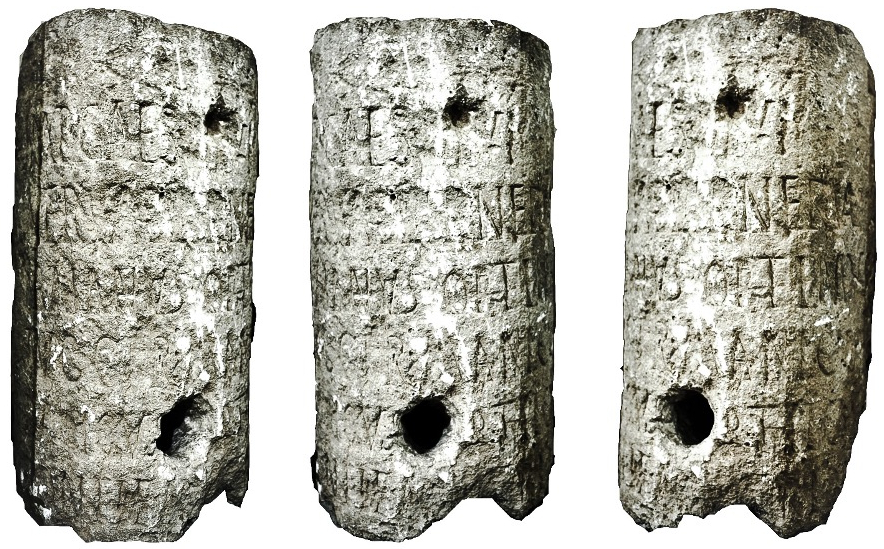
The mention of the 11th tribunicia potestas provides an accurate chronology for the inscription, which can be dated to 231/232 AD, but we can also assume that the road was repaired at that time. A second milestone, found at Karsi (or Kursi), a small village guarding a narrow gorge in the Jebel Sinjar, north of Singara, provides further interesting information (Fig. 6):58
Imp(erator) Caes(ar) [di]vi / Nervae f[i]l(ius) Nerva / Traianus Optimus / Aug(ustus) G[er]manicus / Dacicus [Pa]rthicus / pontif(ex) [max(imus) t]rib(unicia) [potes] / [tate ------
Figure 6: Three views of the Karsi milestone (now in the Erbil Civilization Museum, Iraqi Kurdistan).
Credits/sources: Photo and Digital Rendering: Author.
This inscription specifically mentions the title Parthicus, a reliable indication in regard to chronology, which should be looked for in the last years of the Trajanic campaigns in Mesopotamia when the emperor obtained the title following his achievements against the Parthians. The presence of such a document in middle of the Jebel Sinjar allows us to speculate about two different hypotheses. Assuming that the milestone was not significantly moved from its original position, one should suppose the existence both of a pass through the mountain west of Bara (the only accessible passage to cross the mountain), and of a second road linking Singara to the north—and hence to Nisibis—which cut through the plain, perhaps also following the Jaghjagh upstream. The road probably linked the area of Nisibis with Singara, and from here it continued towards the region of Hatra. Other possible routes went from the Tigris towards the Jaghjagh/Khabur confluence, and then along the river up to Circesium and the junction with the Euphrates.59 There is no evidence that this last road was purposely built for the Trajanic campaigns, or rather, and most likely, was a pre-existent track, but its exploitation—and perhaps maintenance—for the strategic movements of troops remains a very strong possibility.
In this way, the city controlled both the road below Jebel Sinjar, which connected the Upper Khabur valley with the Tigris to the east, and a second road from the north coming from the Jaghjagh basin and the Upper Khabur area. In the general framework of Roman military operations in North Mesopotamia as well as trade and commercial activities, these two axes where most probably the primary routes to follow in order to reach the eastern limits of the Empire from western Syria or Central Anatolia. Singara was also the departing point for a southern route towards Hatra and eastern one that touched the site of Ain Sinu/Zagurae60 before reaching the Tigris not far from the modern centre of Tell Afar, in northern Iraq. The former route seems to have passed through the villages of Tell Hatimyiah and Tell al-Hadhail, two large tells that were probably also settled during the Parthian and Roman period, when they may have been regular stopping points along this route. Indeed, several possible tracks (hollow ways) have been spotted between these sites, and generally all of them in the region are aligned along a north-west/south-east axis that roughly coincides with the direction from the Jebel Sinjar towards the region of Hatra.61
This complex route network must have benefitted many communities and favoured the cross-border connections with multiple economic agents. The permeability of the eastern frontier and the role major cities and market centres played in the regional context is thus accompanied by the involvement of local elites (small villages) and nomadic tribes (non-dwellers) in the economic processes of long-distance trade. Both groups functioned as a critical part of the urban-rural economic mechanism, which was evidently encouraged by such a high degree of mobility.
Conclusions
Roman soldiers and their interaction with local élites and communities played a significant role in the region’s economic life. On the basis of the data discussed so far, the involvement of Roman officials and the extent of Roman-period infrastructures must have greatly fostered the economy.
Multiple activities and the need for economic interactions between different social agents (and from different backgrounds) were based on the mutual benefit for the parties involved, and this process is visible in organised interactions at a larger geographical scale. The role of cities as hubs and market centres, strictly connected to villages and the regional context, speaks for a structured economic scenario, which was, at least until the mid-3rd century AD, only partly affected by the region’s liminality.
Textual data from Dura and the papyri of the Euphrates might thus be combined with evidence of the existence of caravan routes in the eastern part of Mesopotamia. The economic mobility of the various social agents in the Middle Euphrates and the Khabur valley was indeed permitted and incentivised by a likely similar route network. Routes from Dura to Nisibis have been seldom explored archaeologically, with a preference for the famous caravan trade route from Palmyra to the Euphrates and hence towards southern Mesopotamia and the Persian Gulf,62 but they might have asserted a similar function. The economic transactions that are mentioned in the textual records discussed above suggest that the Middle Euphrates region in the early 3rd century AD saw the province of Mesopotamia as an area of opportunity, and that cultural connections and mutual interest were maintained along the Euphrates-Khabur axis all the way up to Nisibis.
This scenario points to the recognition of the Dura and the Khabur-Euphrates confluence area and Northern Mesopotamia proper as zones of long-distance economic interventions, being connected respectively with Palmyra and the lower Euphrates, and western Syria and the Parthian Empire. Such an interconnected area contrasts with the traditional approach to exchange and interaction at the edges of the Roman Empire, but it fits perfectly within the pre-Roman context of the region, where different communities—each of them controlling specific economic structures—mutually benefitted from each other, with little or no geographic or political impediments. It is also evident that military activities and the military presence did not block local communities from interacting with both the armies and establishing economic relations with them. In this scenario, major cities acted as nodes of these interactions. When Nisibis was conquered again by Diocletian in 298 AD it soon became a centre for free trade in the contested space of Mesopotamia, and for period of c. 30 years the city grew wealthy and profited from this unique position. One might assume the same dynamic for Singara and Rhesaina. On the other hand, however, the varying fortunes of the military confrontation also impacted the socio-economic life of these urban centres. After the cession of Roman Mesopotamia to the Sasanians, in 364 AD, as reported by Ammianus Marcellinus (History, XXV, 7, 9-10), the inhabitants of Nisibis and Singara had to leave the cities and were moved towards Edessa.
These two examples perfectly delineate the ever-changing and dynamic nature of the Roman eastern borderland. Through the centuries, the Mesopotamian territory was at the same time a space of economic relations and military confrontations, a buffer zone in between the empires, and a transit zone for nomadic tribes and local communities. Texts from Dura allows us to assume that even in small villages along the Khabur and the Euphrates economic activities took place between their residents and the Roman military personnel, but to what extent were these villages Roman? There is no convincing archaeological evidence that supports the Roman impact on these minor centres and, in fact, outside the walls of major cities and strongholds, distinctly Roman material culture remains largely invisible. Eventually, the end of the Roman control and economic interaction in the steppe lands of Mesopotamia, following the death of Julian in 363 AD, had a probably significant impact on urban centres, and perhaps for certain segments of the local population—outside cities—while it was a relatively small impact on rural areas. In this regard, the best means of understanding the scale and extent of Roman military collapse in Mesopotamia is to be found in the archaeology of the urban centres.